Orava (region)


Orava is the traditional name of a region situated in northern Slovakia (as Orava) and partially also in southern Poland (as Orawa). It encompasses the territory of the former (comitatus) Árva County or Arwa (German).
Etymology
The name arises from the Orava river (a major river flowing through the region).
History
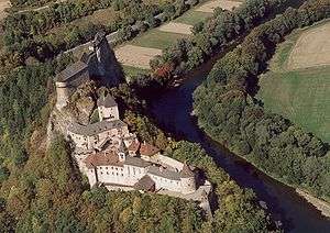
The whole territory belonged to the Kingdom of Hungary from 895 to 1920. The county arose before the 15th century. The county's territory was situated along the Orava River between Zázrivá and the Tatra Mountains. Its area amounted to 2,019 km² around 1910. The original seat of the county was Orava Castle.
Geography
Orava is now recognized as one of Slovakia's 21 tourist regions, however, it is not an administrative region unlike its predecessor. In Slovakia, Orava is divided between Dolný Kubín, Tvrdošín, and Námestovo districts in the Žilina Region. It has an area of 1,661 km²,[1] with the population on the Slovak side around 126,000.[2] The village of Oravská Polhora is the northernmost settlement of Slovakia. The most important town on the Slovak side (and also the seat of the former county) is Dolný Kubín. The Polish part of Orava belongs to the Lesser Poland Voivodeship, to the Nowy Targ County, with the main village of the Polish side being Jabłonka.
References
External links
Coordinates: 49°15′42″N 19°21′29″E / 49.261569°N 19.358056°E