Orange Park, Florida
| Orange Park, Florida | |
|---|---|
| Town | |
|
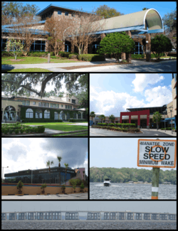
Top, left to right: Town Hall, Club Continental, Orange Park Mall, Best Bet, Doctors Lake, the Buckman Bridge viewed from Orange Park | |
 Location in Clay County and the state of Florida | |
| Coordinates: 30°10′7″N 81°42′31″W / 30.16861°N 81.70861°WCoordinates: 30°10′7″N 81°42′31″W / 30.16861°N 81.70861°W | |
| Country |
|
| State |
|
| County | Clay |
| Orange Park | 1877 |
| Government | |
| • Mayor | Eugene Nix |
| • Town Manager | Jim Hanson |
| Area | |
| • Total | 5.3 sq mi (13.7 km2) |
| • Land | 3.6 sq mi (9.4 km2) |
| • Water | 1.7 sq mi (4.4 km2) |
| Elevation | 13 ft (4 m) |
| Population (2013) | |
| • Total | 8,570 |
| • Density | 2,321/sq mi (896.1/km2) |
| Time zone | Eastern (EST) (UTC-5) |
| • Summer (DST) | EDT (UTC-4) |
| ZIP codes | 32000-32099 |
| Area code(s) | 904 |
| FIPS code | 12-52125[1] |
| GNIS feature ID | 0288219[2] |
| Website |
www |
Orange Park is a town in Clay County, Florida, United States, and a suburb of Jacksonville. The population was 8,412 at the 2010 census.[3] The name "Orange Park" is additionally applied to a wider area of northern Clay County outside the town limits, covering such communities as Fleming Island, Lakeside, and Bellair-Meadowbrook Terrace.
The town's name reflects the hope of its founders for a fruit-growing industry, but their crops were destroyed in the Great Freeze of 1894–95. Despite recovery elsewhere, the crops never came back to Orange Park.
History

Orange Park in the late 18th century was known simply as Laurel Grove. The name Laurel Grove comes from Sarah and William Pengree who received a land grant from the Spanish governor. Laurel Grove was sold to Zephaniah Kingsley of the Kingsley Plantation upon William's death. Zephaniah developed Laurel Grove into a model farming plantation for over 10 years. In 1813 General Matthews invaded East Florida triggering the Patriots Rebellion. After Mathews left East Florida Zephaniah's wife Anna Madgigine Jai Kingsley burned down Laurel Grove to keep it out of Patriots hands.[4]
The Town of Orange Park was founded in 1877 by the Florida Winter Home and Improvement Company. Following the Civil War, the company purchased several thousand acres of the McIntosh plantation at Laurel Grove, for the purpose of creating a southern retreat and small farming community. The property was subdivided into building lots and small farm tracts where the present street system was laid out including Kingsley Avenue and Plainfield Avenue. The town was incorporated in 1879 by a special act of the Florida Legislature. In January 1880 Ulysses S. Grant and Philip Sheridan visited Orange Park.[5] A large hotel was constructed at Kingsley Avenue along with a 1200-foot pier.[4] In 1895 the fruit growing industry was destroyed in the Great Freeze of 1895.[6]
Geography
Orange Park is located in the northeast corner of Clay County on the St. Johns River at 30°10′7″N 81°42′31″W / 30.16861°N 81.70861°W (30.168569, -81.708479).[7] Orange Park is a suburb of Jacksonville and is located adjacent to the southern limits of the city. The area known as Greater Orange Park encompasses the unincorporated communities of Fleming Island, Ridgewood, Doctors Inlet, Orange Park South, Lakeside, and Bellair-Meadowbrook Terrace.
According to the United States Census Bureau, the town has a total area of 5.3 square miles (13.7 km2), of which 3.6 square miles (9.4 km2) is land and 1.7 square miles (4.4 km2) of it, or 31.71%, is water.[3]
Orange Park Elementary School, built in 1927, continues to operate a few blocks from the river. It is adjacent to Moose Haven which sits directly on the River Road Historic District, a stretch of road dotted with century old trees parallel to the Saint Johns River and where many locals come to jog or promenade in the afternoon. A few meters away is Club Continental, previously called Mira Rio. Mira Rio or River Watch in Spanish was the winter palazzo of Caleb Johnson, son of the founder of the Palmolive Soap Company, now the billion-dollar Colgate-Palmolive company.
Many households are either affiliated with the military, with the presence of NAS Jacksonville less than 6 miles (10 km) away, or are in the medical field.
Demographics
| Historical population | |||
|---|---|---|---|
| Census | Pop. | %± | |
| 1880 | 134 | — | |
| 1890 | 228 | 70.1% | |
| 1900 | 245 | 7.5% | |
| 1910 | 372 | 51.8% | |
| 1920 | 333 | −10.5% | |
| 1930 | 661 | 98.5% | |
| 1940 | 668 | 1.1% | |
| 1950 | 1,502 | 124.9% | |
| 1960 | 2,624 | 74.7% | |
| 1970 | 5,019 | 91.3% | |
| 1980 | 8,766 | 74.7% | |
| 1990 | 9,488 | 8.2% | |
| 2000 | 9,081 | −4.3% | |
| 2010 | 8,412 | −7.4% | |
| Est. 2015 | 8,702 | [8] | 3.4% |
As of the census[1] of 2010, there were 8,412 people, a 7.4% decline from 2000; there were 3,464 households, and 2,215 families residing in the town. The population density was 2,331.1 people per square mile (899.0/km²). There were 3,648 housing units at an average density of 936.4 per square mile (361.2/km²). The racial makeup of the town was 75.9% White, 14.8% African American, 0.3% Native American, 3.2% Asian, 0.1% Pacific Islander, 2.3% from other races, and 3.4% from two or more races. Hispanic or Latino of any race were 8.8% of the population. In addition, mirroring Jacksonville, the town has one of the highest percentage of Filipino Americans in the state of Florida.
There were 3,464 households out of which 23.2% had children under the age of 18 living with them, 45.0% were married couples living together, 14.0% had a female householder with no husband present, and 36.1% were non-families. 30.6% of all households were made up of individuals and 34.5% had someone living alone who was 65 years of age or older. The average household size was 2.33 and the average family size was 2.89.
In the town the population was spread out with 21.0% under the age of 18, 7.9% from 18 to 24, 24.8% from 25 to 44, 25.3% from 45 to 64, and 21.0% who were 65 years of age or older. The median age was 43 years. For every 100 females there were 90.3 males. For every 100 females age 18 and over, there were 87.7 males.
The median income for a household in the town was $47,631, and the median income for a family was $58,093. Males had a median income of $36,590 versus $26,846 for females. The per capita income for the town was $24,087. About 4.6% of families and 7.5% of the population were below the poverty line, including 10.8% of those under age 18, 17.1% of those age 65 or over.
Education
Orange Park is located inside the Clay County School District and is home to three public elementary schools and two public junior high schools, and lastly 3 high schools. An additional ten public elementary schools, two public junior high schools, and three public high schools are located outside the town limits.[10] Orange Park is also home to several private schools and to Fortis College, a for-profit two-year college. The St. Johns River Community College has an Orange Park campus for a two-year or four-year college degree.
Orange Park High School is the closest public high school, located 1 mile (2 km) west of the town limits. Oakleaf High School is the second closest public high school, located about 2 miles south-west of town limits. Ridgeview High School is the third closest, located about 3 miles south of town limits.
Notable residents
- Slim Whitman, singer
- Kat Cole, CEO of Cinnabon
- Hank Garland, guitarist
- Billy Powell, keyboardist of Lynyrd Skynyrd
- Adrian White, NFL defensive back and current assistant coach for the Buffalo Bills
- Dez White, retired NFL wide receiver
- Chevy Kehoe White Supremacist and Prisoner at ADX Florence
References
- 1 2 "American FactFinder". United States Census Bureau. Retrieved 2008-01-31.
- ↑ "US Board on Geographic Names". United States Geological Survey. 2007-10-25. Retrieved 2008-01-31.
- 1 2 "Geographic Identifiers: 2010 Demographic Profile Data (G001): Orange Park town, Florida". U.S. Census Bureau, American Factfinder. Retrieved June 26, 2014.
- 1 2 "Brief History of the Town of Orange Park". Retrieved June 28, 2014.
- ↑ "Orange Park". drbronsontours.com. drbronsontours.com. Retrieved 11 March 2016.
- ↑ "Orange Park". drbronstours.com. Retrieved June 28, 2014.
- ↑ "US Gazetteer files: 2010, 2000, and 1990". United States Census Bureau. 2011-02-12. Retrieved 2011-04-23.
- ↑ "Annual Estimates of the Resident Population for Incorporated Places: April 1, 2010 to July 1, 2015". Retrieved July 2, 2016.
- ↑ "Census of Population and Housing". Census.gov. Archived from the original on May 11, 2015. Retrieved June 4, 2015.
- ↑ http://www.clay.k12.fl.us/Schools.htm
External links
Municipalities and communities of Clay County, Florida, United States | ||
|---|---|---|
| Cities | 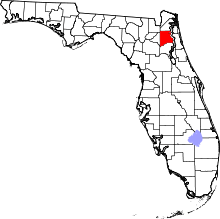 | |
| Towns | ||
| CDPs | ||
| Unincorporated communities | ||
| Footnotes | ‡This populated place also has portions in an adjacent county or counties | |
| Central city |  | |
|---|---|---|
| Municipalities over 10,000 population (in 2000) | ||
| Municipalities 1,000-10,000 population (in 2000) |
| |
| Counties | ||