Opglabbeek
| Opglabbeek Glabbek (Limburgs) | |||
|---|---|---|---|
| Municipality | |||
 | |||
| |||
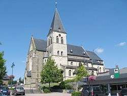
 Opglabbeek Location in Belgium | |||
|
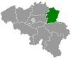
Location of Opglabbeek in Limburg  | |||
| Coordinates: 51°03′N 05°35′E / 51.050°N 5.583°ECoordinates: 51°03′N 05°35′E / 51.050°N 5.583°E | |||
| Country | Belgium | ||
| Community | Flemish Community | ||
| Region | Flemish Region | ||
| Province | Limburg | ||
| Arrondissement | Hasselt | ||
| Government | |||
| • Mayor | Benny Spreeuwers (CD&V) | ||
| • Governing party/ies | CD&V | ||
| Area | |||
| • Total | 24.98 km2 (9.64 sq mi) | ||
| Population (1 January 2016)[1] | |||
| • Total | 10,297 | ||
| • Density | 410/km2 (1,100/sq mi) | ||
| Postal codes | 3660 | ||
| Area codes | 089 | ||
| Website | www.opglabbeek.be | ||


Opglabbeek (Limburgs: Glabbek) is a municipality located in the Belgian province of Limburg. On January 1, 2012, Opglabbeek had a total population of 10,162. The total area is 24.98 km² which gives a population density of 385 inhabitants per km².
The municipality consists of the following communities: Opglabbeek proper, Nieuwe Kempen, and Louwel.
References
- ↑ Population per municipality as of 1 January 2016 (XLS; 397 KB)
External links
-
 Media related to Opglabbeek at Wikimedia Commons
 - Official website (Dutch)
 |
Meeuwen-Gruitrode | | ||
| Meeuwen-Gruitrode Houthalen-Helchteren |
|
Maaseik | ||
| ||||
| | ||||
| Genk | As |
This article is issued from Wikipedia - version of the 12/1/2016. The text is available under the Creative Commons Attribution/Share Alike but additional terms may apply for the media files.