Hurricane Andrew
| Category 5 major hurricane (SSHWS/NWS) | |
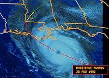
 Hurricane Andrew at peak intensity | |
| Formed | August 16, 1992 |
|---|---|
| Dissipated | August 28, 1992 |
| Highest winds |
1-minute sustained: 175 mph (280 km/h) |
| Lowest pressure | 922 mbar (hPa); 27.23 inHg |
| Fatalities | 65 |
| Damage |
$26.5 billion (2016 USD) (Fifth costliest tropical cyclone in U.S. history) |
| Areas affected | The Bahamas; South Florida, Louisiana, and other areas of the Southern United States |
| Part of the 1992 Atlantic hurricane season | |
|
Effects Other wikis | |
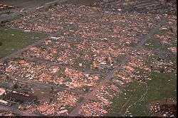
Hurricane Andrew was, at the time of its occurrence in August 1992, the most destructive hurricane in United States history. It caused major damage in the Bahamas and Louisiana, but the greatest impact was in South Florida, where it made landfall at Category 5 hurricane intensity on the Saffir–Simpson hurricane scale, with wind speeds up to 165 mph (270 km/h). Passing directly through the town of Homestead, Florida, a city south of Miami, Andrew obliterated entire blocks of homes, in many cases leaving only the concrete foundations. Over 25,000 houses were destroyed in Miami-Dade County alone, and nearly 100,000 more were severely damaged. 65 people were killed and the damage total across the affected regions exceeded $26 billion (1992 USD).
Andrew originated from a tropical wave over the central Atlantic, becoming the fourth tropical cyclone and the first hurricane of the 1992 Atlantic hurricane season. Initially, strong wind shear prevented much intensification, but after turning westward, Andrew entered a stage of rapid intensification; it peaked as a powerful Category 5 hurricane near the Bahamas on August 23. Though it briefly weakened to Category 4 strength while traversing the island nation, Andrew regained its Category 5 status before making two separate landfalls in South Florida—the first on Elliott Key and the second in Homestead. In Miami-Dade County alone, damage was originally estimated at $25 billion (1992 USD). Several hours later, the hurricane emerged over the Gulf of Mexico at Category 4 strength, with the Gulf Coast of the United States in its projected path. After weakening slightly, Andrew moved ashore near Morgan City, Louisiana, as low-end Category 3 storm. The effects of land caused the small hurricane to rapidly lose its intensity, and it diminished to a depression by August 27 while crossing Mississippi. The next day, Andrew merged with a frontal system over the southern Appalachian Mountains.
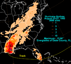
In the Bahamas, Andrew brought storm surge, hurricane-force winds, and tornadoes, causing widespread structural damage, especially on Cat Cays. About 800 houses were destroyed in the archipelago, and there was substantial damage to the transport, water, sanitation, agriculture, and fishing sectors. Overall, Andrew left four dead and $250 million (1992 USD)[nb 1] in damage throughout the Bahamas. In parts of southern Florida, Andrew produced severe winds; a wind gust of 177 mph (282 km/h) was observed at a house in Perrine. These winds wreaked catastrophic damage in Florida—Miami-Dade County cities of Florida City, Homestead, and Cutler Ridge receiving the brunt of the storm. A total of 63,000 homes were destroyed and more than 101,000 others were damaged, leaving roughly 175,000 people homeless. As many as 1.4 million people lost power at the height of the storm. In the Everglades, 70,000 acres (280 km2) of trees were downed. Rainfall in Florida was substantial, peaking at 13.98 in (355 mm) in western Miami-Dade County. Altogether, Andrew killed 44 and left a record $25 billion in damage in the state.
Before moving ashore Andrew caused extensive damage to oil platforms in the Gulf of Mexico, leading to $500 million in losses for oil companies. It produced hurricane-force winds along its path through Louisiana, leaving about 152,000 without electricity. Over 80% of trees in the Atchafalaya River Basin were downed, and the agriculture there was devastated. Throughout the basin and Bayou Lafourche, 187 million freshwater fish were killed in the hurricane. An F3 tornado in St. John the Baptist Parish wrecked 163 structures. With 23,000 houses damaged, 985 others destroyed, and 1,951 mobile homes demolished, property losses in Louisiana exceeded $1.5 billion. The hurricane caused the deaths of 17 people in the state, six of whom drowned offshore.
Andrew spawned at least 28 tornadoes along the Gulf Coast, especially in Alabama, Georgia, and Mississippi. Throughout its path, Andrew left 65 dead and $26 billion in damage (1992 USD, $43.9 billion 2016 USD); it is currently the fifth costliest hurricane in Atlantic hurricane history, behind only hurricanes Katrina and Wilma in 2005, Ike in 2008, and Sandy in 2012.
Meteorological history
| Strongest U.S. landfalling hurricanes*† | |||||
|---|---|---|---|---|---|
| Rank | Hurricane | Season | Wind speed | ||
| Mph | Km/h | ||||
| 1 | “Labor Day” | 1935 | 185 | 295 | |
| 2 | Camille | 1969 | 175 | 280 | |
| 3 | Andrew | 1992 | 165 | 265 | |
| 4 | |||||
| “Last Island” | 1856 | 150 | 240 | ||
| “Indianola” | 1886 | 150 | 240 | ||
| “Florida Keys” | 1919 | 150 | 240 | ||
| “Freeport” | 1932 | 150 | 240 | ||
| Charley | 2004 | 150 | 240 | ||
| 9 | "Great Miami" | 1926 | 145 | 230 | |
| "Okeechobee" | 1928 | 145 | 230 | ||
| Source: HURDAT,[1] Hurricane Research Division[2] | |||||
| *List refers to hurricanes that struck the lower 48 states, excluding U.S. territories elsewhere. †Strength refers to maximum sustained wind speed | |||||
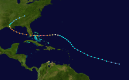
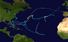
A tropical wave moved off the coast of Africa on August 14. Under the influence of a ridge of high pressure to its north, the wave tracked quickly westward. An area of convection developed along the wave axis to the south of the Cape Verde islands, and on August 15, meteorologists began classifying the system with the Dvorak technique. The thunderstorm activity became more concentrated, and narrow spiral rainbands developed around a developing center of circulation. Based on a Dvorak T-number of 2.0, it is estimated that Tropical Depression Three developed late on August 16, while about 1,630 miles (2,620 km) east-southeast of Barbados.[3] Embedded within the deep easterlies, the depression tracked west-northwestward at 20 mph (32 km/h).[4] Initially, moderate wind shear prevented strengthening, until a decrease in shear allowed the depression to intensify into Tropical Storm Andrew at 1200 UTC on August 17.[3]
By early August 18, the storm maintained concentrated convection near the center with spiral bands to its west as the winds increased to 50 mph (80 km/h).[5] Shortly thereafter the thunderstorms decreased markedly during the diurnal minimum[6] and as the storm turned to the northwest, increased southwesterly wind shear from an upper-level low prevented Andrew from maintaining deep convection.[3] On August 19, a Hurricane Hunters flight into the storm failed to locate a well-defined center[7] and on the following day, a flight found that the cyclone had degenerated to the extent that only a diffuse low-level circulation center remained; observations indicated the pressure rose to an unusually high 1,015 mbar (30.0 inHg). The flight indicated Andrew maintained a vigorous circulation aloft, with winds of 80 mph (130 km/h) recorded at flight level. Subsequently, the upper-level low weakened and split into a trough, which decreased the wind shear over the storm. Simultaneously, a strong high pressure cell developed over the southeastern United States, which built eastward and caused Andrew to turn to the west.[3] Convection became more organized as upper-level outflow became better established.[8] An eye formed, and Andrew attained hurricane status early on August 22, while located about 650 miles (1,050 km) east-southeast of Nassau, Bahamas.[3] In the forecast issued six hours after becoming a hurricane, Andrew was predicted to make landfall near Jupiter, Florida with winds of 105 mph (169 km/h) on the 25th.[9] This both underestimated the strength and the speed of the storm which would eventually make landfall in South Florida.
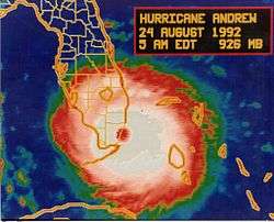
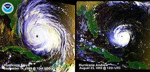
The hurricane accelerated as it tracked due westward into an area of very favorable conditions, and began to rapidly intensify late on August 22; in a 24‑hour period the atmospheric pressure dropped by 47 mbar (47 hPa; 1.4 inHg) to a minimum of 922 mbar (922 hPa; 27.2 inHg).[3] On August 23, the storm attained Category 5 status on the Saffir–Simpson hurricane scale, and at 1800 UTC, Andrew reached peak winds of 175 mph (280 km/h) while located a short distance off Eleuthera island in the Bahamas.[nb 2][10] Operationally, the National Hurricane Center assessed its peak intensity as 150 mph (240 km/h),[11] which was upgraded to 155 mph (249 km/h) in a post-analysis after the season ended; the hurricane was later re-classified as a Category 5 hurricane.[10] Even with winds of 175 mph (280 km/h), Andrew was a small tropical cyclone, with winds of 35 mph (56 km/h) extending out only about 90 miles (140 km) from its center.[12] After reaching that intensity, the hurricane underwent an eyewall replacement cycle.[13] At 2100 UTC on August 23, Andrew made landfall on Eleuthera with winds of 160 mph (260 km/h).[10] The cyclone weakened further while crossing the Bahama Banks, and at 0100 UTC on August 24, Andrew hit the southern Berry Islands of the Bahamas with winds of 150 mph (240 km/h).[10] As it crossed over the warm waters of the Gulf Stream, the hurricane rapidly re-intensified as the eye decreased in size and its eyewall convection deepened.[3] At 0840 UTC on August 24, Andrew struck Elliott Key with winds of 165 mph (266 km/h) and a pressure of 926 mbar (27.3 inHg). About 25 minutes after its first Florida landfall, Andrew hit just northeast of Homestead with a slightly lower pressure of 922 mbar (922 hPa; 27.2 inHg).[10]
| Rank | Hurricane | Season | Landfall pressure |
|---|---|---|---|
| 1 | "Labor Day" | 1935 | 892 mbar (hPa) |
| 2 | Camille | 1969 | 900 mbar (hPa) |
| 3 | Katrina | 2005 | 920 mbar (hPa) |
| 4 | Andrew | 1992 | 922 mbar (hPa) |
| 5 | "Indianola" | 1886 | 925 mbar (hPa) |
| 6 | "Florida Keys" | 1919 | 927 mbar (hPa) |
| 7 | "Okeechobee" | 1928 | 929 mbar (hPa) |
| 8 | "Great Miami" | 1926 | 930 mbar (hPa) |
| Donna | 1960 | 930 mbar (hPa) | |
| 10 | Carla | 1961 | 931 mbar (hPa) |
| Source: HURDAT,[1] Hurricane Research Division[2] | |||
As the eye moved onshore in Florida, the convection in the eyewall strengthened due to increased convergence, and Hurricane Hunters reported a warmer eyewall temperature than two hours prior. However, Andrew weakened as it continued further inland, and after crossing southern Florida in four hours, the storm emerged into the Gulf of Mexico with winds of 135 mph (217 km/h).[3] In the Gulf of Mexico, the eye remained well-defined as the hurricane turned to the west-northwest, a change due to the weakening of the ridge to its north.[14] Andrew steadily re-intensified over the Gulf of Mexico, reaching winds of 145 mph (233 km/h) late on August 25.[10] As the high pressure system to its north weakened, a strong mid-latitude trough approached the area from the northwest. This caused the hurricane to decelerate to the northwest, and winds decreased as Andrew approached the Gulf Coast of the United States.[3] At 0830 UTC on August 26, the cyclone made its final landfall in a sparsely populated area of Louisiana about 20 miles (32 km) west-southwest of Morgan City with winds of 115 mph (185 km/h).[10] Hurricane Andrew weakened rapidly as it turned to the north and northeast, falling to tropical storm intensity within ten hours. After entering Mississippi, the cyclone deteriorated to tropical depression status early on August 27. Accelerating northeastward, the depression began merging with the approaching frontal system, and by midday on August 28, Andrew ceased to meet the qualifications of a tropical cyclone while located over the southern Appalachian Mountains.[3] The remnants continued moving towards northeast and lost its identity on August 28, while merging with the remnants of Hurricane Lester within the frontal zone over the Mid-Atlantic states.[15]
Preparations
Bahamas
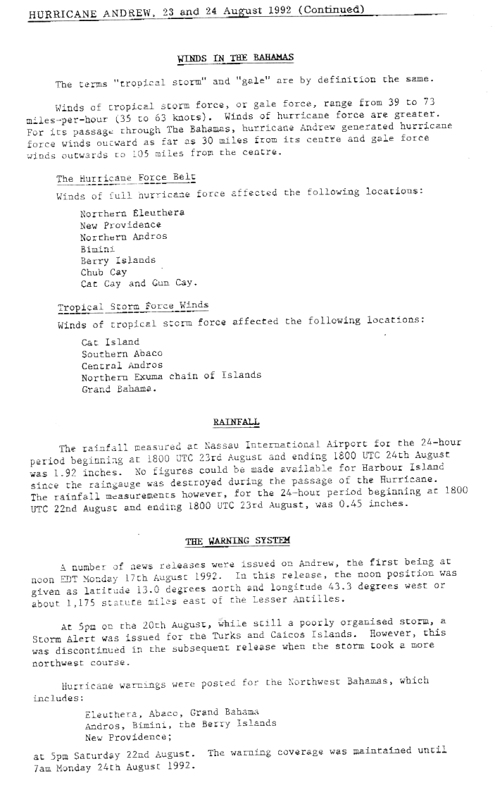
Before the hurricane passed through the Bahamas, forecasters predicted a storm surge of up to 18 ft (5.5 m), as well as up to 8 in (200 mm) of rain.[16] On August 22, hurricane watches were issued from Andros and Eleuthera islands northward through Grand Bahama and Great Abaco. They were upgraded to hurricane warnings later that day, and on August 23, additional warnings were issued for the central Bahamas, including Cat Island, Exuma, San Salvador Island, and Long Island. All watches and warnings were discontinued on August 24.[3] Advance warning was credited for the low death toll in the country.[17]
Florida
Initially, forecasters predicted tides up to 14 feet (4.3 m) above normal along the east coast of Florida, near the potential location of landfall.[18] The National Hurricane Center later noted that storm surge up to 10 feet (3.0 m) would occur along the east coast of Florida, as high as 13 feet (4.0 m) in Biscayne Bay, and to a height of 11 feet (3.4 m) of the west coast of Florida. Rainfall was predicted to be between 5 and 8 inches (130 and 200 mm) along the path of the storm. In addition, the National Hurricane Center noted the likelihood of isolated tornadoes in Central and Southern Florida during the passage of Andrew on August 23 and August 24.[19]
Late on August 22, a hurricane watch was issued for the east coast of Florida from Titusville to the Florida Keys, which included Dry Tortugas. On the following day, a hurricane warning was posted from Vero Beach southward to the Florida Keys, including Dry Tortugas. To the north, the east coast of Florida from Vero Beach to Titusville was placed under a tropical storm warning on August 23. Simultaneously, a hurricane watch was issued for the west coast of Florida from Bayport southward to near Flamingo. Later that day, the portion to the south of Venice was upgraded to a hurricane warning and was expanded to include Lake Okeechobee. To the north of Venice, the hurricane watch was downgraded to a tropical storm warning. By 1800 UTC on August 24, all watches and warnings issued in anticipation of the storm were discontinued.[3]
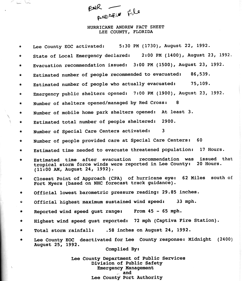
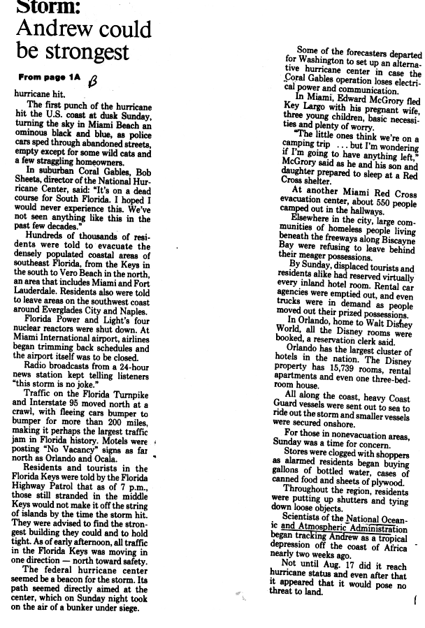
Evacuations were ordered in nine counties: Broward, Charlotte, Collier, Lee, Martin, Miami-Dade, Monroe, Palm Beach, and Sarasota. In addition, officials in Lee County recommended an evacuation for the county on August 23, about 20 hours before tropical storm force winds were reported there.[20] Overall, almost 1.2 million people evacuated, which contributed to low number of fatalities, despite the intensity of the storm.[3] United States Coast Guard vessels on or near the Florida coastline were either secured onshore or sent to ride out the storm at sea.[21] As Andrew was approaching, an estimated 20,000-30,000 tourists were in the Florida Keys (Monroe County).[22] Ultimately, the sheer number of evacuees led to likely the largest traffic jam in the history of Florida, mostly along Interstate 95.[21]
Gulf Coast of the United States
While the hurricane was approaching the Gulf Coast of the United States, the National Hurricane Center issued a hurricane watch from Mobile, Alabama to Vermilion Bay, Louisiana, about 43 hours before landfall. Eight hours later, the agency upgraded the watch to a warning from Pascagoula, Mississippi to Vermilion Bay, which was later extended to Bolivar Peninsula, Texas. Due to the hurricane's threat, about 1.25 million people evacuated the Louisiana coast, and another 250,000 people evacuated from Orange and Jefferson counties in Texas.[3] Despite the severity of the storm, New Orleans Mayor Sidney Barthelemy only ordered a voluntary evacuation for the city, while portions of the New Orleans area went under mandatory evacuation orders, mainly in the lowest lying areas.
Impact
| Rank | Hurricane | Season | Damage | ||
|---|---|---|---|---|---|
| 1 | Katrina | 2005 | $108 billion | ||
| 2 | Sandy | 2012 | $71.4 billion | ||
| 3 | Ike | 2008 | $29.5 billion | ||
| 4 | Andrew | 1992 | $26.5 billion | ||
| 5 | Wilma | 2005 | $21 billion | ||
| 6 | Ivan | 2004 | $18.8 billion | ||
| 7 | Irene | 2011 | $15.6 billion | ||
| 8 | Charley | 2004 | $15.1 billion | ||
| 9 | Rita | 2005 | $12 billion | ||
| 10 | Matthew | 2016 | $10.6 billion | ||
| Source: National Hurricane Center[23][24][25][nb 3] | |||||
Though Andrew was a small tropical cyclone for most of its lifespan, it caused extreme damage, especially in the Bahamas, Florida, and Louisiana. The vast majority of the damage was as a result of extremely high winds, although a few tornadoes spawned by Andrew caused considerable damage in Louisiana. Throughout the areas affected, almost 177,000 people were left homeless. Outside of the Bahamas, Florida, and Louisiana, effects were widespread, although damage was minimal. Overall, $26.5 billion in losses and 65 fatalities were attributed to Andrew.[3] Many other estimates, however, indicate Andrew caused next to $34 billion in damage overall.[26] As a result of damage in Florida and Louisiana, Andrew was listed as the costliest hurricane in U.S. history, but is now fourth following Hurricanes Katrina (2005), Sandy (2012), and Ike (2008).[27]
Bahamas
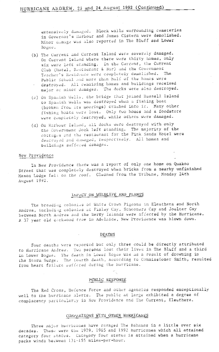
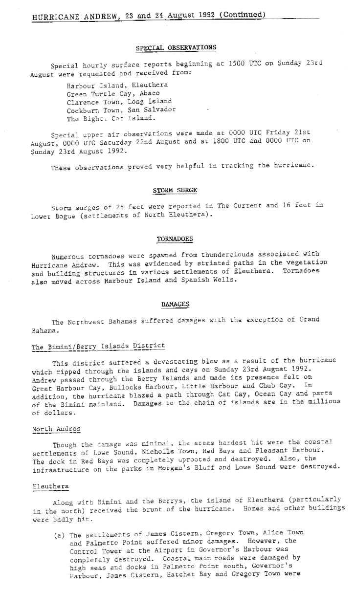
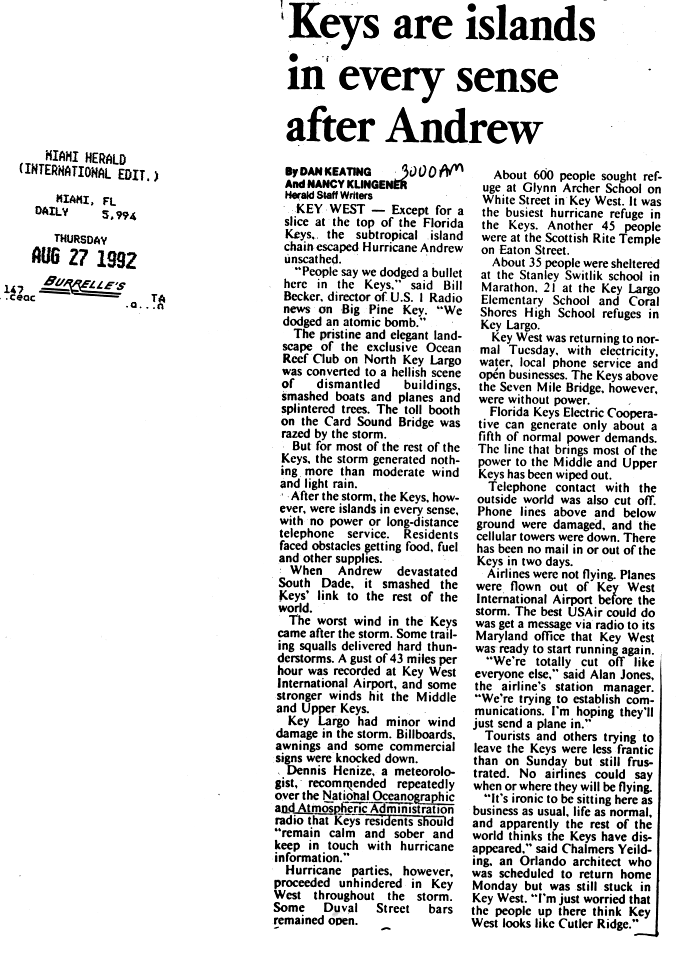
In the Bahamas, Andrew produced hurricane-force winds in North Eleuthera, New Providence, North Andros, Bimini, Berry Islands.[28] The storm first struck Eleuthera,[29] where it produced a high storm surge.[17] At a small village in the northwestern portion of the island, more than half of the houses were destroyed and the rest of the buildings sustained minor to major damage. One person drowned from the surge in Lower Bogue, Eleuthera, and two others died in nearby The Bluff. On Current Island, the hurricane destroyed 24 of the 30 houses.[30] Harbour Island, also located near Eleuthera, reported wind gusts of 138 mph (222 km/h) – the strongest gust speed observed in the Bahamas during Andrew's passage.[3] News reports indicated severe damage to 36 houses on Harbor Island.[31]
Andrew produced several tornadoes in the area.[32] At the capital city of Nassau, sustained winds reached 92 mph (148 km/h), while gusts up to 115 mph (185 km/h) were reported.[3] According to the Bahamas Red Cross, only minor damage occurred in Nassau.[31] However, on the private island of Cat Cay, many expensive homes sustained heavy damage.[33] Much of the northwestern Bahamas received damage,[32] with estimates reaching $250 million.[3] A total of 800 houses were destroyed, leaving 1,700 people homeless. Additionally, the storm cause severe damage to the sectors of transport, communications, water, sanitation, agriculture, and fishing.[31] Four deaths in the country were attributed to the hurricane, of which three were direct;[3] the indirect fatality was due to heart failure during the passage of the storm.[30]
Florida
Tides were generally between only 4 to 6 feet (1.2 to 1.8 m) above normal in the Biscayne Bay area, though near the Burger King International Headquarters, tides reached as high as 16.9 feet (5.2 m) above normal. Storm surge on the west coast was widespread, but mostly light, with a peak height of 6 feet (1.8 m), measured at both Everglades City and Goodland. The storm surge was reported as far north as Homosassa. Strong winds from the storm were confined to a relatively small area, stretching from Key Largo to about Miami Beach. A house in Perrine initially reported a wind gust of 212 mph (341 km/h); this measurement was reduced to 177 mph (285 km/h), after a wind-tunnel testing at Clemson University of the same type of anemometer revealed a 16.5% error. At some locations, the instruments measuring wind speeds failed before the highest winds occurred. At the National Hurricane Center, sustained winds of 115 mph (185 km/h) and gusts to 164 mph (264 km/h) were measured before the anemometer failed. The highest sustained wind speed in relation to the storm was 146 mph (235 km/h), recorded at the Turkey Point Nuclear Generating Station, before instruments failed there, too. In Key Largo, a 13-minute wind speed of 114 mph (183 km/h) was reported. Tropical storm force winds reached as far north as West Palm Beach. On the west coast of Florida, sustained winds did not exceed 39 mph (63 km/h) at Marco Island, though a wind gust of 100 mph (160 km/h) was reported in Collier County. Rainfall was generally light, possibly as a result of the storm's relatively fast movement.[3] Overall, precipitation from Andrew peaked at nearly 14 inches (360 mm) in western Miami-Dade County. Heavy rainfall in other areas was sporadic, with precipitation reported as far north as Central Florida.[15]
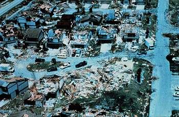
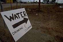
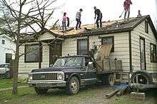
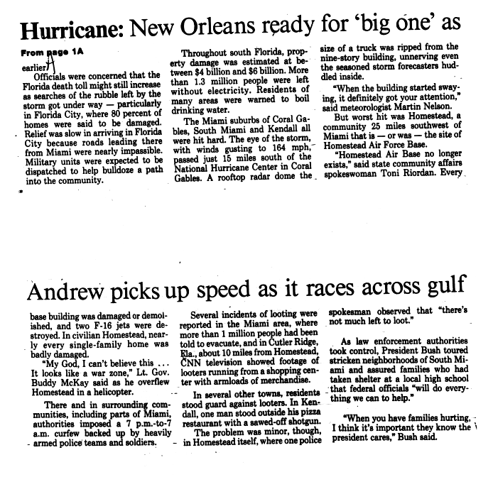
Storm surge from Andrew caused more than $500 million in losses to boats and a hotel, which had its lobby flooded with 2 to 3 feet (0.61 to 0.91 m) of water.[3][34] Almost all the damage in Florida was caused by strong winds.[35] Although effects from Andrew were catastrophic, the extent of damage was limited mainly from Kendall to Key Largo due to the small wind field of the storm.[3] At the height of the storm, more than 1.4 million people lost electricity and another 150,000 were without telephone service.[36] It is estimated that throughout Florida some 63,000 homes were destroyed, leaving at least 175,000 people homeless.[37] In addition to homes, the storm damaged or destroyed 82,000 businesses, 32,900 acres of farmland, 31 public schools, 59 health facilities/hospitals, 9,500 traffic signals, 3,300 miles (5,300 km) of power lines, and 3,000 watermains.[36] At the Homestead Air Force Base, re-opened two years later as Homestead Air Reserve Base, most of the 2,000 buildings on the base became "severely damaged or unusable".[38] The Cutler Ridge Mall suffered severe wind and water damage; after the storm, significant looting was reported at that location.[39] In Everglades National Park and Biscayne National Park, more than 25% of trees were damaged or destroyed, including one-fourth of the royal palms and one-third of the pine trees in the former.[40]
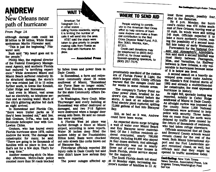
Some officials in Florida considered Andrew the worst storm in the state since the Labor Day hurricane in 1935.[41] Within Miami-Dade County alone, the storm destroyed about 25,524 homes and damaged 101,241 others. Additionally, 90% of mobile homes in the county were destroyed, while the destruction of 99% of mobile homes occurred in Homestead.[3] More than 50 streets were blocked by fallen trees and power lines.[42] Approximately 20 million cubic yards of debris left by the storm were disposed of.[43] Outside of Miami-Dade County, effects were relatively minimal, except in Broward, Monroe, and Collier counties. In Broward County, property damage reached about $100 million and three fatalities were reported.[3] In addition to the damage at Everglades National Park, effects in Monroe County were significant, especially in the Upper Florida Keys. Strong winds damaged billboards, awnings, commercial signs, several boats, planes, trees,[44] and 1,500 homes, with 300 of those becoming uninhabitable.[22] Damage in that county was about $131 million.[3] In Collier County, slight damage to houses occurred, with property losses reaching $30 million. Overall, Andrew caused 44 fatalities and $25.3 billion in damage (1992 USD, $42.7 billion 2016 USD) in Florida alone,[3] making it the costliest hurricane to hit the state.[45] Of the 44 deaths, 15 were direct fatalities, while 29 were indirectly caused by the storm. It was later noted that had the storm been slightly larger or made landfall a few miles further north, it would have significantly affected Miami and Fort Lauderdale, which would have resulted in an even higher damage and death toll.[3] An analysis by the American Meteorological Society indicated that unusual to most hurricanes, wind damage from Andrew was mostly north of the eyewall path and occurred primarily on the eastern edge of the storm.[46]
Louisiana
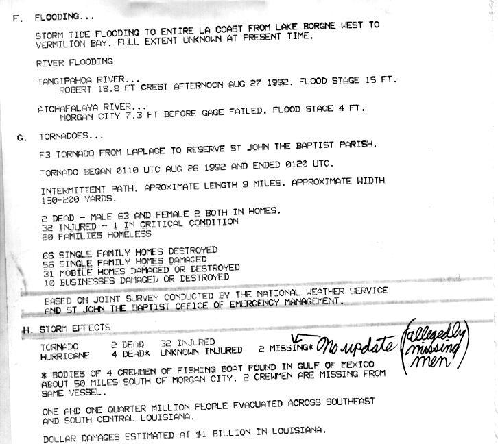
After hitting Florida, Andrew moved across the Gulf of Mexico and made landfall about 23 mi (37 km) west-southwest of Morgan City in south-central Louisiana; at landfall, the maximum sustained winds were 115 mph (185 km/h). As it moved ashore, the hurricane produced storm tides of at least 8 ft (2.4 m), causing flooding along the coast from Vermilion Bay to Lake Borgne.[3] River flooding was also reported, with the Tangipahoa River in Robert cresting at 3.8 ft (1.2 m) above flood stage.[47] Before making landfall, Andrew spawned an F3 tornado in Laplace, which killed two people and injuring 32.[3][47] The tornado was on the ground for about 10 minutes, during which it damaged or destroyed 163 structures, leaving 60 families homeless.[47] Collectively, 14 tornadoes were reported in the parishes of Ascension, Iberville, Pointe Coupee, and Avoyelles, as well as in Baton Rouge.[3][48] Heavy rains accompanied the storm's passage through the state, peaking at 11.02 in (280 mm) in Robert.[3][49] Elsewhere in the state, 9 fatalities and at least 75 injuries were reported. Offshore Louisiana, a group of six fishermen from Alabama perished due to drowning.[3][47][50][51]
Along the Louisiana coastline, damage largely resembled that of a Category 2 hurricane. Damage was heaviest in St. Mary Parish, about 32 mi (51 km) east of where Andrew made landfall. Hurricane-force winds damaged roofs, although most homes fared well during the storm, with the main exception being large trees falling onto houses. In Cypremort Point State Park, where winds were estimated at 90 mph (140 km/h), several mobile homes were destroyed.[52] Houses in the Morgan City, Patterson, and Berwick areas suffered minor damage, mainly limited to shingles being torn off; some large trees fell, causing severe damage to mobile homes. Similar damage was experienced further north in St. Mary Parish, in the towns of Franklin, Charenton, and Jeanerette, where mobile homes were toppled and debris from homes were scattered. At Port Fourchon, power lines were knocked down and a restaurant was unroofed, where winds were estimated to be between 80 and 85 mph (129 and 137 km/h). Damage was lighter in Jefferson Parish, where damage to mobile homes was reported and shingles were blown off, due to winds between 60 and 65 mph (97 and 105 km/h). The levee in the parish remained untouched.[53] Across the state, the hurricane damaged 23,000 homes and destroyed 985 homes and 1,951 mobile homes; private property damage was estimated at $1 billion. The high winds destroyed large areas of sugar and soybean crops, estimated at $289 million in damage. During the storm's passage, upwelling occurred in the Atchafalaya Basin and Bayou Lafourche, killing 187 million freshwater fish. Damage to the fishing industry was estimated at $266 million. Overall, losses in the state of Louisiana reached approximately $1.56 billion.[48]
Remainder of United States
While Andrew was entering the Gulf of Mexico, oil companies evacuated hundreds of employees from offshore drilling platforms.[54] The storm damaged 240 oil and gas facilities off the coast of Louisiana.[48] Overall, Hurricane Andrew caused about $500 million in damage to oil facilities. One company reported 13 platforms lost, 104 structures damaged, and five drilling wells blown off course.[3]
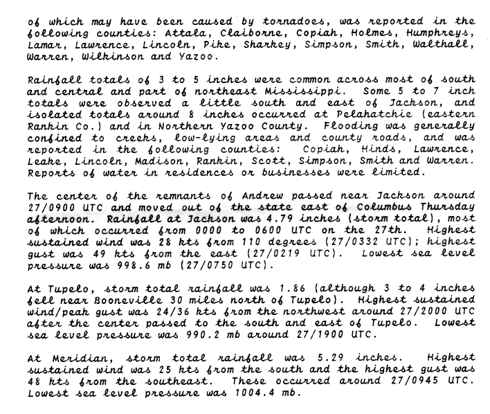
As Andrew moved ashore in Louisiana, its outer fringes produced a storm tide of about 1.3 ft (0.40 m) in Sabine Pass, Texas. Winds were minor in the state, reaching 30 mph (48 km/h) in Port Arthur.[3] After moving through Louisiana, Tropical Storm Andrew crossed Mississippi, prompting 3 severe thunderstorm warnings, 21 tornado warnings, and 16 flood warnings. Funnel clouds were observed near the path of the storm,[55] along with 26 tornadoes.[56] Structural damage was generally minimal, occurring from the tornadoes and severe thunderstorms. Strong winds knocked down trees in the southwestern portion of the state.[55] The storm dropped rainfall across much of the state,[57] peaking at 9.30 in (236 mm) at Sumrall.[49]
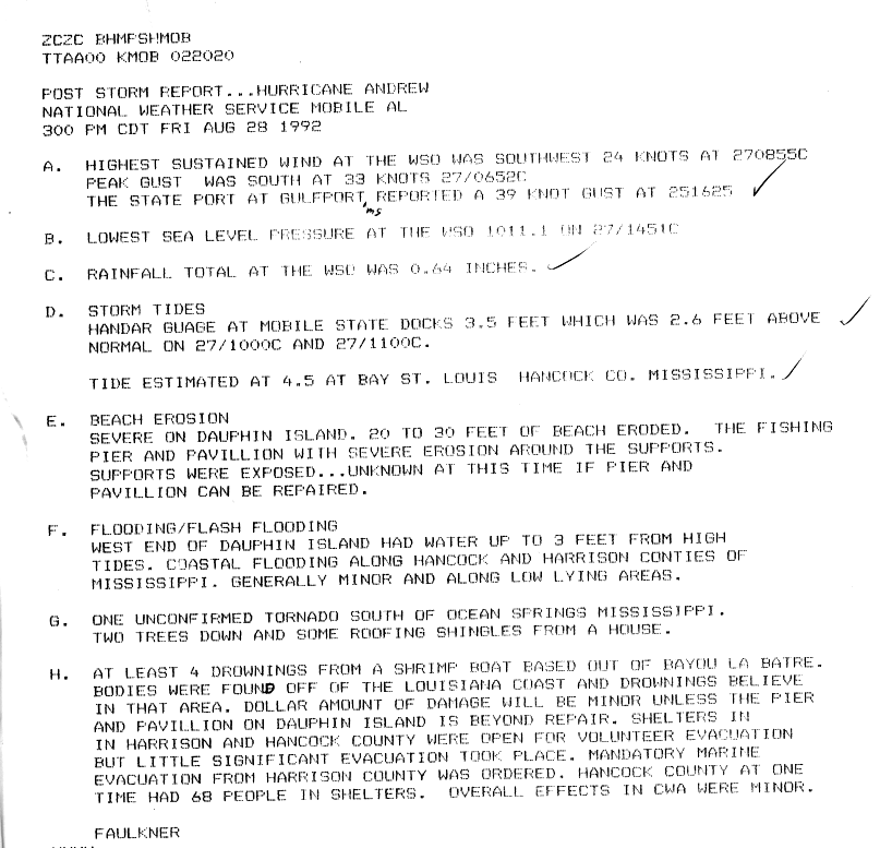
In Alabama, rainfall caused flooding in low-lying areas and creeks, covering a few county roads but not entering many houses or businesses.[57] Along the coast, the storm produced flooding and high tides.[50] Along Dauphin Island, high tides left severe beach erosion, with up to 30 ft (9.1 m) lost in some areas.[50] Precipitation amounts in the state peaked at 4.71 in (120 mm) in Aliceville.[49] Two damaging tornadoes occurred in the state, and wind gusts of 41 mph (67 km/h) were reported in Huntsville.[3] Damage was generally minor in Alabama.[50]
Tropical storm force wind gusts and damaging tornadoes extended eastward into Georgia. Monetary losses in the state reached about $100,000.[3] Rainfall from Andrew spread across the southeastern United States along the Appalachian Mountains corridor; totals of over 5 inches (125 mm) were reported near the tri-point border between Georgia, South Carolina, and North Carolina. Rainfall continued along the path of Andrew's remnants through the Mid-Atlantic and Ohio Valley, with precipitation measured as far north as Upstate New York.[15]
Aftermath
Initially, the Bahamas National Disaster Coordinator believed that foreign aid was not required. However, shortly after the storm, the Government of the United Kingdom began distributing blankets, food, ice, and water. HMS Cardiff, a Royal Navy Type 42 destroyer, was the operational guard ship at the time and assisted in relief operations in and around the Gregorytown area.[31][58] In addition, assistance came from Canada, Japan, and the United States, as well as the United Nations. The American Red Cross delivered 100 tents, 100 rolls of plastic sheeting, and 1,000 cots.[31] In Florida, then-President of the United States George H. W. Bush assessed damage in the Miami area with then-Governor of Florida Lawton Chiles. Shortly thereafter, Bush declared the region a disaster area, which provided public assistance to victims of the storm [41] in Broward, Collier, Miami-Dade, and Monroe Counties.[59] Then-Lieutenant Governor of Florida Buddy MacKay flew over the impact area and described the scene as looking "like a war zone".[60] Governor Chiles considered asking the Florida State Legislature to raise taxes, stating that "No matter how much Congress appropriates to repair damage from Hurricane Andrew, the state will face a substantial cleanup bill". In September 1992, President Bush initially proposed a $7.1 billion aid package to provide disaster benefits, small-business loans, agricultural recovery, food stamps, and public housing for victims of Hurricane Andrew.[61] After the United States House of Representatives appropriated aid to victims of Hurricane Iniki in Hawaii and Typhoon Omar in Guam, the cost was later increased to $11.1 billion. The bill, which was the most costly disaster aid package at the time, was passed by Congress as House Resolution 5620 on September 18,[62] and signed into law by President Bush on September 23.[63]
![[60]](#cite_note-dn0827p2.gif-63)
Crime, especially looting and theft, rose sharply in the areas south of Miami immediately after Andrew. Reports indicate that merchandise was stolen at a number of damaged or destroyed shopping centers in southern Miami-Dade County. Additionally, looting occurred in neighborhoods severely affected by the storm, regardless of the how few of the owners possessions remained.[64][65] Initially, the slow response of federal aid prompted Dade County Emergency Management Director Kate Hale to famously exclaim at a nationally televised news conference, "Where in the hell is the cavalry on this one? They keep saying we're going to get supplies. For God's sake, where are they?" Almost immediately, President Bush promised, "Help is on the way," and mobile kitchens, food, and tents, along with over 20,000 units from the Florida Army National Guard (124th Infantry Regiment from Florida); the 24th Infantry Division from Fort Wainwright, the 82nd Airborne Division in Fort Bragg, and the 10th Mountain Division from Fort Drum.[66][67] In order to provide temporary housing for the homeless, military personnel set up six tent cities, five in Florida City and Homestead, with an additional one later opened at the Miccosukee Indian Reservation.[68][69]
The storm struck Florida in the midst of 1992 presidential election campaign. A poll conducted by CBS News in September showed that 65% of Miami-Dade County residents approved of Bush's handling of the disaster, while 61% of approved statewide. Despite the support of Bush's response and his proposal to rebuild Homestead Air Force Base, he benefited little politically and trailed 48%-42% against Bill Clinton in another poll taken in September. Additionally, 75% of voters in Miami-Dade County and 82% of Floridians overall stated that the president's actions in response to Andrew would not impact their vote in November.[70] Bush went on to carry the state of Florida, but by a margin of only 1.89%.
In the aftermath of the storm, extensive psychological effects were reported. Difficulty during clean-up and recovery lead to increased divorce rates and a spike in Posttraumatic stress disorder (PTSD). The cases of PTSD primarily impacted children. A sampling of 378 adolescents by the University of South Carolina's Department of Epidemiology and Biostatistics indicated that 3% of males and 9% of females met the criteria for PTSD.[71] Dozens of children in the area attempted suicide, while counselors reported that between 50 and 60 children discussed killing themselves between December 1992 and January 1993.[72]
More than 930,000 policyholders in South Florida lost coverage after 11 insurance companies went bankrupt, caused by more than 600,000 insurance claims filed. This led the Florida Legislature to create new entities, such as the Joint Underwriting Association, the Florida Windstorm Underwriting Association, and the Florida Hurricane Catastrophe Fund, in effort to restore adequate insurance capacity.[73] Stricter building codes were created in Florida in the aftermath of Hurricane Andrew. In July 1996, Governor Chiles established the Florida Building Codes Study Commission, with the purpose of assessing the buildings codes at the time, as well as enacting improvements and reform to the system. The commission study indicated that building codes and regulations were developed, amended, and administered by over 400 local jurisdictions and state agencies.[74]
In 1998, the Florida Building Code was established and put into effect by 2002.[75] It phased out local laws and regulations and replacing them with universal statewide building codes. After hurricanes Charley, Frances, Ivan, and Jeanne in 2004, a study conducted by the University of Florida in the following year noted that "Homes built under the new Florida Building Code that became effective in 2002 sustained less damage on average than those built between 1994 and 2001." A report by the Florida Legislature in 2006 after Hurricanes Dennis, Katrina, and Wilma in 2005 came to a similar conclusion, indicating that "they added further evidence that the Florida Building Code is working."[76]
On August 26, George H. W. Bush toured devastated areas of Louisiana with Governor Edwin Edwards.[77] President Bush remarked, "The destruction from this storm goes beyond anything we have known in recent years," but noted that damage was less severe than in Florida. After his visit to Louisiana, President Bush declared only Terrebonne Parish as a disaster area,[78] but later included 34 other parishes under this declaration.[79] 1,300 National Guardsmen were deployed to southern Louisiana. In early September, officials announced that 1,400 mobile homes, homes, and apartments would become available to residents whose dwellings became uninhabitable.[80] H.R. 5620 also included disaster aid to the state of Louisiana.[62][63]
Retirement
After the season had ended, the World Meteorological Organization's RA IV Hurricane Committee retired the name Andrew from the Atlantic tropical cyclone naming lists and replaced it with Alex.[81][82] The name Andrew will never again be used for an Atlantic hurricane.
Notes
References
- 1 2 National Hurricane Center; Hurricane Research Division (July 6, 2016). "Atlantic hurricane best track (HURDAT version 2)". United States National Oceanic and Atmospheric Administration. Retrieved December 8, 2016.
- 1 2 National Hurricane Center; Hurricane Research Division; Atlantic Oceanographic and Meteorological Laboratory (February 2015). "Continental United States Hurricanes (Detailed Description)". aoml.noaa.gov. Miami: United States National Oceanic and Atmospheric Administration's Office of Oceanic & Atmospheric Research. Retrieved December 8, 2016.
- 1 2 3 4 5 6 7 8 9 10 11 12 13 14 15 16 17 18 19 20 21 22 23 24 25 26 27 28 29 30 31 32 33 34 35 36 Edward Rappaport (1993-12-10). Hurricane Andrew. National Hurricane Center (Preliminary Report). Miami, Florida: United States National Oceanic and Atmospheric Administration's National Weather Service. Retrieved 2012-06-21.
- ↑ Max Mayfield (1992-08-17). Tropical Depression Three Discussion One (TXT). National Hurricane Center (Report). Hurricane Andrew, Hurricane Wallet Digital Archives. Miami, Florida: United States National Oceanic and Atmospheric Administration's National Weather Service. Retrieved 2012-06-21.
- ↑ Edward Rappaport (1992-08-18). Tropical Storm Andrew Discussion Five (TXT). National Hurricane Center (Report). Hurricane Andrew, Hurricane Wallet Digital Archives. Miami, Florida: United States National Oceanic and Atmospheric Administration's National Weather Service. Retrieved 2012-06-21.
- ↑ Harold Gerrish (1992-08-18). Tropical Storm Andrew Discussion Eight (TXT). National Hurricane Center (Report). Hurricane Andrew, Hurricane Wallet Digital Archives. Miami, Florida: United States National Oceanic and Atmospheric Administration's National Weather Service. Retrieved 2012-05-08.
- ↑ Miles Lawrence (1992-08-20). Tropical Storm Andrew Discussion Thirteen (TXT). National Hurricane Center (Report). Hurricane Andrew, Hurricane Wallet Digital Archives. Miami, Florida: United States National Oceanic and Atmospheric Administration's National Weather Service. Retrieved 2012-06-21.
- ↑ Max Mayfield (1992-08-21). Tropical Storm Andrew Discussion Twenty (TXT). National Hurricane Center (Report). Hurricane Andrew, Hurricane Wallet Digital Archives. Miami, Florida: United States National Oceanic and Atmospheric Administration's National Weather Service. Retrieved 2012-06-21.
- ↑ Max Mayfield (1992-08-22). Hurricane Andrew Discussion Twenty-Three (TXT). National Hurricane Center (Report). Hurricane Andrew, Hurricane Wallet Digital Archives. Miami, Florida: United States National Oceanic and Atmospheric Administration's National Weather Service. Retrieved 2012-06-21.
- 1 2 3 4 5 6 7 Christopher Landsea, James Franklin, Colin McAdie, John Beven II, James Gross, Brain Jarvinen, Richard Pasch, Edward Rappaport, Jason Dunion, Peter Dodge; Franklin; McAdie; Beven; Gross; Jarvinen; Pasch; Rappaport; Dunion; Dodge (November 2004). "A Re-Analysis of Hurricane Andrew's Intensity" (PDF). Bulletin of the American Meteorological Society. Miami, Florida: American Meteorological Society. 85 (11): 1707–1708. Bibcode:2004BAMS...85.1699L. doi:10.1175/BAMS-85-11-1699. Retrieved 2012-06-22.
- ↑ Max Mayfield (1992-08-23). Hurricane Andrew Discussion Thirty (TXT). National Hurricane Center (Report). Hurricane Andrew, Hurricane Wallet Digital Archives. Miami, Florida: United States National Oceanic and Atmospheric Administration's National Weather Service. Retrieved 2012-06-21.
- ↑ Christopher Landsea (2009-08-20). Aren't big tropical cyclones also intense tropical cyclones?. Atlantic Oceanographic and Meteorological Laboratory (Report). Miami, Florida: United States National Oceanic and Atmospheric Administration's National Weather Service. Retrieved 2012-06-21.
- ↑ Edward Rappaport; Harold Gerrish; Richard Pasch (1992-08-24). Hurricane Andrew Discussion Thirty-One (TXT). National Hurricane Center (Report). Hurricane Andrew, Hurricane Wallet Digital Archives. Miami, Florida: United States National Oceanic and Atmospheric Administration's National Weather Service. Retrieved 2012-06-21.
- ↑ Lixion Avila; Max Mayfield (1992-08-24). Hurricane Andrew Discussion Thirty-Five (TXT). National Hurricane Center (Report). Hurricane Andrew, Hurricane Wallet Digital Archives. Miami, Florida: United States National Oceanic and Atmospheric Administration's National Weather Service. Retrieved 2012-06-21.
- 1 2 3 David Roth (2007-05-02). "Hurricane Andrew – August 23–28, 1992". Tropical Cyclone Point Maxima Rainfall Data. Weather Prediction Center (Report). College Park, Maryland: United States National Oceanic and Atmospheric Administration's National Weather Service. Retrieved 2012-06-21.
- ↑ Max Mayfield (1992-08-23). Hurricane Andrew Public Advisory Thirty (TXT). National Hurricane Center (Report). Hurricane Andrew, Hurricane Wallet Digital Archives. Miami, Florida: United States National Oceanic and Atmospheric Administration's National Weather Service. Retrieved 2012-05-08.
- 1 2 Jonathan Freedland (1992-09-02). "Storm Ravaged Island in Bahamas". Washington Post. Washington D.C. Retrieved 2008-12-08.
- ↑ Harold Gerrish; National Hurricane Center (1992-08-23). Hurricane Andrew Special Advisory Number Twenty-Seven (TXT) (Report). United States National Oceanic and Atmospheric Administration's National Weather Service. Retrieved 2012-05-08.
- ↑ Edward Rappaport; Richard Pasch; Harold Gerrish (1992-08-24). Hurricane Andrew Advisory Number Thirty-One (TXT). National Hurricane Center (Report). Miami, Florida: United States National Oceanic and Atmospheric Administration's National Weather Service. Retrieved 2012-05-08.
- ↑ Lee County Department of Public Services. Hurricane Andrew Fact Sheet (GIF). National Hurricane Center (Report). Hurricane Andrew, Hurricane Wallet Digital Archives. Fort Myers, Florida: United States National Oceanic and Atmospheric Administration's National Weather Service. Retrieved 2012-05-08.
- 1 2 "Storm: Andrew could be strongest" (GIF). Detroit Free Press. Hurricane Andrew, Hurricane Wallet Digital Archives. Miami, Florida: United States National Oceanic and Atmospheric Administration's National Weather Service and National Hurricane Center. 1992-08-26. Retrieved 2012-05-08.
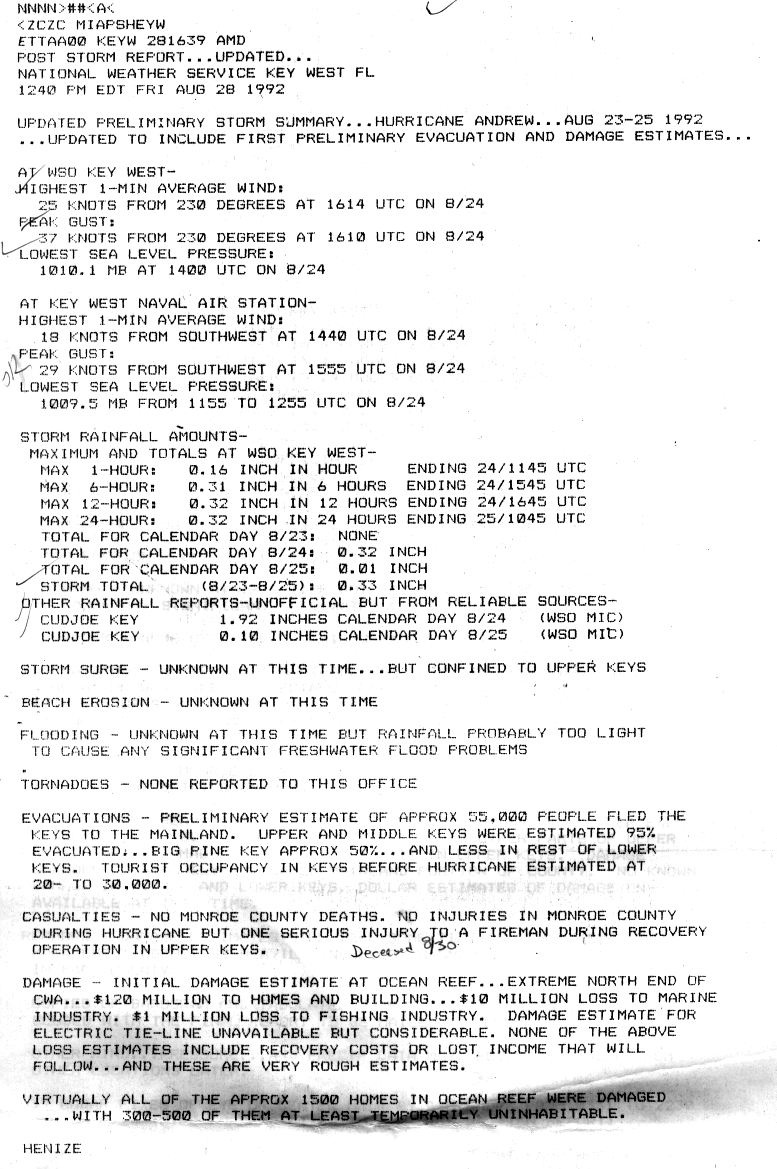
- 1 2 Dennis Henize (1992-08-30). Hurricane Andrew Post Storm Report (GIF). National Weather Service Key West, Florida (Report). Hurricane Andrew, Hurricane Wallet Digital Archives. Key West, Florida: National Hurricane Center. Retrieved 2012-05-08.
- ↑ Blake, Eric S; Landsea, Christopher W; Gibney, Ethan J; National Climatic Data Center; National Hurricane Center (August 10, 2011). The deadliest, costliest and most intense United States tropical cyclones from 1851 to 2010 (and other frequently requested hurricane facts) (PDF) (NOAA Technical Memorandum NWS NHC-6). National Oceanic and Atmospheric Administration. p. 47. Retrieved August 10, 2011.
- ↑ Blake, Eric S; Kimberlain, Todd B; Berg, Robert J; Cangialosi, John P; Beven II, John L; National Hurricane Center (February 12, 2013). Hurricane Sandy: October 22 – 29, 2012 (PDF) (Tropical Cyclone Report). United States National Oceanic and Atmospheric Administration's National Weather Service. Archived from the original on February 17, 2013. Retrieved February 17, 2013.
- ↑ Hurricane/Post-Tropical Cyclone Sandy, October 22–29, 2012 (PDF) (Service Assessment). United States National Oceanic and Atmospheric Administration's National Weather Service. May 2013. p. 10. Archived from the original on June 2, 2013. Retrieved June 2, 2013.
- ↑ "Biggest Hurricanes in Cyclone World Storm History". Newsoxy. Retrieved May 26, 2014.
- ↑ Eric Blake; Christopher Landsea; Ethan Gibney (2011-08-10). The deadliest, costliest and most intense United States tropical cyclones from 1851 to 2010 (and other frequently requested hurricane facts) (PDF). National Hurricane Center (NOAA Technical Memorandum NWS NHC-6). Miami, Florida: United States National Oceanic and Atmospheric Administration's National Weather Service. p. 47. Retrieved 2011-08-10.
- ↑ Arthur Rolle (1992-10-30). Hurricane Andrew in the Bahamas (GIF) (Report). Hurricane Andrew, Hurricane Wallet Digital Archives. Nassau, Bahamas: United States National Oceanic and Atmospheric Administration's National Weather Service and National Hurricane Center. p. 2. Retrieved 2008-10-11.
- ↑ Edward Rappaport (2005-02-07). Hurricane Andrew Report Addendum. National Hurricane Center (Report). Hurricane Andrew, Hurricane Wallet Digital Archives. Miami, Florida: United States National Oceanic and Atmospheric Administration's National Weather Service. Retrieved 2012-05-08.
- 1 2 Arthur Rolle (1992-10-30). Hurricane Andrew in the Bahamas (GIF). National Hurricane Center (Report). Hurricane Andrew, Hurricane Wallet Digital Archives. Nassau, Bahamas: United States National Oceanic and Atmospheric Administration's National Weather Service. p. 4. Retrieved 2008-10-12.
- 1 2 3 4 5 Bahamas and U.S.A. – Hurricane Andrew Aug 1992 UN DHA Information Reports 1-3. United Nations Department of Humanitarian Affairs (Report). New York City, New York: ReliefWeb. 1992-08-26. Retrieved 2012-06-20.
- 1 2 Arthur Rolle (1992-10-30). Hurricane Andrew in the Bahamas (GIF). National Hurricane Center (Report). Hurricane Andrew, Hurricane Wallet Digital Archives. Nassau, Bahamas: United States National Oceanic and Atmospheric Administration's National Weather Service. p. 3. Retrieved 2008-10-11.
- ↑ Edwin McDowell (1992-09-27). "After the storms: Three reports; Bahamas". New York Times. New York City, New York. Retrieved 2008-12-18.
- ↑ "Andrew hits with horrific vengeance" (GIF). The News-Sentinel. Hurricane Andrew, Hurricane Wallet Digital Archives. Miami, Florida: United States National Oceanic and Atmospheric Administration's National Weather Service and National Hurricane Center. Associated Press. 1992-08-24. p. 2. Retrieved 2012-06-22.
- ↑ 20th Anniversary of Hurricane Andrew (Report). Earth Sky. Retrieved June 14, 2014.
- 1 2 "Hurricane Facts". Sarasota Herald-Tribune. Sarasota, Florida. 1994-09-24. Retrieved 2012-05-09.
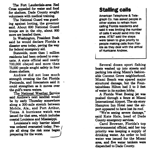
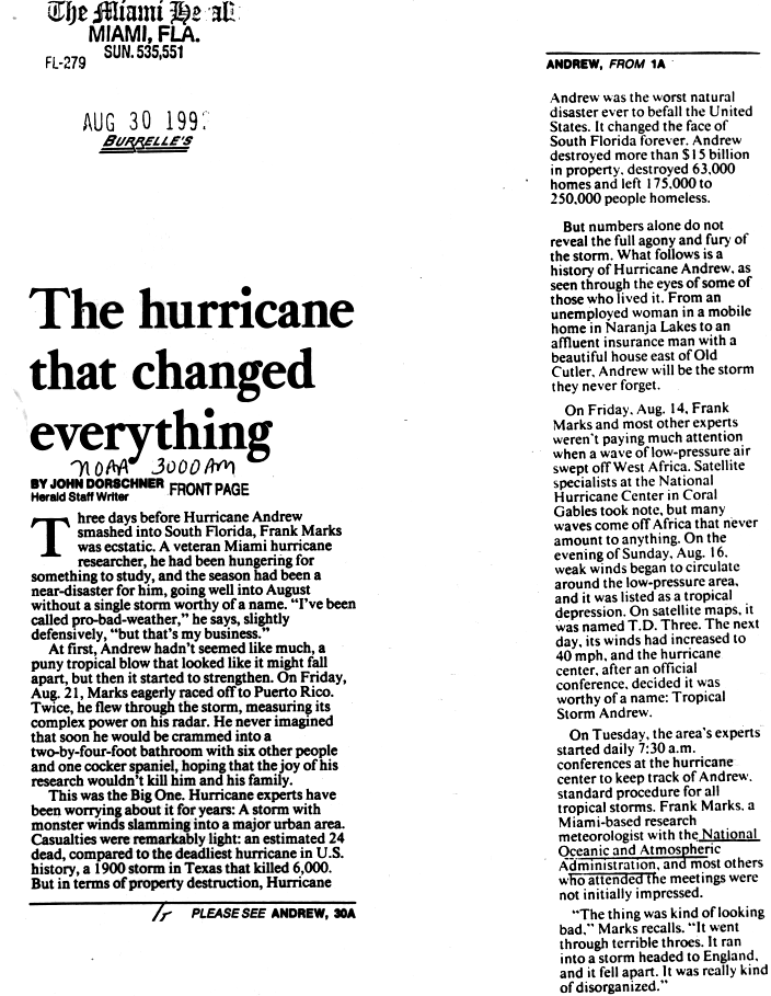
- ↑ John Dorschner (1992-08-30). "The hurricane that changed everything" (GIF). The Miami Herald. Hurricane Andrew, Hurricane Wallet Digital Archives. Miami, Florida: United States National Oceanic and Atmospheric Administration's National Weather Service and National Hurricane Center. p. 1. Retrieved 2012-05-09.
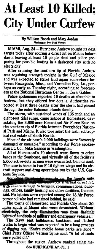
- ↑ William Booth; Mary Jordan (1992-08-25). "At Least 10 Killed; City Under Curfew" (GIF). The Washington Post. Hurricane Andrew, Hurricane Wallet Digital Archives. United States National Oceanic and Atmospheric Administration's National Weather Service and National Hurricane Center. p. 1. Retrieved 2012-05-09.
- ↑ "Debartolo Rebuilding Damaged Fla. Mall". The Vindicator. Youngstown, Ohio. 1992-08-31. Retrieved 2012-05-09.
- ↑ John Lovelace; Benjamin McPherson (1998-06-24). Effects of Hurricane Andrew (1992) on Wetlands in Southern Florida and Louisiana (Report). Reston, Virginia: United States Geological Survey. Retrieved 2012-05-09.
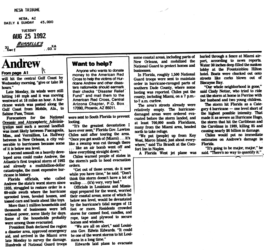
- 1 2 "Andrew aims for Gulf Coast" (GIF). Mesa Tribune. Hurricane Andrew, Hurricane Wallet Digital Archives. Mesa, Arizona: United States National Oceanic and Atmospheric Administration's National Weather Service and National Hurricane Center. 1992-08-25. p. 2. Retrieved 2012-05-09.
- ↑ Mark Silva; Charles Strouse; John Donnelly (1992-08-25). "Floridians mop up; Gulf Coast is next" (GIF). Knight Ridder. Hurricane Andrew, Hurricane Wallet Digital Archives. Miami, Florida: United States National Oceanic and Atmospheric Administration's National Weather Service and National Hurricane Center. p. 1. Retrieved 2012-06-01.
- ↑ David Godschalk; Timothy Beatley; Philip Berke; David Brower; Edward Kaiser (1999). Natural hazard mitigation: recasting disaster policy and planning. Washington D.C.: Island Press. p. 114. ISBN 1-55963-602-5. Retrieved 2012-06-01.
- ↑ Dan Keating; Nancy Klingener (1992-08-27). "Keys are islands in every sense after Andrew" (GIF). The Miami Herald. Hurricane Andrew, Hurricane Wallet Digital Archives. Miami, Florida: United States National Oceanic and Atmospheric Administration's National Weather Service and National Hurricane Center. Retrieved 2011-12-06.
- ↑ Matt Reed (February 10, 2010). "Changes in wind for hurricane insurance discounts calculators". Florida Today (Column). Melbourne, Florida. Retrieved September 30, 2015.
- ↑ Roger Wakimoto; Peter Black (February 1994). "Damage Survey of Hurricane Andrew and Its Relationship to the Eyewall". Bulletin of the American Meteorological Society. Boston, Massachusetts: American Meteorological Society. 75 (2): 199. Bibcode:1994BAMS...75..189W. doi:10.1175/1520-0477(1994)075<0189:DSOHAA>2.0.CO;2. ISSN 1520-0477.
- 1 2 3 4 Final Storm Report ... Hurricane Andrew ... Corrected (GIF). National Hurricane Center (Report). Hurricane Andrew, Hurricane Wallet Digital Archives. New Orleans, Louisiana: United States National Oceanic and Atmospheric Administration's National Weather Service. 1992-09-15. p. 2. Retrieved 2011-05-10.
- 1 2 3 Grant Goodge. Storm Data Excerpt for Hurricane Andrew – August 1992 (PDF) (Report). Asheville, North Carolina: National Climatic Data Center. pp. 31–35. Retrieved 2012-03-26.
- 1 2 3 David Roth (2011-09-21). "Tropical Cyclone Rainfall for the Gulf Coast". Tropical Cyclone Rainfall Data. Camp Springs, Maryland: Weather Prediction Center. Retrieved 2013-04-02.
- 1 2 3 4 Faulkner (1992-08-28). Post Storm Report ... Hurricane Andrew (GIF). National Hurricane Center (Report). Hurricane Andrew, Hurricane Wallet Digital Archives. Mobile, Alabama: United States National Oceanic and Atmospheric Administration's National Weather Service. National Weather Service Mobile, Alabama. Retrieved 2011-03-29.
- ↑ "Louisiana Hit Hard By Hurricane Andrew". New Straits Times. New Orleans, Louisiana. Associated Press. 1992-08-27. Retrieved 2012-03-18.
- ↑ Michael Koziara (1992-09-10). Hurricane Andrew Damage Assessment (GIF). National Hurricane Center (Report). Hurricane Andrew, Hurricane Wallet Digital Archives. New Orleans, Louisiana: United States National Oceanic and Atmospheric Administration's National Weather Service. p. 1. Retrieved 2011-11-18.
- ↑ Michael Koziara (1992-09-10). Hurricane Andrew Damage Assessment (GIF). National Hurricane Center (Report). Hurricane Andrew, Hurricane Wallet Digital Archives. New Orleans, Louisiana: United States National Oceanic and Atmospheric Administration's National Weather Service. p. 2. Retrieved 2011-11-23.
- ↑ Alan Sayre (1992-08-25). "State" (GIF). The Town Talk. Hurricane Andrew, Hurricane Wallet Digital Archives. New Orleans, Louisiana: United States National Oceanic and Atmospheric Administration's National Weather Service and National Hurricane Center. Associated Press. p. 2. Retrieved 2012-05-08.
- 1 2 Steve Rich (1992-09-03). Tropical Storm Andrew (GIF). National Hurricane Center (Report). Hurricane Andrew, Hurricane Wallet Digital Archives. Jackson, Mississippi: United States National Oceanic and Atmospheric Administration's National Weather Service. National Weather Service Jackson, Mississippi. p. 1. Retrieved 2011-03-27.
- ↑ A Look Back at Hurricane Rita. National Weather Service Jackson, Mississippi (Report). Jackson, Mississippi: National Oceanic and Atmospheric Administration. 2010-09-22. Retrieved 2011-03-27.
- 1 2 Steve Rich (1992-09-03). Tropical Storm Andrew (GIF). National Hurricane Center (Report). Hurricane Andrew, Hurricane Wallet Digital Archives. Jackson, Mississippi: United States National Oceanic and Atmospheric Administration's National Weather Service. National Weather Service Jackson, Mississippi. p. 2. Retrieved 2011-03-27.
- ↑ Jonathan Freedland (1992-09-02). "Storm Ravaged Island in Bahamas". Washington Post. Nassau, Bahamas. Retrieved 2012-06-20.
- ↑ Florida Hurricane Andrew (DR-955). United States Department of Homeland Security (Report). Federal Emergency Management Agency's Archive of Declared Disasters & Emergencies. Washington D.C.: Federal Emergency Management Agency. 2004-10-18. Retrieved 2012-05-08.
- ↑ "Andrew picks up speed as it races across gulf" (GIF). Detroit Free Press. Hurricane Andrew, Hurricane Wallet Digital Archives. New Orleans, Louisiana: United States National Oceanic and Atmospheric Administration's National Weather Service and National Hurricane Center. 1992-08-27. Retrieved 2012-05-08.
- ↑ Alan Judd (1992-09-12). "Chiles hints at future tax hike". Gainesville Sun. Tallahassee, Florida. New York Times. Retrieved 2012-05-08.
- 1 2 Sean Holton (1992-09-19). "Disaster Aid Bill Goes To Bush". Orlando Sentinel. Washington D.C. Retrieved 2013-01-17.
- 1 2 "Bill Summary & Status 102nd Congress (1991–1992) H.R.5620". Washington D.C.: Library of Congress. Retrieved 2013-01-17.
- ↑ Craig Pittman (2002-08-18). "Storm's howl fills the ears of survivors". St. Petersburg Times. Homestead, Florida. Retrieved 2012-05-10.
- ↑ Larry Rohter (1992-08-26). "Hurricane Andrew; Down to the Basics: Hunting For Food, Water and Shelter". New York Times. New York City, New York.
- ↑ Bill Adair (2002-08-20). "10 years ago, her angry plea got hurricane aid moving". St. Petersburg Times. Homestead, Florida. Retrieved 2012-05-08.
- ↑ Jeffrey Ulbrich (1992-09-08). "82nd Airborne savors 'helping our own'". Gainesville Sun. Miami, Florida. Associated Press. Retrieved 2015-08-24.
- ↑ "Only 300 People Go To Tent Cities". Eugene Register-Guard. Homestead, Florida. Associated Press. 1992-09-04. Retrieved 2012-05-10.
- ↑ Michael Fleeman (1992-09-08). "After Andrew Hurricane Victims Fill Tent Cities". The Free Lance–Star. Homestead, Florida. Associated Press. Retrieved 2012-05-10.
- ↑ Larry Rohter (1992-09-17). "THE 1992 CAMPAIGN: Florida Poll; Florida Emerges As Crucial State In the Campaign". Miami, Florida: The New York Times. Retrieved 2015-08-24.
- ↑ Garrison, CZ; C. Garrison, E. Bryant, C. Addy, P. Spurrier, J. Freedy, D. Kilpatrick (September 1995). "Posttraumatic stress disorder in adolescents after Hurricane Andrew". J Am Acad Child Adolesc Psychiatry. Columbia, South Carolina: United States National Library of Medicine. 34 (9): 1193–201. doi:10.1097/00004583-199509000-00017. PMID 7559314.
- ↑ Eugene Provenzo, Jr. (1995). Hurricane Andrew, the Public Schools, and the Rebuilding of Community. Albany, New York: State University of New York Press. p. 56. ISBN 1-4384-1652-0. Retrieved 2013-04-03.
- ↑ Adrian Sainz (2002-08-24). "Ten years after Hurricane Andrew, effects are still felt". South Florida Sun-Sentinel. Miami, Florida. Associated Press. Retrieved 2012-05-08.
- ↑ "Unified Florida Code Better for Business". SPRI. Retrieved 2013-03-31.
- ↑ Robert Cox; R. Raymond Issa; Jessica Ligator (June 2006). Top Ten Florida Residential Building Code Violations (PDF). University of Florida (Report). Gainesville, Florida: Florida Department of Business and Professional Regulation. p. vi. Retrieved 2013-03-31.
- ↑ Dominic Sims (2012-08-21). "Strong building codes work only if they are enforced". Sun-Sentinel. Retrieved 2013-03-31.
- ↑ "Photos: On this day – August 24, 1992 – Hurricane Andrew demolishes South Florida". New Haven Register. New Haven, Connecticut. 2012-08-24. Retrieved 2013-02-03.
- ↑ Peter Applebome (1992-08-27). "Hurricane Andrew; Hurricane Rips Louisiana Coast Before Dying Out". New York Times. New York City, New York. Retrieved 2012-05-08.
- ↑ Louisiana Hurricane Andrew (DR-956). Federal Emergency Management Agency (Report). Federal Emergency Management Agency's Archive of Declared Disasters & Emergencies. Washington D.C.: United States Department of Homeland Security. 2004-10-18. Retrieved 2012-01-17.
- ↑ "Rain plagues storm victims". Telegraph Herald. Miami, Florida. Associated Press. 1992-09-04. p. 13. Retrieved 2013-02-03.
- ↑ John (Jack) Beven II (1997-03-17). Worldwide Tropical Cyclone Names 1996–2001. National Hurricane Center (Report). Miami, Florida: United States National Oceanic and Atmospheric Administration's National Weather Service. Archived from the original on 2012-06-22. Retrieved 2012-06-22.
- ↑ National Hurricane Center (2012-04-13). Tropical Cyclone Naming History and Retired Names (Report). Miami, Florida: United States National Oceanic and Atmospheric Administration's National Weather Service. Archived from the original on 2012-06-22. Retrieved 2012-06-22.
External links
- Monthly Weather Review – Atlantic hurricane season of 1992
- National Hurricane Center's archive on Hurricane Andrew
| Wikimedia Commons has media related to Hurricane Andrew. |
| 1920s | |
|---|---|
| 1930s | |
| 1950s | |
| 1960s | |
| 1970s | |
| 1980s | |
| 1990s | |
| 2000s | |
| 2010s | |
| |
| 1950s | |
|---|---|
| 1960s | |
| 1970s | |
| 1980s | |
| 1990s | |
| 2000s | |
| 2010s | |
| |
Tropical cyclones of the 1992 Atlantic hurricane season | ||
|---|---|---|
 | ||
| ||