Eastern Docklands
| Oostelijk Havengebied | |
|---|---|
| Neighborhood of Amsterdam | |
 | |
 Location in Amsterdam | |
| Coordinates: 52°22′N 4°56′E / 52.367°N 4.933°ECoordinates: 52°22′N 4°56′E / 52.367°N 4.933°E | |
| Country |
|
| Province | North Holland |
| COROP | Amsterdam |
| Borough | Oost |
| Time zone | CET (UTC+1) |
The Eastern Docklands (Dutch: Oostelijk Havengebied) is a neighborhood of Amsterdam, Netherlands, located between the IJ and the Amsterdam–Rhine Canal in the borough of Amsterdam-Oost. The harbor area was constructed in the late nineteenth century to allow for increasing trade with the Dutch East Indies; a new location was necessitated by the construction of the Amsterdam Centraal railway station, which replaced the old quays. East of the new station was a marshy area called De Rietlanden, with the Zeeburgerdijk (then called Sint Antoniesdijk), running via the Zeeburch, a fort, to the Zuiderzee.
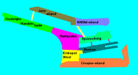
The neighborhood consists of the districts: KNSM Island, Java-eiland, Oostelijke Handelskade, Cruquiuseiland, Borneo-eiland and Sporenburg.[1]
The area, about 2/3 water and 1/3 land, consists of an extension of the Oostelijke Handelskade, east of the center of town, and four artificial "islands" (peninsulas), all of which were former industrial and harbor locations. In the early 2000s, after a large-scale reorganization, the city's biggest post-World War II building project, the Eastern Docklands was home to some 17,000 people living in some the highest population densities in the Netherlands.[2]
History
Construction
In the mid-nineteenth century the Dutch government determined that the city's open harbor front was to be filled in to allow for the construction of the Amsterdam Centraal railway station (the city decided on its location in 1869, and it was built 1882-1889), despite objections by the city; the building of the railway station followed necessarily on the Dutch government's decision in 1860 to build a national railroad system.[3] Also, because ship sizes had increased but the Amsterdam's docks had not, competition from other cities began to hurt the city economically; in 1860 Den Helder had overtaken Amsterdam in port activity.[3] To compensate for the loss of that harbor area and to create quays that would allow bigger ships to dock,[4] Amsterdam's city engineer, Jacobus van Niftrik, planned a new quay to the east of the station, the Oostelijke Handelskade. This quay was the start of the Eastern Docklands, which was developed contiguous to the already existing port area, the Spoorwegbassin, which would be used for the transloading of coal and iron ore; railroad tracks are already crisscrossing the area. Other decisions played a part in the construction of the area, such as the digging of the North Sea Canal, decided on in 1862.[3]
The development of the Oostelijke Handelskade (1876)[5] gave Amsterdam a deep-water harbor for the first time in its history, and warehouses such as Europa, Azië, and Africa jumpstart economic activity in 1883. The quay was designed according to modern requirements, with a railroad track and steam-powered cranes for loading and unloading.

Problematic was the influence of the Zuiderzee, which caused high waves and disturbed harbor activity. The city decides to build a breakwater, but this was unsuccessful, and in 1890 a dam was planned, the start of the future Java Island and KNSM Island. In 1896 the IJkade was constructed contiguous to the dam, and closed-in area raised with earth won from dredging the North Sea Canal, the digging of which had started in 1876.[5] When the western part of the IJkade was lengthened in 1904, a new peninsula was created, as well as two harbors: the water between the Java Island and the Oostelijke Handelskade is called the IJhaven, the water south of the KNSM Island is called the Ertshaven, both also connected by rail.
The deep-water harbors allowed for much economic development. In 1903, the Koninklijke Nederlandse Stoomboot-Maatschappij (KNSM) settled on the eastern part of the island and experienced rapid growth. On the western part, one of the occupants was the Stoomvaart Maatschappij Nederland (SMN), which had reached the limit of its possible expansion on the Oostelijke Handelskade. In the first half of the twentieth century there was ongoing development, including for instance the increasing transportation of passenger by ship to the Dutch East Indies, but after World War II harbor activity moved more to the city's Western Docklands[6] and in the 1960s, despite the coming of some new industries such as Mobil,[7] the area became less busy, due to the increase in container and the ever-increasing size of cargo ships.[4] In the 1970s, the area fell into complete disuse.[8]
Panorama

Recent development
In the 1980s, The city decided to change the by now derelict area into space for residences, and even proposed to fill in the harbors. In the end, the harbors and islands remained intact, to create relatively quiet enclaves of residential neighborhoods.[4]
Many of the homes in the Eastern Docklands attract young families, which has led to more families with young children staying in the city (rather than move to places like Almere, which offer more affordable family homes with gardens).[9][10] The area is also attractive to "trendy" and well-to-do urbanites;[11][12] the notably modern features of the new buildings in the "architecturally spectacular" area[13][14][15] draw in "trendy young media and IT professionals" and are a boon for tourism to the area.[16]
Oostelijke Handelskade

A central element in the development of the Docklands is the Oostelijke Handelskade, the Eastern Quay. Located on the IJ harbor, it ran along the docks to the east of the center of Amsterdam and got its name in 1883. Previously known as Handelskade, it was built between 1875 and 1883. In 1919 part of the quay was renamed Piet Hein Kade. In 2001, it became connected to Java Island by Jan Schaefer Bridge.
One of its characteristic buildings is the Lloyd Hotel, which was constructed in 1921 by Evert Breman as temporary housing for emigrants to Latin America, many of whom from Eastern Europe. During World War II it was used as a prison by the German occupiers, and after the war it retained that function. It became a prison for underage convicts in 1964. After 1989 it stood empty for a time, and in 1996 the city of Amsterdam opened a competition to turn the building into a hotel, a conversion, designed by Otto Nan, which was finished in 2004 (with 120 rooms).[17]
References
Literature
- Ton Heijdra, Kadraaiers & Zeekastelen: geschiedenis van het Oostelijk Havengebied. Amsterdam: Het Open Havenmuseum, 1993. ISBN 90-900570-1-3.
- Ton Heijdra, Zeeburg. Geschiedenis van de Indische Buurt en het Oostelijk Havengebied. Alkmaar: René de Milliano, 2000. ISBN 90-72810-32-5.
- Geert Mak & Frans Heddema (text), Han Singels (photography), De Eilanden. Het Amsterdams Oostelijk Havengebied in stadsgezichten 1974-2002. Amsterdam: De Verbeelding, 2002. ISBN 90-74159-45-1.
- Bert Franssen, Ruud van Soest, Ontdek het Oostelijk Havengebied. Amsterdam: Stokerkade cultuurhistorische uitgeverij, 2009, ISBN 978-90-79156-07-8.
Notes
- ↑ "Oostelijk Havengebied" Borough of Amsterdam East (in Dutch)
- ↑ Szita, Jane (April 2002). "Street of Dreams". Dwell: 62–69. Retrieved 19 May 2010.
- 1 2 3 Bosma, Koos (2000). Werken aan een open Amsterdam. Verloren. pp. 129–30. ISBN 978-90-6550-180-6.
- 1 2 3 Groenendijk, Paul; Piet Vollaard (2006). Architectuurgids Nederland: 1900-2000. 010 Publishers. pp. 308–309. ISBN 978-90-6450-573-7. Retrieved 19 May 2010.
- 1 2 Lebesque, Sabine (2006). Along Amsterdam's waterfront: exploring the architecture of Amsterdam's Southern IJ Bank. Valiz. p. 16. ISBN 978-90-78088-11-0.
- ↑ Bosma, Koos (2000). Werken aan een open Amsterdam. Verloren. p. 141. ISBN 978-90-6550-180-6.
- ↑ Reichwein, Onno (1998). J.M. den Uyl: gereformeerd af, socialist geworden, calvinist gebleven: de vormende jaren tijdens crisis- en oorlogstijd en de invloed daarvan op het naoorlogse politieke denken en handelen. Verloren. p. 97. ISBN 978-90-72131-39-3.
- ↑ Abrahamse, Jaap Evert (2003). Eastern Harbour District Amsterdam: urbanism and architecture. NAi. ISBN 978-90-5662-307-4.
- ↑ "Gezin rukt op binnen ring A-10, in de stad". Het Parool. 18 May 2010. Retrieved 18 May 2010.
- ↑ "Steeds meer jonge gezinnen in de stad". AT5. 18 May 2010. Retrieved 18 May 2010.
- ↑ "KNSM-eiland". Oostelijk Havengebied Amsterdam. Retrieved 17 May 2010.
- ↑ "Amsterdamse stadsdelen rollen rode loper uit voor toeristen". TourPRessHolland. Retrieved 18 May 2010.
- ↑ Haastrecht, Ruud van (4 October 1997). "Lonely Planet Amsterdam: suffe reisgids voor oudere jongeren". Trouw. Retrieved 18 May 2010.
- ↑ Mawer, Fred (17 September 2005). "Dockland chic in the city of canals". The Telegraph. Retrieved 17 May 2010.
- ↑ Roos, Robbert (30 April 1998). "Java-eiland en Borneo/Sporenburg: speeltuin voor architecten in het Oostelijk Havengebied". Trouw (in Dutch). Retrieved 17 May 2010.
- ↑ Trew, Jonathan (22 May 2004). "New Amsterdam". The Scotsman. Retrieved 18 May 2010.
- ↑ Kreulen, Edwin (19 August 2004). "Slapen in industrieel erfgoed". Trouw. Retrieved 17 May 2010.
Neighborhoods of Amsterdam | ||
|---|---|---|
| Centrum (Centre) | ||
| Nieuw-West (New West) | ||
| Noord (North) | ||
| Oost (East) |
| |
| West | ||
| Zuid (South) | ||
| Zuidoost (Southeast) |
| |
| Westpoort |
| |
Add'l. former boroughs: De Baarsjes - Geuzenveld-Slotermeer - Oost-Watergraafsmeer - Oud-West - Oud-Zuid - Slotervaart - Westerpark - Zeeburg - Zuideramstel | ||