Oologah, Oklahoma
| Oologah, Oklahoma | |
|---|---|
| Town | |
 Location of Oologah, Oklahoma | |
| Coordinates: 36°26′36.13″N 95°42′31.05″W / 36.4433694°N 95.7086250°WCoordinates: 36°26′36.13″N 95°42′31.05″W / 36.4433694°N 95.7086250°W | |
| Country | United States |
| State | Oklahoma |
| County | Rogers |
| Government | |
| • Mayor | Mat Shockley |
| • Board Members | Tod Estes, Melissa McKinney, Bill Josey, Cody Burch |
| • Clerk/Treasurer/Court Clerk | Holly Baker |
| Area | |
| • Total | 1.25 sq mi (3.24 km2) |
| • Land | 1.25 sq mi (3.24 km2) |
| • Water | 0.0 sq mi (0.0 km2) |
| Elevation | 656 ft (200 m) |
| Population (2010) | |
| • Total | 1,146 |
| • Density | 917.43/sq mi (354.22/km2) |
| Time zone | Central (CST) (UTC-6) |
| • Summer (DST) | CDT (UTC-5) |
| ZIP code | 74053 |
| Area code(s) | 539/918 |
| FIPS code | 40-55700[1] |
Oologah is a town in Rogers County, Oklahoma, United States. Renowned humorist Will Rogers was born on a ranch two miles east of Oologah, although he usually claimed Claremore as his birthplace "because nobody but an Indian can pronounce 'Oologah.'"[2] There has been disagreement about the proper spelling for the town name. The official spelling is now Oologah. It was often spelled Oolagah before statehood, and this spelling appears on some old buildings.[3]
History
In 1889, the Kansas and Arkansas Railway (later, the St. Louis, Iron Mountain and Southern Railway and finally, part of the Missouri Pacific Railroad) laid tracks through the area and established a townsite named Oologah, Indian Territory. Oologah was named for Oologah (Dark Cloud), a Cherokee chief.[4] The Encyclopedia of Oklahoma History and Culture says that the Oklahoma Federal Writers' Project claimed the name translates from the Cherokee as "red horse fish," while some other sources say that the name means "cloudy weather" or just "clouds."The post office was opened May 25, 1891.[5]
| Historical population | |||
|---|---|---|---|
| Census | Pop. | %± | |
| 1900 | 308 | — | |
| 1910 | 324 | 5.2% | |
| 1920 | 277 | −14.5% | |
| 1930 | 263 | −5.1% | |
| 1940 | 236 | −10.3% | |
| 1950 | 242 | 2.5% | |
| 1960 | 299 | 23.6% | |
| 1970 | 458 | 53.2% | |
| 1980 | 798 | 74.2% | |
| 1990 | 828 | 3.8% | |
| 2000 | 883 | 6.6% | |
| 2010 | 1,146 | 29.8% | |
| Est. 2015 | 1,179 | [6] | 2.9% |
Early in the 20th Century, the town flourished because of agriculture, coal mining, and oil and gas production. However, these were hard hit during the Great Depression. Town population declined from 324 in 1910 to 236 in 1940. The population had recovered to 299 in 1960. Construction of Oologah dam and lake in 1963, east of town, revitalized the town, which has continued to grow.[5]
In 1963, the Army Corps of Engineers completed the first phase of Oologah Lake.[5]
In 1991, an F4 tornado which was part of the Andover, Kansas tornado outbreak destroyed the north side of Oologah, including the town's school.
Geography
Oologah is located at 36°26′36″N 95°42′34″W / 36.44333°N 95.70944°W (36.443268, -95.709399).[7] According to the United States Census Bureau, the town has a total area of 1.25 square miles (3.2 km2), all of it land.
Demographics
As of the census[1] of 2010, there were 1,146 people and 481 households residing in the town. The population density was 917.43 people per square mile (354.22/km²). The racial makeup of the town was 76.4% White, 0.1% African American, 15.4% Native American, 1% Asian, .7% from other races, and 6% from two or more races. Hispanic or Latino of any race were 3.3% of the population. 69.3% of the population was over 18.
As of the 2000 census, there were 342 households out of which 42.1% had children under the age of 18 living with them, 52.0% were married couples living together, 18.4% had a female householder with no husband present, and 24.3% were non-families. 22.5% of all households were made up of individuals and 9.6% had someone living alone who was 65 years of age or older. The average household size was 2.58 and the average family size was 3.03.
In the town the population was spread out with 31.6% under the age of 18, 8.6% from 18 to 24, 27.7% from 25 to 44, 22.1% from 45 to 64, and 10.0% who were 65 years of age or older. The median age was 33 years. For every 100 females there were 89.9 males. For every 100 females age 18 and over, there were 84.1 males.
The median income for a household in the town was $33,977, and the median income for a family was $40,625. Males had a median income of $37,500 versus $25,000 for females. The per capita income for the town was $16,493. About 7.5% of families and 9.8% of the population were below the poverty line, including 14.7% of those under age 18 and 6.9% of those age 65 or over.
Education
Oologah-Talala Public Schools has a 4A sized high school. The Oologah Lower Elementary is an "Oklahoma A+" school, recognized as being one of 7 schools statewide chosen for the prestigious honor.
The Oologah-Talala High School athletic program has gained the school notoriety. In the 1990s Oologah had the most successful class 3A football program in the state; an era that featured the Mustangs as class 3A State Champions in 1997 & 1998[8] and two class 3A state runner-up finishes.
In March 2010, an outbreak of bacterial meningitis killed two students at Oologah-Talala Lower Elementary School.[9]
Oologah-Talala High School sports records[10]
Baseball
- 1996 Class 4A State Champions
- 2005 Class 4A State Champions
Basketball
- 1965 Class B Boys Basketball State Champions
- 1994 Class 3A 5-on-5 Girls Basketball State Champions
Football
- 1997 Class 3A State Champions
- 1998 Class 3A State Champions
- 2014 Class 4A Runner Up State Champions
- 2015 Class 4A Runner Up State Champions
Softball
- 1988 Class 4A Fast Pitch State Champions
- 1989 Class 3A Fast Pitch State Champions
- 1992 Class 3A Fast Pitch State Champions
- 1993 Class 3A Fast Pitch State Champions
- 1998 Class 3A Fast Pitch State Champions
- 1999 Class 4A Fast Pitch State Champions
- 2012 Class 4A Fast Pitch State Champions
Volleyball
- 1961 State Champions
- 1965 State Champions
Soccer
- 2013 Mustang Showcase Champions
Notable persons from Oologah
- Will Rogers – Preeminent philanthropist, actor, humorist, philosopher, and political satirist of the early 1900s; born at Dog Iron Ranch just outside Oologah.
- Joel King of the alternative rock band The Wildfeathers is a graduate of Oologah.
- Adacia Chambers - driver in the tragic accident at the Oklahoma State University homecoming parade on October 24, 2015, which killed four persons and injured dozens, for which she was arraigned on second degree murder charges. She is a 2008 graduate of Oologah High School.[11]
See also
External links
- The Oologah Lake Leader – A well-known local newspaper.
- Oologah Lake on Corps of Engineers website
- Oologah-Talala Public Schools website
- Chamber of Commerce website
- Oologah.com
References
- 1 2 "American FactFinder". United States Census Bureau. Retrieved 2008-01-31.
- ↑ Oologah Lake Leader Online
- ↑ "Oologah". usacitiesonline.com. Retrieved 25 October 2015.
- ↑ Shirk, George H. Oklahoma Place Names. University of Oklahoma Press; Norman, Oklahoma; 1987. ISBN 0-8061-2028-2.
- 1 2 3 Larry O'Dell, "Oologah" Encyclopedia of Oklahoma History & Culture.
- ↑ "Annual Estimates of the Resident Population for Incorporated Places: April 1, 2010 to July 1, 2015". Retrieved July 2, 2016.
- ↑ "US Gazetteer files: 2010, 2000, and 1990". United States Census Bureau. 2011-02-12. Retrieved 2011-04-23.
- ↑ Oklahoma Secondary School Activities Association
- ↑ "Bacterial Meningitis Deaths At Oologah Elementary School - NewsOn6.com - Tulsa, OK - News, Weather, Video and Sports - KOTV.com -". newson6.com. 11 March 2010. Retrieved 25 October 2015.
- ↑ . OSSAA http://ossaa.com/Champions.aspx. Retrieved 25 May 2013. Missing or empty
|title=(help) - ↑ Driver Adacia Chambers faces second degree murder charges in Oklahoma State crash, by Catherine E. Shoichet, Susannah Cullinane and Kevin Conlon, CNN, Updated 10:16 PM ET, Sunday, October 25, 2015; accessed October 26, 2015
| Counties |  | |
|---|---|---|
| Principal city | ||
| Cities over 20k | ||
| Cities 10k-20k | ||
| Cities 5k-10k | ||
| Cities and towns 1k-5k | ||
Municipalities and communities of Rogers County, Oklahoma, United States | ||
|---|---|---|
| Cities | 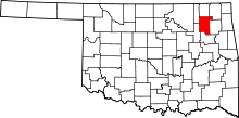 | |
| Towns | ||
| CDPs | ||
| Other unincorporated communities |
| |
| Footnotes | ‡This populated place also has portions in an adjacent county or counties | |