Onna, Okinawa
| Onna 恩納村 Unna | |
|---|---|
| Village | |
 Location of Onna in Okinawa Prefecture | |
 Onna Location in Japan | |
| Coordinates: 26°29′N 127°51′E / 26.483°N 127.850°ECoordinates: 26°29′N 127°51′E / 26.483°N 127.850°E | |
| Country | Japan |
| Region | Kyushu (Okinawa) |
| Prefecture | Okinawa Prefecture |
| District | Kunigami |
| Area | |
| • Total | 50.77 km2 (19.60 sq mi) |
| Population (2013) | |
| • Total | 10,443 |
| • Density | 210/km2 (530/sq mi) |
| Time zone | Japan Standard Time (UTC+9) |
| Website |
www |
Onna (恩納村 Onna-son, Okinawan: Unna) is a village located in Kunigami District, Okinawa Prefecture, Japan.[1]
As of 2013, the village had an estimated population of 10,443 and a population density of 210 persons per km². The total area is 50.77 square kilometres (19.60 sq mi). Unlike other areas of Japan, Onna has been in an sustained period of population growth in the post-war period. In 1965 the population of the village was 8,471, and by 2003 had grown to over 10,000 residents.[2]
Onna is the site of the Okinawa Institute of Science and Technology, a research institute turned graduate university.
History
Onna was first established as Unna Magiri (恩納間切) in 1673 by the Ryukyu Kingdom. Ryukyu was annexed by Japan in 1879. In 1908, the Japanese government dissolved Unna Magiri and replaced it with Onna Village.
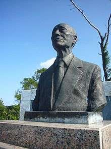
The village is the site of the tomb of the Republic of China statesman Fang Chih, founder and Chairman of the Sino-Ryukyuan Cultural and Economic Association.[3]
Geography

Onna is located in the central part of Okinawa Island, and occupies a long, narrow stretch of the western coast of the island. The village spans 27.4 kilometres (17.0 mi) from north to south but only 4.2 kilometres (2.6 mi) from east to west. The village is located in the rugged Sekiryo Mountains that run from the north to central Okinawa Island, with Mount Onna being the highest point in the village. Settlements in the village are located in the few flatter areas.[1][4]
The coastal areas of Onna was declared part of Okinawa Kaigan Quasi-National Park in 1972 after the reversion of Okinawa Prefecture to Japan. Onna is noted for its coastal scenery, notably Cape Manzamō and Cape Maeda.[1]
Neighboring Municipalities
Onna borders on six other municipalities in Okinawa prefecture.
Economy
Since World War II Onna has been a small-scale center of sugarcane production but tourists from mainland Japan, China, Taiwan, S. Korea, Australia and many other countries stay in one of the many seaside resorts that have been built just before, and after, the beginning of the new millennium. In recent years pineapples and mikan, or satsuma mandarin, have been grown in the rugged hill areas of the village. Like other municipalities on Okinawa Island, cut flowers and greenhouse vegetables intended for the Japanese homelands have become important agricultural products.[1]
Tourism also plays an increasingly important part of the Onna, Okinawa economy and has grown significantly in the last decade.[5] Resort hotels were built along the coastal areas in Onna after the reversion of Okinawa Prefecture to Japan in 1972, and tourism remains and important part of the economy of the village and the Onna prefecture.[1]

Transportation
Roads
Onna is crossed by Japan National Route 58, which connects the village of Kunigami in the north of Okinawa to the prefectural capital of Naha in the south. Okinawa Prefectural Route 6 intersects Route 58 at Nakadomari Village and passes through the village before intersecting with 58 again at the north end of Nakadomari. Route 73 runs east-west through the narrowest portion of Okinawa and connects Nakadomari Village on the East China Sea (west) coast to Ishikawa on the Pacific (east) coast. Prefectural Routes 86 and 104 connect the north of Onna with the town of Kin.[4]
References
- 1 2 3 4 5 "恩納(村)" [Onna]. Nihon Daihyakka Zensho (Nipponika) (in Japanese). Tokyo: Shogakukan. 2013. OCLC 153301537. Retrieved 2013-05-02.
- ↑ 人口推移 [Population Change] (in Japanese). Onna, Okinawa Prefecture, Japan: Village of Onna. 2013. Retrieved 2013-06-17.
- ↑ "琉球之友". http://ryukyushimpo.jp/ (in Japanese). Ryukyu Shimpo. 1 December 2008. Retrieved 11 November 2015.
恩納村の高台の木立に大きな墓苑がある。中央には東シナ海を遠く見つめる男性の胸像がありその背後の石碑には大きく琉球之友と記されている。在台湾の民間窓口である中琉文化経済協会初代理事長方治氏の墓苑である。方治氏は世界的に活躍するデザイナー「アナ・スイ」の実の祖父として知られており数年前には彼女自身が恩納村に墓参りに訪れ話題をよんだ。方治氏は台琉交流の旗頭として戦後ながきに渡り沖縄のために農業、産業、文化、人的交流、また台湾への多数の留学生の保証人としての受け入れにご尽力された。石碑には墓苑建立に携わり沖縄の戦後復興に力を注がれた偉大な方々の名前が刻まれている。琉球を熱愛し第二の故郷とした方治氏の墓苑そのものが、その当時の台湾と琉球の篤(あつ)き交流の形を今に伝える。 現在、方治氏の意志を受け継ぎ現任の理事長蔡雪泥女史(74)が台琉交流のために奔走されている。蔡女史は家政、服飾、美容等の分野で教鞭(きょうべん)をとられ成功を収めていたが44歳より児童教育事業への転身を決め、台湾で公文式教育の創始者となった。沖縄県第一号終身民間大使である蔡女史は台湾の教育、福祉におけるその豊富な経験を沖縄のために全力で注がれている。
line feed character in|quote=at position 338 (help); External link in|website=(help) - 1 2 3 恩納村概要 [Overview of Onna] (in Japanese). Onna, Okinawa Prefecture, Japan: Village of Onna. 2011. Retrieved 2013-06-17.
- ↑ http://english.ryukyushimpo.jp/2014/02/28/13256/
External links
 Media related to Onna, Okinawa at Wikimedia Commons
- Onna-son Prefecture on Google Maps
- Onna official website (Japanese)