Omolon (rural locality)
| Omolon (English) Омолон (Russian) | |
|---|---|
|
- Rural locality[1] - Selo[1] | |
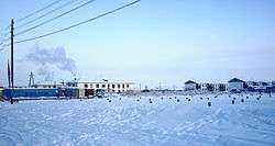 Winter view of Omolon. | |
.svg.png) Location of Chukotka Autonomous Okrug in Russia | |
 Omolon | |
|
| |
| Administrative status (as of June 2009) | |
| Country | Russia |
| Federal subject | Chukotka Autonomous Okrug[1] |
| Administrative district | Bilibinsky District[1] |
| Municipal status (as of October 2010) | |
| Municipal district | Bilibinsky Municipal District[2] |
| Rural settlement | Omolon Rural Settlement[2] |
| Administrative center of | Omolon Rural Settlement[2] |
| Statistics | |
| Area (rural settlement) (2010) | 2.7 km2 (1.0 sq mi)[3] |
| Population (2010 Census) | 873 inhabitants[4][5] |
| Population (January 2016 est.) | 791 inhabitants[6] |
| Density | 323/km2 (840/sq mi)[7] |
| Time zone | PETT (UTC+12:00)[8] |
| Founded | 1944[3] |
| Postal code(s)[9] | 689470 |
| Dialing code(s) | +7 42738[10] |
Omolon (Russian: Омолон) is a rural locality (a selo) in Bilibinsky District of Chukotka Autonomous Okrug, Russia.[1] It is situated in the far southwest of the district near the border with Magadan Oblast. Population: 873 (2010 Census);[4] Municipally, Omolon is subordinated to Bilibinsky Municipal District and is incorporated as Omolon Rural Settlement.[2]
History
Omolon was the headquarters for the sovkhoz (state farm) Omolon until 1992[11] Prior to 1992, the Sovkhoz had 15 separate herds of reindeer under its control.[11] From 1992 onwards, the Sovkhoz structure was dismantled bit by bit in line with the wider course of Russian privatisation.[11] Previously, the Sovkhoz had been in control of all of the major community services, such as power, education, health and other functions, which were now administered individually at rural settlement or district administrative level.[11] Four of the 15 brigades split from the former Sovkhoz and formed their own private enterprise and those remaining formed a limited liability company called TOO "Omolon"'.[11] This privatisation was not a success. Where previously the Sovkhoz had controlled the settlement's economy and its associated facilities, by 1998 there were nine separate entities involved in the same work and the number of reindeer held by the brigades had fallen from nearly 34,000 to just over 9,000.[11]
Geography
The village, previously called Oloy, Unyagan, and Shcherbakovo before the current name was settled upon in 1960,[12] is the most isolated populated place in Bilibinsky District. Omolon is situated on the banks of the Omolon River. The village is 670 kilometers (420 mi) from Bilibino and 780 kilometers (480 mi) from Anadyr.[3]
Economy
The main occupation of the inhabitants is reindeer herding.[12]
Demographics
The population as of the beginning of January 2012 was 855,[3] mainly Evens,[13] a reduction on the official 2010 census record of 855, of whom 453 were male and 420 female.[4][5] This represents a fall of around 200 from a 2006 estimate of 1,050, of which around 800 were indigenous peoples[12] As of January 2010, the ethnic make up of the village was as following:
| Indigenous People | Number in Village | Percentage of Population |
|---|---|---|
| Even |
488 |
57% |
| Chukchi |
178 |
21% |
| Yukagirs |
27 |
3% |
| Koryaks |
11 |
1% |
| Yupik |
3 |
<1% |
| Others |
148 |
17% |
| Total |
855 |
100% |
Source:[3]
Note: "Other" includes Russians and Ukrainians amongst others.
Based on a 2006 estimate, the population was 1050 of which around 800 are indigenous peoples.,[12] mainly Evens and Chukchi,[13] up from 936 people as recorded by an environmental impact report prepared in 2005 for the Kupol Gold Project.[14]
The head of the rural settlement is Viktoriya Valbertovna Sirova.[3]
Transport
Omolon is not connected by road to any other inhabited locality.[15] The only means of access to the village is along the Omolon River, or by air.
Air
An aerodrome "Shcherbakhovo" with ICAO code UHMN is mentioned by several sources.
Road
There is however a network of roads within the village including:[16]
- Улицa Авиаторов (Ulitsa Aviatorov, lit. Aviators' Street)
- Улицa Береговая (Ulitsa Beregovaya)
- Улицa Заречная (Ulitsa Zarechnaya)
- Улицa Клубная (Ulitsa Klubnaya, lit. Club Street)
- Улицa Лесная (Ulitsa Lechnaya, lit. Forest Street)
- Улицa Парковая (Ulitsa Parkovaya, lit. Park Street)
- Улицa Портовая (Ulitsa Portovaya)
- Улицa Профсоюзная (Ulitsa Profsoyuznaya, lit. Union Street)
- Улицa Советская (Ulitsa Sovetskaya, lit. Soviet Street)
- Улицa Сульженко (Ulitsa Sulzhenko)
- Улицa Черепова (Ulitsa Cherepova)
- Улицa Школьная (Ulitsa Shkolnaya, lit. School Street)
- Улицa Южная (Ulitsa Yuzhnaya, lit. South Street)
Climate
Omolon has a subarctic climate (Köppen Dfc/Dfd), with long, very cold winters, and short, cool summers. Average monthly temperatures range from −37.5 °C (−49.7 °F) in January to +14.8 °C (61.70 °F) in July. Mean monthly temperatures are below freezing from October through April and exceed +10 °C (50 °F) from June through August, with the intervening months of May and September constituting very short transitional seasons. The lowest temperature ever recorded in Omolon was −61.1 °C (−77.98 °F) in February 2002, but highest temperature was 34.0 °C (93.20 °F) in July 2010, yielding a temperature range of 95.1 °C. Temperature in summer months June, July and August, especially in July, often reach 30 °C (86.00 °F) and these are not uncommon occurrences. According to data available, the temperature has never been above freezing in February.
| Climate data for Omolon | |||||||||||||
|---|---|---|---|---|---|---|---|---|---|---|---|---|---|
| Month | Jan | Feb | Mar | Apr | May | Jun | Jul | Aug | Sep | Oct | Nov | Dec | Year |
| Record high °C (°F) | 0.8 (33.4) |
−0.6 (30.9) |
4.0 (39.2) |
8.0 (46.4) |
25.5 (77.9) |
31.8 (89.2) |
34.0 (93.2) |
31.2 (88.2) |
25.3 (77.5) |
15.0 (59) |
4.5 (40.1) |
3.7 (38.7) |
34.0 (93.2) |
| Average high °C (°F) | −33.4 (−28.1) |
−29.4 (−20.9) |
−17.8 (0) |
−5.8 (21.6) |
7.4 (45.3) |
18.3 (64.9) |
21.2 (70.2) |
16.5 (61.7) |
8.4 (47.1) |
−5.7 (21.7) |
−21.6 (−6.9) |
−31.8 (−25.2) |
−6.1 (21) |
| Daily mean °C (°F) | −37.5 (−35.5) |
−34.7 (−30.5) |
−25.3 (−13.5) |
−13.0 (8.6) |
2.4 (36.3) |
12.2 (54) |
14.8 (58.6) |
10.4 (50.7) |
3.2 (37.8) |
−10.0 (14) |
−25.7 (−14.3) |
−35.6 (−32.1) |
−11.6 (11.1) |
| Average low °C (°F) | −41.5 (−42.7) |
−39.5 (−39.1) |
−32.4 (−26.3) |
−21.1 (−6) |
−3.2 (26.2) |
5.6 (42.1) |
8.1 (46.6) |
4.6 (40.3) |
−1.5 (29.3) |
−14.2 (6.4) |
−29.9 (−21.8) |
−39.5 (−39.1) |
−17.0 (1.4) |
| Record low °C (°F) | −60.9 (−77.6) |
−61.1 (−78) |
−57.2 (−71) |
−48.4 (−55.1) |
−31.3 (−24.3) |
−5.1 (22.8) |
−3.5 (25.7) |
−9.3 (15.3) |
−21.8 (−7.2) |
−37.7 (−35.9) |
−54.1 (−65.4) |
−59.9 (−75.8) |
−61.1 (−78) |
| Average precipitation mm (inches) | 10 (0.39) |
9 (0.35) |
9 (0.35) |
7 (0.28) |
13 (0.51) |
29 (1.14) |
44 (1.73) |
50 (1.97) |
26 (1.02) |
18 (0.71) |
18 (0.71) |
13 (0.51) |
246 (9.69) |
| Average rainy days | 0 | 0 | 0 | 0.1 | 4 | 10 | 12 | 13 | 8 | 0.3 | 0 | 0 | 47.4 |
| Average snowy days | 15 | 14 | 13 | 9 | 4 | 0.4 | 0 | 0.1 | 4 | 18 | 16 | 17 | 110.5 |
| Average relative humidity (%) | 74 | 73 | 70 | 67 | 61 | 61 | 67 | 74 | 76 | 79 | 78 | 75 | 71 |
| Source: Pogoda.ru.net[17] | |||||||||||||
See also
References
Notes
- 1 2 3 4 5 Law #33-OZ, Article 13.2
- 1 2 3 4 Law #43-OZ, Article 2
- 1 2 3 4 5 6 Official website of Bilibinsky Municipal District. Urban and Rural Settlements. Retrieved August 28, 2012. (Russian)
- 1 2 3 Russian Federal State Statistics Service (2011). "Всероссийская перепись населения 2010 года. Том 1" [2010 All-Russian Population Census, vol. 1]. Всероссийская перепись населения 2010 года (2010 All-Russia Population Census) (in Russian). Federal State Statistics Service. Retrieved June 29, 2012.
- 1 2 The results of the 2010 Census are given for Omolon Rural Settlement, a municipal formation of Bilibinsky Municipal District. According to Law #148-OZ, Omolon is the only inhabited locality on the territory of Omolon Rural Settlement.
- ↑ Chukotka Autonomous Okrug Territorial Branch of the Federal State Statistics Service. Численность постоянного населения Чукотского автономного округа по муниципальным образованиям на 1 января 2016 года (Russian)
- ↑ The value of density was calculated automatically by dividing the 2010 Census population by the area specified in the infobox. Please note that this value may not be accurate as the area specified in the infobox does not necessarily correspond to the area of the entity proper or is reported for the same year as the population.
- ↑ Правительство Российской Федерации. Федеральный закон №107-ФЗ от 3 июня 2011 г. «Об исчислении времени», в ред. Федерального закона №271-ФЗ от 03 июля 2016 г. «О внесении изменений в Федеральный закон "Об исчислении времени"». Вступил в силу по истечении шестидесяти дней после дня официального опубликования (6 августа 2011 г.). Опубликован: "Российская газета", №120, 6 июня 2011 г. (Government of the Russian Federation. Federal Law #107-FZ of June 31, 2011 On Calculating Time, as amended by the Federal Law #271-FZ of July 03, 2016 On Amending Federal Law "On Calculating Time". Effective as of after sixty days following the day of the official publication.).
- ↑ Почта России. Информационно-вычислительный центр ОАСУ РПО. (Russian Post). Поиск объектов почтовой связи (Postal Objects Search) (Russian)
- ↑ Ministry of Justice of the Russian Federation Bilibinsky Municipal District
- 1 2 3 4 5 6 The Obshchina in Chukotka - Land Property and Local Autonomy, Gray P.A. (2001), Max Planck Institute for Social Anthropology. p.11
- 1 2 3 4 Fute, p. 104
- 1 2 Norwegian Polar Institute. Indigenous Peoples of the north of the Russian Federation, Map 3.6, Chukotskiy Avtonomyy Okrug
- ↑ Environmental Impact Assessment, Kupol Gold Project, Far East Russia June 2005, prepared by Bema Gold Corporation
- ↑ Map Q-57-58 at Vlasenko.net
- ↑ Omolon - Bilibinsky District at Pochtovik Mail Delivery Company
- ↑ "Pogoda.ru.net" (in Russian). Retrieved May 13, 2012.
Sources
- Bema Gold Corporation, Environmental Impact Assessment, Kupol Gold Project, Far East Russia June 2005.
- W. K. Dallmann. Indigenous Peoples of the north of the Russian Federation, Map 3.6, Chukotskiy Avtonomyy Okrug. 1997.
- Дума Чукотского автономного округа. Закон №33-ОЗ от 30 июня 1998 г. «Об административно-территориальном устройстве Чукотского автономного округа», в ред. Закона №55-ОЗ от 9 июня 2012 г. «О внесении изменений в Закон Чукотского автономного округа "Об административно-территориальном устройстве Чукотского автономного округа"». Вступил в силу по истечении десяти дней со дня его официального опубликования. Опубликован: "Ведомости", №7 (28), 14 мая 1999 г. (Duma of Chukotka Autonomous Okrug. Law #33-OZ of June 30, 1998 On the Administrative-Territorial Structure of Chukotka Autonomous Okrug, as amended by the Law #55-OZ of June 9, 2012 On Amending the Law of Chukotka Autonomous Okrug "On the Administrative-Territorial Structure of Chukotka Autonomous Okrug". Effective as of after ten days from the day of the official publication.).
- Дума Чукотского автономного округа. Закон №43-ОЗ от 29 ноября 2004 г. «О статусе, границах и административных центрах муниципальных образований на территории Билибинского района Чукотского автономного округа», в ред. Закона №88-ОЗ от 20 октября 2010 г «О преобразовании путём объединения поселений на территории Билибинского муниципального района и внесении изменений в Закон Чукотского автономного округа "О статусе, границах и административных центрах муниципальных образований на территории Билибинского района Чукотского автономного округа"». Вступил в силу через десять дней со дня официального опубликования. Опубликован: "Ведомости", №31/1 (178/1), 10 декабря 2004 г. (Duma of Chukotka Autonomous Okrug. Law #43-OZ of November 29, 2004 On the Status, Borders, and Administrative Centers of the Municipal Formations on the Territory of Bilibinsky District of Chukotka Autonomous Okrug, as amended by the Law #88-OZ of October 20, 2010 On the Transformation (Merger) of the Settlements on the Territory of Bilibinsky Municipal District and Amending the Law of Chukotka Autonomous Okrug "On the Status, Borders, and Administrative Centers of the Municipal Formations on the Territory of Bilibinsky District of Chukotka Autonomous Okrug". Effective as of the day ten days after the official publication date.).
- M Strogoff, P-C Brochet, and D. Auzias Petit Futé: Chukotka (2006). "Avant-Garde" Publishing House.
External links
Administrative center: Anadyr | ||
| Cities and towns | ||
| Urban-type settlements | ||
| Administrative districts (raions) | ||