Omarama
| Omarama | |
|---|---|
| Township | |
 | |
| Motto: The Place of Light | |
 Omarama | |
| Coordinates: 44°29′0″S 169°58′0″E / 44.48333°S 169.96667°ECoordinates: 44°29′0″S 169°58′0″E / 44.48333°S 169.96667°E | |
| Country | New Zealand |
| Region | Canterbury |
| Territorial authority | Waitaki District |
| Population (2006)[1] | |
| • Total | 231 |
| Time zone | NZST (UTC+12) |
| • Summer (DST) | NZDT (UTC+13) |
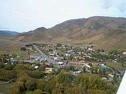
Omarama is a small township (population 231 at 2006 census) at the junction of State Highways 8 and 83, near the southern end of the Mackenzie Basin, in the South Island of New Zealand. Omarama is in the Waitaki District, in the historic Province of Otago. The Ahuriri River is a short distance to the north of the township.
Omarama is primarily a rural service centre, providing local farmers and other residents with necessities and facilities such as grocery shopping, fuel and mechanical services, as well as a post shop.
In more recent years these and similar services have expanded moderately, due to the increase in new residents and visitors, including anglers, artists, astronomers, sailplane enthusiasts, skiers and general tourists.
A significant proportion of permanent village residents are employees of (or contractors to) Meridian Energy Limited, a state-owned enterprise which is responsible for much of New Zealand's hydroelectricity generation.
Omarama is Māori for "Place of Light", a reference to its extraordinarily pure and clear sky.
Agriculture

Although traditionally sheep country, Omarama area farms, along with those within the rest of the Mackenzie Basin, have rapidly converted to predominantly dairy farming, due to falling sheep meat and wool prices, and the recent boom in dairy product earnings.
This conversion has necessitated major changes to the local environment, with iconic tussock lands being ploughed and replaced by pasture, which has been facilitated by new irrigation schemes. Large centre pivot irrigators and private canal networks now dominate much of the landscape.
Recently however, diminishing returns on dairy-based agriculture have led to farmers investigating alternative methods and practices, some now experimenting with biofuel crops.
Angling
There are many rivers and lakes in and near Omarama suitable for recreational fishing. The nearby Ahuriri River is a noted fly-fishing river and adjacent Lake Benmore and Lake Ohau are popular with boaters, as well as fly casters and other anglers.
Commonly encountered local fish species include salmon, and brown and rainbow trout.
Astronomy
Omarama is home of the annual mid winter star party. Local street lighting and other light sources are dimmed or switched off for the duration of the event.
Benmore Peak Observatory is located approximately 13 km north of Omarama, atop the nearby Benmore Range
Gliding
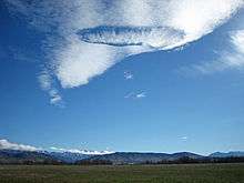
Due to the strong gliding conditions and spectacular scenery in the Omarama area, as well as the entire Mackenzie Basin, it is known as a world-class gliding location, gaining fame among sailplane pilots around the world after hosting the 1995 World Gliding Championships.
Pilots come to Omarama to experience strong lee wave conditions, ridge soaring and thermal flying. It is common for Omarama-based gliders to soar hundreds of kilometers along the Southern Alps each day. In ideal conditions, it is possible for gliders to reach distances in excess of 1000 km. Several national and world gliding records have been achieved from Omarama, and the prevailing conditions have attracted record seekers such as Steve Fossett.
The Omarama Gliding Club and several commercial gliding organizations are based in Omarama.
Snow sports
There are three skifields within the MacKenzie Basin; Ohau, Round Hill, and Mount Dobson.
Other attractions
Omarama is a popular holiday destination amongst those living in surrounding districts and provinces, many owning family holiday residences within the village. Tramping is also popular with locals and visitors alike, due to the spectacular and often rugged landscape. Due to the spectacular scenery, numerous artists regularly visit the Omarama area, and several are now permanent residents, exhibiting their Omarama and Mackenzie landscapes and other work in local galleries and further afield.
Omarama is on the route of the Alps to Ocean Cycle Trail, after the trail was constructed following approval in 2010.
In popular culture
In his novel The Zombie Survival Guide, Max Brooks of World War Z fame makes reference to Omarama as site of a historical zombie attack.
References
- ↑ "QuickStats About Omarama". 2006 Census. Statistics New Zealand. Retrieved 6 December 2011.
External links
| Wikivoyage has a travel guide for Omarama. |
| Wikimedia Commons has media related to Omarama. |