Olympia Heights, Florida
| Olympia Heights, Florida | |
|---|---|
| CDP | |
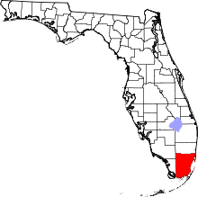
 Location in Miami-Dade County and the state of Florida | |
 U.S. Census Bureau map showing CDP boundaries | |
| Coordinates: 25°43′35″N 80°20′42″W / 25.72639°N 80.34500°WCoordinates: 25°43′35″N 80°20′42″W / 25.72639°N 80.34500°W | |
| Country |
|
| State |
|
| County | Miami-Dade |
| Area | |
| • Total | 3 sq mi (7.9 km2) |
| • Land | 2.7 sq mi (7.1 km2) |
| • Water | 0.3 sq mi (0.8 km2) |
| Elevation | 7 ft (2 m) |
| Population (2000) | |
| • Total | 13,452 |
| • Density | 4,484/sq mi (1,702.8/km2) |
| Time zone | Eastern (EST) (UTC-5) |
| • Summer (DST) | EDT (UTC-4) |
| Area code(s) | 305 |
| FIPS code | 12-51475[1] |
| GNIS feature ID | 0288154[2] |
Olympia Heights is a census-designated place (CDP) in Miami-Dade County, Florida, United States. The population was 13,488 at the 2010 census.
Geography
Olympia Heights is located at 25°43′35″N 80°20′42″W / 25.72639°N 80.34500°W (25.726379, -80.345073).[3]
According to the United States Census Bureau, the CDP has a total area of 3.0 square miles (7.8 km2), of which, 2.7 square miles (7.0 km2) of it is land and 0.3 square miles (0.78 km2) of it (9.63%) is water.
Demographics
| Historical population | |||
|---|---|---|---|
| Census | Pop. | %± | |
| 1980 | 33,112 | — | |
| 1990 | 37,792 | 14.1% | |
| 2000 | 13,452 | −64.4% | |
| 2010 | 13,488 | 0.3% | |
| source:[4][5] | |||
As of the census[1] of 2000, there were 13,452 people, 4,157 households, and 3,487 families residing in the CDP. The population density was 4,941.5 people per square mile (1,909.5/km²). There were 4,231 housing units at an average density of 1,554.2/sq mi (600.6/km²). The racial makeup of the CDP was 93.50% White (of which 22.3% were Non-Hispanic White,)[6] 0.83% African American, 0.10% Native American, 0.91% Asian, 2.46% from other races, and 2.19% from two or more races. Hispanic or Latino of any race were 76.33% of the population.
There were 4,157 households out of which 30.2% had children under the age of 18 living with them, 65.2% were married couples living together, 13.6% had a female householder with no husband present, and 16.1% were non-families. 12.4% of all households were made up of individuals and 6.8% had someone living alone who was 65 years of age or older. The average household size was 3.22 and the average family size was 3.41.
In the CDP the population was spread out with 20.0% under the age of 18, 7.7% from 18 to 24, 26.7% from 25 to 44, 26.1% from 45 to 64, and 19.6% who were 65 years of age or older. The median age was 42 years. For every 100 females there were 91.8 males. For every 100 females age 18 and over, there were 88.9 males.
The median income for a household in the CDP was $50,720, and the median income for a family was $54,533. Males had a median income of $34,382 versus $23,406 for females. The per capita income for the CDP was $18,198. About 5.4% of families and 6.9% of the population were below the poverty line, including 5.8% of those under age 18 and 10.9% of those age 65 or over.
As of 2000, speakers of Spanish as a first language accounted for 80.44% of residents, while English as a mother tongue made up 19.55% of the population.[7]
As of 2000, Olympia Heights had the sixth highest percentage of Cuban residents in the US, with 57.65% of the populace.[8] It also had the seventy-seventh highest percentage of Colombian residents in the US, at 1.99% of the population,[9] and the twenty-fifth highest percentage of Nicaraguan residents in the US, at 1.80% of its population.[10]
Education
Miami-Dade County Public Schools serves Olympia Heights.
Blue Lakes Elementary School is in Olympia Heights.[11] Olympia Heights Elementary School is located in University Park CDP, adjacent to Olympia Heights.[11] [12]
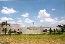
Southwest Miami High School is located in Olympia Heights.[11][13]
Private schools in Olympia Heights include Gulliver Pinecrest Preparatory School Miller Drive Campus, Florida Christian School, and King's Christian School.[11][14] Pinecrest Preparatory opened in 1996.[15]
References
- 1 2 "American FactFinder". United States Census Bureau. Retrieved 2008-01-31.
- ↑ "US Board on Geographic Names". United States Geological Survey. 2007-10-25. Retrieved 2008-01-31.
- ↑ "US Gazetteer files: 2010, 2000, and 1990". United States Census Bureau. 2011-02-12. Retrieved 2011-04-23.
- ↑ "CENSUS OF POPULATION AND HOUSING (1790-2000)". U.S. Census Bureau. Retrieved 2010-07-17.
- ↑ Part of 1990 census territory lost to University Park
- ↑ "Demographics of Olympia Heights, FL". MuniNetGuide.com. Retrieved 2007-11-07.
- ↑ "MLA Data Center Results of Olympia Heights, FL". Modern Language Association. Retrieved 2007-11-07.
- ↑ "Ancestry Map of Cuban Communities". Epodunk.com. Retrieved 2007-11-07.
- ↑ "Ancestry Map of Colombian Communities". Epodunk.com. Retrieved 2007-11-07.
- ↑ "Ancestry Map of Nicaraguan Communities". Epodunk.com. Retrieved 2007-11-07.
- 1 2 3 4 "2010 CENSUS - CENSUS BLOCK MAP: Olympia Heights CDP, FL" (Archive). U.S. Census Bureau. Retrieved on January 3, 2015.
- ↑ "2010 CENSUS - CENSUS BLOCK MAP: University Park CDP, FL" (Archive). U.S. Census Bureau. Retrieved on January 3, 2015.
- ↑ Home page. Southwest Miami High School. Retrieved on January 3, 2016. "8855 SW 50th Terrace Miami, FL 33165"
- ↑ Home page. Gulliver Schools. Retrieved on January 3, 2016. "8000 SW 56 Street Miami, Florida 33155"
- ↑ "Gulliver Pinecrest Prep Campus." Gulliver Schools. Retrieved on September 28, 2009.