Olmsted Park
Olmsted Park is a linear park in Boston and Brookline, Massachusetts, and a part of Boston's Emerald Necklace of connected parks and parkways. Originally named Leverett Park, in 1900 it was renamed to honor its designer, Frederick Law Olmsted.[1]
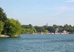
Olmsted Park can be roughly divided into two parts. In the south, bordering Jamaica Pond, it includes athletic fields and three ponds: from the south, a small kettle pond called Ward's Pond, the tiny Willow Pond, and the much larger Leverett's Pond. The northern section of the park, above Route 9, is a narrow corridor through which the Muddy River flows on its way to the Charles River. The northern edge of Olmsted Park connects to the Back Bay Fens and the western edge of the Mission Hill neighborhood.
Olmsted, who had made a reputation designing New York City's Central Park, suggested in 1880 that the swampy and brackish Muddy River be included in Boston's park plan. Beginning in 1890, the river was dredged into a winding stream, a large swamp converted into Leverett's Pond, and Ward's Pond was connected with a small outflowing stream.
Following completion of the Emerald Necklace Parks Master Plan in 1989 (updated in 2001 [2]), a number of improvements have been made in Olmsted Park. Riverdale Parkway, originally designed as a carriage road, was transformed into a bicycle and pedestrian path in 1997. The Allerton Overlook at the foot of Allerton Street in Brookline was recreated, footbridges re-pointed, and a boardwalk placed at the south end of Wards Pond.
In 2006, Brookline restored Olmsted's "Babbling Brook" (a section of the Muddy River in the park),[3] resetting stones, clearing out invasive knotweed, defining the streambed, and replanting trees and shrubs to inhibit future invasives growth.
The close proximity of Longwood Medical and Academic Area and easy access to the MBTA make the park a popular walking and bicycling route.
Muddy River Restoration Project
Olmsted park has long been subject to flooding from the Muddy River. The Muddy River Restoration Project [4] will dredge contaminated sediments and implement other major structural improvements, unburying the river and improving its integrity, appearance, and flood control capabilities.[5] [6]
Friends of Leverett Pond
"Friends of Leverett Pond" was the second of the Town of Brookline's Park Friends Groups created as a park advocacy organization in the 1970s. Formed in 1978 as a sub-committee of the High Street Hill Association, it has worked to improve the condition of Olmsted Park and to increase awareness of issues of park stewardship." [7]
Gallery
|


External links
- Friends of Leverett Pond
- Friends of Olmsted Park an offshoot of Friends of Jamaica Pond
- Emerald Necklace Conservancy
References
- ↑ Olmsted Park Archived August 30, 2007, at the Wayback Machine.
- ↑ Archived May 11, 2008, at the Wayback Machine.
- ↑ "HSHA - Babbling Brook Restoration". Highstreethill.org. 2006-03-11. Retrieved 2013-09-10.
- ↑ "Muddy River Project". Pinebank.org. 2007-12-20. Retrieved 2013-09-10.
- ↑ Archived October 2, 2008, at the Wayback Machine.
- ↑ http://web.archive.org/web/20091022070325/http://geocities.com/muddybemuddy/summary.html
- ↑ "HSHA - Friends of Leverett Pond". Highstreethill.org. 2003-06-15. Retrieved 2013-09-10.
 | ||
Coordinates: 42°19′33″N 71°06′54″W / 42.3259°N 71.1149°W