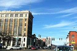
Olean, New York
| Olean, New York | |
|---|---|
| City | |
 | |
 Olean Location within the state of New York | |
| Coordinates: 42°4′57″N 78°25′51″W / 42.08250°N 78.43083°WCoordinates: 42°4′57″N 78°25′51″W / 42.08250°N 78.43083°W | |
| Country | United States |
| State | New York |
| County | Cattaraugus |
| Government | |
| • Type | Mayor-Council |
| • Mayor |
William Aiello (R) |
| • Common Council |
Members' List
|
| Area | |
| • Total | 6.2 sq mi (16.0 km2) |
| • Land | 5.9 sq mi (15.3 km2) |
| • Water | 0.3 sq mi (0.7 km2) |
| Population (2010) | |
| • Total | 14,452 |
| • Density | 2,446/sq mi (944.5/km2) |
| Time zone | EST (UTC−5) |
| • Summer (DST) | EDT (UTC−4) |
| Area code(s) | 716, 585 |
| FIPS code | 36-54716 |
| Website |
www |
Olean (/ˈoʊliːæn/ ᴏʜ-lee-an) is a city in Cattaraugus County, New York, United States. Olean is the largest city in Cattaraugus County and serves as its financial, business, transportation and entertainment center. It is one of the principal cities of the Southern Tier region of New York.
The city is surrounded by the town of Olean and is located in the southeastern part of the county. The population was 14,452 at the 2010 census.[1]
Geography
Olean is located in southeastern Cattaraugus County at 42°4′57″N 78°25′51″W / 42.08250°N 78.43083°W (42.08264, -78.430965).[2]
According to the United States Census Bureau, the city has a total area of 6.2 square miles (16.0 km2), of which 5.9 square miles (15.3 km2) is land and 0.27 square miles (0.7 km2), or 4.19%, is water.[1]
The city is located where Olean Creek flows into the Allegheny River and by the Southern Tier Expressway (Interstate 86 and New York State Route 17). New York State Route 417 passes east-west through the city and intersects New York State Route 16, a north-south highway.
History
The first European in the area was possibly Joseph de La Roche Daillon, a missionary and explorer from Canada. La Roche reported on the presence of oil near Cuba, the first petroleum sighting in North America. At that time the area was a part of the territory of the Wenrohronon or Wenro Indians, an Iroquois speaking people. In 1643, the Wenro tribes became the first victims of a series of brutal conflicts known as the Second Beaver War.
The area was first settled by Europeans around 1765, called by the Indian name Ischua. Officially, this was illegal, as the British had declared the land in the Allegheny River watershed to be part of the Indian Reserve after conquering the territory in the French and Indian War two years prior. The surface is a hilly upland, separated into two distinct parts by the valley of the Allegheny. The highest points are 500 to 600 feet (150 to 180 m) above the valley. During the American Revolutionary War, the 1779 Sullivan Expedition established the first road to what would become Olean, blazing a trail to what is now Kittanning, Pennsylvania along the path of what is now New York State Route 16.
Originally the entire territory of the county of Cattaraugus was called the Town of Olean, formed March 11, 1808. As population allowed, the county was split in half and the top half was called "Hebe", and was taken off in 1812, a part of Perrysburgh in 1814, then Great Valley in 1818. Hinsdale formed in 1820, and Portville in 1837, leaving the current boundary of Olean that lies upon the south line of the county, near the southeast corner. The area remained sparsely populated until 1804, when Major Adam Hoops acquired the land and gave it its modern name. Hoops was a surveyor and Revolutionary War veteran, and was politically connected with Robert Morris, the financier of the Revolution. Along with Morris, Hoops became involved with the Holland Land Company, which was settling western New York.
This was a time of great western expansion into places like Ohio and Indiana. Since neither canals nor railroads had become widespread by this point, the main means of travel were either by cart or by small-boat travel. The Allegheny River was a major transportation route. Hoops believed that a great city could be created at the confluence of the Allegany and one of its tributaries, and went looking for the right spot. In 1804, he found one where Olean Creek meets the river, and received title to 20,000 acres (81 km2) from the Holland Land Company in 1804. Hoops' brother Robert came to the site and built the first permanent structure near today's Forness Park, calling the area Hamilton in honor of Alexander Hamilton.
In a letter to Joseph Ellicott in 1804, Hoops discusses the name Olean from the local Oil Springs and the Latin word oleum:
Canandaigua, N.Y., April 15, 1804 "To Joseph ELLICOTT, Esq., Batavia, New York. Dear Sir,―It was proposed to me at New York to drop the Indian name of Ischue or Ischua (it is also spelt other ways). Confusion might arise from the various spellings, of which to obviate all risk I have concluded so to do as proposed. The neighborhood of the oil spring suggests a name different in sound, though perhaps not different in meaning, which I wish to adopt,―it is "Olean." You will do me a favor by assisting me to establish this name. It may easily be done now by your concurrence. The purpose will be most effectually answered by employing the term, when occasion requires, without saying anything of an intended change of name. To begin, you will greatly oblige me by addressing the first letter you may have occasion to write to me, after I receive the survey, to the Mouth of Olean. The bearer being properly instructed, there will be thereafter no difficulty. Your co-operation in the matter (the effect of which, though not important in itself, may be so on account of precision) will oblige. Your servant, A. HOOPS
The Post Office recognized the new town as "Olean Point". The site was surveyed by 1808, and a map from that year shows a basic street pattern that still survives, along with most of the modern street names. In 1823, the city is called Olean, without the "Point", on county maps.
In 1854 Olean was formally incorporated by the New York State Legislature, and the trustees elected at the first subsequent town meeting were Dr. Lambert Thithney, C.B.B. Barse, Charles Thing, and John K. Comstock. Enos C. Brooks, descendant of Judge James Brooks and of Cornelius Brooks (one of the earliest settlers of Olean (1808)), was appointed Clerk of Olean.[3]
Timber and railroads
Adam Hoops's dream of creating a major transportation hub on the Allegheny River — on the scale of a Buffalo or a Pittsburgh — was never realized, and he himself died in poverty. Nonetheless, Olean prospered and was soon the central town of the region. Olean grew quickly as a transportation hub for migrants taking the Allegheny River into Ohio. For much of this era, Olean was larger and better known than its northern competitor, Buffalo. This period ended with the creation of the great canals, especially the Erie Canal in 1825. The Allegheny River was usually too shallow for the larger steamboats to navigate except in the spring, and only two steamboats—the Allegheny in 1830 and the New Castle of 1837—reached the city.[4] A Genesee Valley Canal was extended to Olean and the Allegheny River in 1862, but the Allegheny's shallowness and the rise of the railroads rendered it obsolete before it even opened.
Timber was a major industry in New York and Pennsylvania between 1830 and 1850, and Olean was the chief timber town in the region during those times. After river travel declined, Olean became the regional railroad hub. The town was the crossroads of several railroads, a situation which endures into today with the WNYP.
Olean was the home of several corporations. During the late 19th century, Olean had a few mills, a bicycle company, a manufacturer of mechanical pumps, and a glass works, among other factories. St. Bonaventure University was founded just outside town in 1858. Olean was incorporated as a village in 1854, and as a city in 1893. Olean was rivals with the comparably populated, but much newer, city of Salamanca (city), New York at the turn of the 20th century, but the decline of the timber industry in southwestern Cattaraugus County and complications with Salamanca being situated on borrowed Seneca Nation land allowed Olean to continue growing while Salamanca declined.
Oil and rum-running
Oil was first discovered in the region by a French explorer in 1632, but it was rediscovered for commercial use during the Pennsylvania oil rush. Oil became the city's claim to fame for fifty years.
Olean was the railroad and pipeline hub for the surrounding oil region. The operations HQ of Standard Oil's New York affiliate, Socony, was based in the city. Oil produced on both sides of the state line (e.g. in Bradford, Pennsylvania) would be transported to Olean for rail travel. For a short time, Olean was the world's largest oil depot, complete with a "tank city" on the edge of town. A pipeline was also built linking the city to Standard Oil refineries in Bayonne, New Jersey. The oil industry maintained a presence in the city until 1954, the same year in which Olean's population peaked.
Oil also produced Olean's highest-ranking politician. Oil executive Frank W. Higgins was governor of New York in 1905-1907. Higgins' family owned grocery stores in the area, and Higgins also ran this business before his political career. To this day, Olean is one of the few smaller cities in New York State to be home to a governor.
Olean garnered notoriety as a major stop on bootlegging routes during Prohibition in 1920s. Dempsey, the Chief of Police, did not condone these thugs or their illegal activities. He did not aggressively pursue arrests, however, unless he had evidence the violator was responsible for a crime committed in his jurisdiction. As long as you kept your nose clean in the Olean City limits, it was a "safe haven". Local stories relating to this period are numerous. Some are documented and some are legends. Olean, located on a back road route between Chicago and New York City, was often frequented by famous mobsters of the era. Al Capone of Chicago, probably the most famous gang leader of the time, visited Olean in pursuance of his illegal endeavors. Olean was nicknamed "Little Chicago" in the press, due to its connection with mobsters and bootleggers, and Capone was a frequent visitor.[5]
Today
Olean is the largest city in Cattaraugus County. The city's population peaked at an estimated 25,000 during the mid-1950s. The current population of the city is roughly around 15,000.
Demographics
| Historical population | |||
|---|---|---|---|
| Census | Pop. | %± | |
| 1870 | 1,327 | — | |
| 1880 | 3,036 | 128.8% | |
| 1890 | 7,358 | 142.4% | |
| 1900 | 9,462 | 28.6% | |
| 1910 | 14,743 | 55.8% | |
| 1920 | 20,506 | 39.1% | |
| 1930 | 21,790 | 6.3% | |
| 1940 | 21,506 | −1.3% | |
| 1950 | 22,884 | 6.4% | |
| 1960 | 21,868 | −4.4% | |
| 1970 | 19,169 | −12.3% | |
| 1980 | 18,207 | −5.0% | |
| 1990 | 16,946 | −6.9% | |
| 2000 | 15,347 | −9.4% | |
| 2010 | 14,452 | −5.8% | |
| Est. 2015 | 13,870 | [6] | −4.0% |
As of the census[8] of 2000, there were 15,347 people, 6,446 households, and 3,803 families residing in the city. The population density was 2,588.0 people per square mile (999.2/km²). There were 7,121 housing units at an average density of 1,200.8 per square mile (463.6/km²). The racial makeup of the city was 93.31% White, 3.47% Black or African American, 0.43% Native American, 0.89% Asian, 0.03% Pacific Islander, 0.43% from other races, and 1.45% from two or more races. Hispanic or Latino of any race were 1.24% of the population.
There were 6,446 households out of which 29.1% had children under the age of 18 living with them, 42.0% were married couples living together, 13.2% had a female householder with no husband present, and 41.0% were non-families. 35.3% of all households were made up of individuals and 14.1% had someone living alone who was 65 years of age or older. The average household size was 2.29 and the average family size was 2.97.
In the city the population was spread out with 24.6% under the age of 18, 8.0% from 18 to 24, 27.2% from 25 to 44, 22.3% from 45 to 64, and 17.9% who were 65 years of age or older. The median age was 38 years. For every 100 females there were 88.1 males. For every 100 females age 18 and over, there were 84.3 males.
The median income for a household in the city was $30,400, and the median income for a family was $38,355. Males had a median income of $32,341 versus $22,469 for females. The per capita income for the city was $17,169. About 13.9% of families and 15.9% of the population were below the poverty line, including 20.5% of those under age 18 and 10.2% of those age 65 or over.
Economy
•Supreme Auto Parts and Service Inc. since 1980 automotive salvage parts, sales, and services.
- Cutco Cutlery Corp. is headquartered in Olean and manufactures all of its knives in the city.
- Dresser-Rand Group's North American headquarters was in Olean.
- Colonial Radio Group, which owns radio stations in the region and previously owned stations in the Carolinas, has been headquartered in Olean since 2009.
- Olean General Hospital, is part of Upper Allegheny Health System (UAHS), which includes Bradford Regional Medical Center (BRMC) in Bradford, PA. UAHS provides care to a service area with more than 160,000 individuals in Southwestern New York and Northwestern Pennsylvania.
- Olean Wholesale Grocery Cooperative, a regional grocery wholesaler, is located just east of the city.
Culture
- The city hosted the Miss New York pageant during the 1960s and '70s and held a parade with the reigning 1976 Miss America, Tawny Godin, who was crowned Miss New York in Olean.
- Part of the movie Unstoppable was filmed near the Olean Middle School.
Education
Olean High School is the city's public high school. It was the site of the Olean High School shooting in 1974.
Archbishop Walsh High School is Olean's Roman Catholic high school.
A branch of Jamestown Community College is within the city. St. Bonaventure University is a few miles to the west in the town of Allegany.
Sports
Olean is the home of the Southern Tier Diesel adult amateur football team.[9]
Bradner Stadium, originally built in the 1920s, is a multi-purpose stadium which was once the home to the minor-league baseball teams the Olean Oilers, who played in the short-season Pony League, and the Olean Yankees, an earlier team. In the summer, the stadium hosts the collegiate team that has revived the Olean Oilers,[10] and in the fall is the home for the Olean High School football team. A team representing Olean also plays in the local Town Team Baseball circuit.
Historic sites
The following are listed on the National Register of Historic Places: Beardsley-Oliver House, Conklin Mountain House, Oak Hill Park Historic District, Olean Armory, Olean Public Library, Olean School No. 10, St. Stephen's Episcopal Church Complex, Temple B'Nai Israel, Union and State Streets Historic District, and the United States Post Office.[11][12][13]
Notable people
Sports
- Claude Allen, Olympic athlete
- George Capwell, soccer manager
- Eddie Donovan, New York Knicks head coach (1961–1965), head coach, St. Bonaventure University, 1954–1961
- Bob Lanier, Basketball Hall of Fame player, St. Bonaventure University player (1967-1970), Detroit Pistons player 1970-1980, Milwaukee Bucks 1980-1984
- John McGraw, Baseball Hall of Fame player and manager
- John Wojcik, former MLB player
- Louis Zamperini, World War II prisoner of war survivor, inspirational speaker, and former American competitive runner
Media
- Peter Tomarken, game show host
The arts
- Sorrell Booke, actor
- Beverly Bower, opera singer
- Bill Easley, saxophonist
- JG Faherty, science fiction author
- Jeff Fahey, actor
- Donald Innis, architect who invented the floating airport
- Bobby Johnston, film composer, musician
- Robert Lax, poet
- Betty MacDonald, musician
- Grace Marra, musician
- Thomas Merton, religious writer
- Meg Saligman, muralist
- Tom Stephan (aka Superchumbo), remix artist
- Clifford Ulp, art professor
- Jon Serl, folk artist
Politics
- Augustus Barrows, Wisconsin lumberman and legislator
- Chauncey J. Fox, New York state senator
- Edward M. Gabriel, US ambassador to Morocco
- James F. Hastings, Republican U.S. congressman, 1969–1976
- Frank W. Higgins, governor of New York
- Frederick S. Martin, early Republican congressman
- Timothy H. Porter, congressman
- James C. Willson, 12th mayor of Flint, Michigan
- Catharine Young, New York state senator
Other notables
- Pandora Boxx, drag queen
- Arthur Harkins, futurist, professor
- George G. Lundberg, pilot
See also
- Radio stations in the Olean market
- National Register of Historic Places listings in Cattaraugus County, New York
References
- 1 2 "Geographic Identifiers: 2010 Demographic Profile Data (G001): Olean city, New York". U.S. Census Bureau, American Factfinder. Retrieved October 23, 2014.
- ↑ "US Gazetteer files: 2010, 2000, and 1990". United States Census Bureau. 2011-02-12. Retrieved 2011-04-23.
- ↑ HISTORY OF CATTARAUGUS COUNTY, NEW YORK, Town of Olean, L.H. Everts, 1879, Edited by Franklin Ellis Transcribed from pages 153-185 http://www.rootsweb.ancestry.com/~nycattar/1879history/olean.html
- ↑ State and Union: River-traffic dreams never realized at Olean Point. Olean Times Herald (May 22, 2016). Retrieved May 22, 2016.
- ↑ "Web Page". City of Olean. 2012-12-12.
- ↑ "Annual Estimates of the Resident Population for Incorporated Places: April 1, 2010 to July 1, 2015". Retrieved July 2, 2016.
- ↑ "Census of Population and Housing". Census.gov. Retrieved June 4, 2015.
- ↑ "American FactFinder". United States Census Bureau. Retrieved 2008-01-31.
- ↑ Wilson, Sam (16 September 2014). "An extra-long season ends for So. Tier Diesel". Olean Times Herald. Archived from the original on 28 December 2015.
- ↑ Boudin, Kelsey (13 December 2015). "Summer sports at Bradner limited to baseball". Olean Times Herald. Archived from the original on 28 December 2015.
- ↑ National Park Service (2010-07-09). "National Register Information System". National Register of Historic Places. National Park Service.
- ↑ "National Register of Historic Places Listings". Weekly List of Actions Taken on Properties: 1/03/12 through 1/06/12. National Park Service. 2012-01-13.
- ↑ "National Register of Historic Places Listings". Weekly List of Actions Taken on Properties: 6/01/15 through 6/05/15. National Park Service. 2015-06-12.
External links
| Wikivoyage has a travel guide for Olean. |
| Wikimedia Commons has media related to Olean, New York. |
Municipalities and communities of Cattaraugus County, New York, United States | ||
|---|---|---|
| Cities | 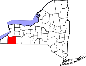 | |
| Towns |
| |
| Villages | ||
| CDPs | ||
| Other hamlets | ||
| Indian reservations | ||
| Footnotes |
| |
| Principal city |  | |
|---|---|---|
| Other major cities | ||
| Counties | ||