Provinces of Japan
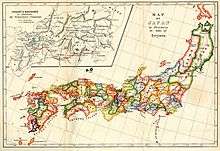
Provinces of Japan (令制国 Ryōseikoku) were administrative divisions before the modern prefecture system was established, when the islands of Japan were divided into tens of kuni (国, countries), usually known in English as provinces.[1] Each province was divided into gun (郡, districts, earlier called kōri).
History
The provinces were originally established by Ritsuryō as both administrative units and geographic regions.
In the late Muromachi period, however, their function was gradually supplanted by the domains of the sengoku-daimyo. Under the rule of Toyotomi Hideyoshi, the provinces were supplemented as primary local administrative units. The local daimyo's fiefs were developed.[2]
Edo period
In the Edo period, the fiefs became known as han. Imperial provinces and shogunal domains made up complementary systems. For example, when the shogun ordered daimyo to make a census or to make maps, the work was organized in terms of the boundaries of the provincial kuni.[3]
Meiji period
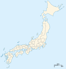
At the Meiji restoration, the han were legitimized as administrative units under Fuhanken Sanchisei, but were gradually replaced by prefectures between 1868 and 1871 (urban prefectures were called fu and rural prefectures ken). Provinces as part of the system of addresses were not abolished but, on the contrary, augmented. As of 1871, the number of prefectures was 304, while the number of provinces was 68, not including Hokkaidō or the Ryūkyū Islands. The boundaries between the many prefectures were not only very complicated, but also did not match those of the provinces. Prefectures were gradually merged to reduce the number to 37 by 1881; a few were then divided to give a total of 45 by 1885. Adding Hokkaidō and Okinawa produced the current total of 47 prefectures.
Provinces are classified into Kinai (within the capital), and seven or eight dō (routes, or circuits), collectively known as the Gokishichidō. However, dō in this context should not be confused with modern traffic lines such as Tōkaidō from Tokyo to Kyoto or Kobe. Also, Hokkaidō in this context should not be confused with Hokkaidō Prefecture, although these two overlap geographically.
Today
To date, no official order has been issued abolishing provinces. Provinces are nonetheless today considered obsolete, although their names are still widely used in names of natural features, company names, and brands. In the early 2000s, former governor of Nagano Prefecture, Yasuo Tanaka (president of New Party Nippon), proposed the renaming of his prefecture to "Shinshū" (信州, a name derived from Shinano Province) because it is still widely used, as in Shinshū soba (信州そば), Shinshū miso (信州味噌) and Shinshu University.
These province names are considered to be mainly of historical interest. They are also used for the names of items, including family names, most of which were popularized in or after the Edo period. Examples include sanuki udon, iyokan, tosa ken, and awa odori. Japan Rail stations also use them in names to, aside from the historical background, distinguish themselves from similarly named stations in other prefectures.
Some of the province names are used to indicate distinct parts of the current prefectures along with their cultural and geographical characteristics. In many cases these names are also in use with directional characters, e.g. Hoku-Setsu (北摂) meaning Northern (北) Settsu (摂津) area.
The districts are still considered prefectural subdivisions, however in case of being part of a merger or division of old provinces, they may be shared among several prefectures (such as the original Adachi District of Musashi, which is now divided between Adachi Ward of Tokyo and Kita-Adachi District in Saitama). Many of these old provincial districts have been dissolved as their chief towns have merged into larger cities or towns. See individual prefecture pages for mergers and abolitions of districts.
See also
Notes
- ↑ Nussbaum, Louis-Frédéric. (2005). "Provinces and prefectures" in Japan Encyclopedia, p. 780, p. 780, at Google Books.
- ↑ Mass, Jeffrey P. and William B. Hauser. (1987). The Bakufu in Japanese History, p. 150.
- ↑ Roberts, Luke S. (2002). Mercantilism in a Japanese Domain: the merchant origins of economic nationalism in 18th-century Tosa, p. 6; excerpt, "Imperial provinces "remained on the cultural map as commonly used definers of territorial regions called kuni ... because when the shogun ordered populations registers and maps to be made, he had them organized along the borders of the provincial kuni. This has been interpreted as important evidence of the shogun's styled role as a servant of the emperor, one of the important means by which he legitimized his authority."
References
- Nussbaum, Louis-Frédéric and Käthe Roth. (2005). Japan encyclopedia. Cambridge: Harvard University Press. ISBN 978-0-674-01753-5; OCLC 58053128
External links
Detailed maps of the provinces at different times can be found at: