Old San Juan
| Old San Juan Viejo San Juan | |
|---|---|
| Barrio of the Municipality of San Juan | |
|
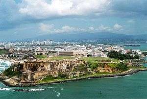
Aerial view of Fort San Felipe del Morro and Old San Juan | |
| Nickname(s): La Ciudad Amurallada (The Walled City), Ciudad Capital (Capital City) | |
|
Motto: "Por su constancia, amor y fidelidad, es muy noble y muy leal esta ciudad" ("For its perseverance, love and fidelity, this city is very noble and very loyal") | |
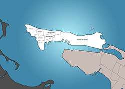
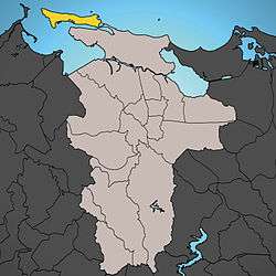 Location of Old San Juan (in yellow) within the city of San Juan. | |
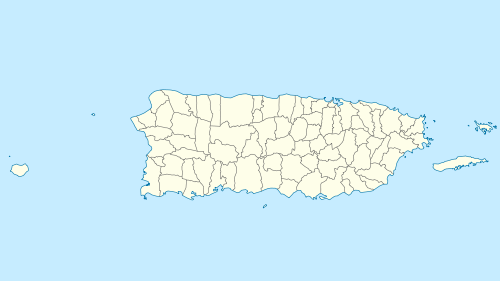 Old San Juan Location in Puerto Rico | |
| Coordinates: 18°27′59″N 66°6′37″W / 18.46639°N 66.11028°WCoordinates: 18°27′59″N 66°6′37″W / 18.46639°N 66.11028°W | |
| Country |
|
| Territory |
|
| Established | 1509[1] |
| Time zone | AST (no daylight saving time) (UTC-4) |
| ZIP codes | 00901-02 |
| Area code | 787, 939 |
| Sub-barrios (Districts) | Ballajá, Catedral, Marina, Mercado, Puerta de Tierra, San Cristóbal, San Francisco |
| Website | |
| Official name | La Fortaleza and San Juan National Historic Site in Puerto Rico |
| Type | Cultural |
| Criteria | vi |
| Designated | 1983 (7th session) |
| Reference no. | 266 |
| State Party |
|
| Region | The Americas |
| Official name | Zona Histórica de San Juan |
| Designated | October 10, 1972 |
| Reference no. | 72001553[2] |
| Location | NW triangle of the islet of San Juan, San Juan, Puerto Rico |
| Governing body | State |
Old San Juan (Spanish: Viejo San Juan) is the oldest settlement within Puerto Rico and the historic colonial section of the city of San Juan. The settlement is a National Historic Landmark District and was listed on the National Register of Historic Places as the "Zona Histórica de San Juan" (English: San Juan Historic Site).[2]
Location
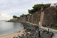
Old San Juan is located on a small and narrow island which lies along the north coast, about 35 miles (56 km) from the east end of Puerto Rico, and is united to the mainland of Puerto Rico by three bridges. It is bounded by the Atlantic Ocean to the north and to the south by San Juan Bay (or "Bahia de San Juan")—which lies between the city and the mainland. On a bluff about 100 feet (30 m) high at the west end of the island and commanding the entrance to the harbor, rise the battlements of Fort San Felipe del Morro, in which there is a lighthouse.
The "Caño de San Antonio" lies to the southeast, where the island of Old San Juan connects to the mainland through Santurce, by three bridges, "Puente Dos Hermanos" (Ashford Avenue), "Puente G. Esteves" (Ponce de León Avenue) and "Puente San Antonio" (Fernández Juncos Avenue).
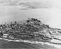
The city is characterized by its narrow, blue cobblestone streets, and flat roofed brick and stone buildings which date back to the 16th and 17th century—when Puerto Rico was a Spanish possession. Near Fort San Felipe del Morro, is the Casa Blanca, a palace built on land which belonged to the family of Ponce de Leon.
History
Origins
In 1508, Juan Ponce de León founded the original settlement, Caparra[3] (named after the Province of Cáceres, Spain, birthplace of the then-governor of Spain's Caribbean territories, Nicolás de Ovando). The ruins of Caparra are known as the Pueblo Viejo sector of Guaynabo, behind the almost land-locked harbor just to the west of the present San Juan metropolitan area. In 1509, the settlement was abandoned and moved to a site which was called at the time "Puerto Rico" (meaning "rich port" or "good port"), a name that evoked that of a similar geographical harbor in the island of Gran Canaria, Canary Islands. In 1521, the name "San Juan" was added, and the newer settlement was given its formal name of "San Juan Bautista de Puerto Rico", following the usual custom of christening the town with both its formal name and the name which Christopher Columbus had originally given the islands, honoring John the Baptist.
Expansion and growth
Constructed in 1521, Casa Blanca served as the first fortification of the settlement and residence of Juan Ponce de León descendants, until the mid-eighteenth century.[4][5][6]
Prior to the 19th century, the area outside the city walls occupying the east side of Old San Juan Island, was almost uninhabited. In 1838 the so-called area of Puerta de Tierra (or "Land Gate") had a population of 168 residents, mainly of African descent.[7] According to a census made in 1846, the population had risen to 223 inhabitants living in 58 houses. On March 3, 1865, the municipal government of San Juan approved a resolution promoting the city expansion across the Puerta de Tierra which included the plan for demolishing the city walls along the eastern side.[8] On May 28, 1897, the wall demolition was officially started after a proclamation was issued by Queen Maria Christina.[7] By the year 1899, the population of Puerta de Tierra had risen to 5,453; while the area comprising the old walled city had a civilian population of roughly 18,103 inhabitants.
Maintaining architectural integrity
During the late 1940s, disrepair in the old city was evident. The local authorities were considering development proposals for renovating the old city and incorporating modern architecture on new constructions. Anthropologist Ricardo Alegría vehemently advised against the idea of razing old colonial buildings in favor of contemporary building designs. He followed the example suggested by his father, a local civic leader who had successfully prevented the demolition of the Capilla del Cristo in favor of a traffic redesign. He advised mayor Rincón de Gautier in having local zoning laws changed to favor remodeling and the incorporation of Spanish colonial motifs in any new construction. This helped preserve the city's architectural profile, and has been a key to San Juan's current status as a tourist destination.
-
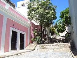
Traditional callejón in Old San Juan
-
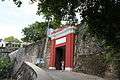
The gate to the city
Later, when Luis Muñoz Marín became governor of Puerto Rico, and the Institute of Puerto Rican Culture (Instituto de Cultura Puertorriqueña) was founded, Alegría—then named its first director—sought legal and administrative changes that would allow for major remodeling efforts to be successful. At the time, most real estate in Old San Juan had devalued under appraised values because the city was perceived as unsafe (particularly because of building disrepair and social ills such as prostitution) and not profitable for business (because of rent control statutes, as well as the reluctance of commercial banks to fund remodelings). Under combined efforts by the institute and the Government Development Bank for Puerto Rico, "model" remodelings were made to show potential property owners how their renewed properties could look. The Bank provided low interest loans to remodelers, and the government gave triple tax exemptions to commercial activities in the old city (they were exempted for a limited time, not only from property taxes and municipal taxes, but from income tax from activities generated in their properties as well). At least one retailer from the shopping district in Charlotte Amalie was given incentives to set up shop in the Calle del Cristo (the city's red light district during the early 1940s) in order to persuade other retailers to follow suit and somehow "clean up" the district. Potential developers were offered sketches of their properties after a remodeling, as to suggest which architectural elements to improve or change. These efforts, however, did not prevent some city blocks from being razed.
Strict remodeling codes were implemented to prevent new constructions from affecting the common colonial Spanish architectural themes of the old city. There was a strong push to develop Old San Juan as a "small Manhattan". When a project proposal suggested that the old Carmelite Convent in San Juan be demolished to erect a new hotel, the Institute had the building declared a historic building, and asked that it be converted to a hotel in a renewed facility. This was what became the Hotel El Convento in Old San Juan.
The paradigm to reconstruct and renovate the old city and revitalize it has been followed by other cities in Latin America, particularly Havana, Lima and Cartagena de Indias.
Historic designations
The San Juan National Historic Site was established in 1949 to preserve historic buildings and other fortifications in Old San Juan. The historic site was added to the National Register of Historic Places in 1966.[2] La Fortaleza along with the San Juan National Historic Site were then declared a World Heritage Site by UNESCO (United Nations Educational, Scientific, and Cultural Organization) in 1983.[9]
Today
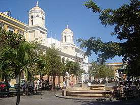
With its abundance of shops, historic places, museums, open air cafés, restaurants, gracious homes, tree-shaded plazas, and its old beauty and architectural peculiarity, Old San Juan is a main spot for local and internal tourism. A free tourist trolley serves the city.
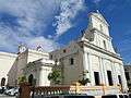
The neighborhood of La Perla outside of the historic city wall on the rocky north coast belongs to sub-barrios Mercado and San Cristóbal. The district is characterized by numerous public plazas and churches including San José Church and the Cathedral of San Juan Bautista, which contains the tomb of the Spanish explorer Juan Ponce de León. It also houses the most ancient Catholic school for Elementary education in Puerto Rico, the Colegio de Párvulos, built in 1865.
Old San Juan is one of the two barrios, in addition to Santurce, that made up the municipality of San Juan after 1864 and prior to 1951, in which the former independent municipality of Río Piedras was annexed.
Blockhouses and sub-barrios
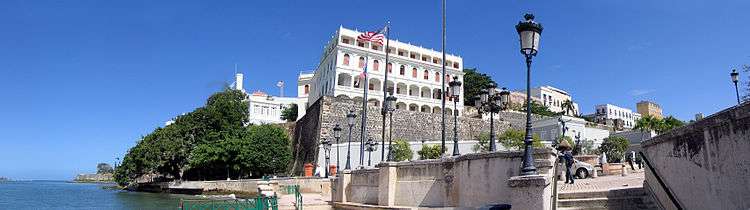
The oldest parts of the district of Old San Juan remain partly enclosed by massive walls. Several defensive structures and notable forts, such as the Fort San Felipe del Morro, Fort San Cristóbal, and El Palacio de Santa Catalina (also known as La Fortaleza), acted as the primary defense of the settlement which has been subjected to numerous attacks. La Fortaleza continues to serve also as the executive mansion for the Governor of Puerto Rico. Many of the historic fortifications are part of San Juan National Historic Site.
Public transportation
Old San Juan is the location for one of two transportation hubs serving Metropolitan San Juan.[10] A free trolley provides limited service to Old San Juan seven days a week.[11]
See also
- List of United States National Historic Landmarks in United States commonwealths and territories, associated states, and foreign states
- National Register of Historic Places listings in metropolitan San Juan, Puerto Rico
References
- ↑ San Juan, Ciudad Capital. SanJuan.pr. Retrieved 2010-12-22.
- 1 2 3 National Park Service (2009-03-13). "National Register Information System". National Register of Historic Places. National Park Service.
- ↑ EB-Guaynabo-Puerto-Rico Guaynabo; [with a history of Puerto Rico]; "Encyclopædia Britannica"; 2006; Britannica.com webpage; Text: names Caparra, the first Spanish settlement of Puerto Rico (1508).
- ↑ (Spanish) San Juan: Historia Illustrada de su desarrollo urbano, 1508-1898 - Aníbal Sepúlveda Rivera. San Juan 1989. Centro de Investigaciones CARIMAR.
- ↑ (Spanish) San Juan Extramuros: Iconografia para su estudio - Aníbal Sepúlveda, Jorge Carbonell. San Juan 1990. Centro de Investigaciones CARIMAR / Oficina Estatal de Preservación Histórica.
- ↑ (English)A Conservation Master Plan for the World Heritage Site of Old San Juan; Prof. Martin E. Weaver
- 1 2 "Historia de Puerta de Tierra". Johnny Torres Rivera.
- ↑ "Breve Historia del Desarrollo Urbano de la Ciudad de San Juan Bautista, Ciudad Capital de Puerto Rico". Legislatura Municipal de San Juan.
- ↑ "La Fortaleza and San Juan National Historic Site". UNESCO. Retrieved November 25, 2012.
- ↑ http://www.labochinchosa.com/index.php/header-transportation?view=zhgooglemap&id=13&mapzoom=&placemarklistid=&explacemarklistid=&grouplistid=&categorylistid=¢erplacemarkid=¢erplacemarkaction=
- ↑ http://www.puertoricodaytrips.com/free-trolley-old-san-juan/
External links
| Wikimedia Commons has media related to Old San Juan. |
| Wikivoyage has a travel guide for San Juan (Puerto Rico)/Old San Juan. |
- U.S. Geological Survey Geographic Names Information System: El Viejo San Juan. Retrieved 2008-04-24.
- The Forts of Old San Juan:Guardians of the Caribbean, a National Park Service Teaching with Historic Places (TwHP) lesson plan
- UrbanKibbutz (Old San Juan)
| Topics | |
|---|---|
| Lists by states |
|
| Lists by insular areas | |
| Lists by associated states | |
| Other areas | |
| |
| Bigger Historic Centres |
|  |
|---|---|---|
| Spanish Missions concentrations |
| |
| Cathedrals | ||
| Churches and monateries | ||
| Fortresses | ||
| Bridges and roads | ||
| Other buildings types | ||
| Architecture types | ||
| Modern Revival Style | ||
Category | ||