Auld Bourtreebush
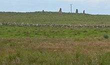
Auld Bourtreebush is a prehistoric stone circle in Aberdeenshire, Scotland. This megalithic construction is situated near the Causey Mounth ancient trackway, which connects the Scottish lowlands to the highlands.
Area history
Subsequent to the prehistory related to the construction of this stone circle, there is considerable medieval history associated with this monument's position along the ancient Causey Mounth trackway. Auld Bourtreebush is situated quite near to this old drovers' road, which was constructed on high ground to make passable this only available medieval route from coastal points south from Stonehaven to Aberdeen. This trackway specifically connected the River Dee crossing (where the present Bridge of Dee is situated) via Portlethen Moss, Muchalls Castle and Stonehaven to the south.[1] The route was that taken by William Keith, 7th Earl Marischal and the Marquess of Montrose when they led a Covenanter army of 9000 men in the battle of the Civil War in 1639.[2]
See also
References
- ↑ C.Michael Hogan, Causey Mounth, Megalithic Portal, ed. by A. Burnham, Nov 3, 2007
- ↑ Watt, Archibald, Highways and Byways around Kincardineshire, Stonehaven Heritage Society (1985)
Coordinates: 57°03′21″N 2°09′38″W / 57.0558°N 2.1606°W