Oklahoma Mesonet
|
| |
| Approved | 1990 |
|---|---|
| Funded | 1991[1] |
| Commissioned | January 1, 1994 |
| Headquarters | National Weather Center in Norman, OK |
| Partners | The University of Oklahoma, Oklahoma State University |
| Website | http://mesonet.org |
The Oklahoma Mesonet is a network of environmental monitoring stations designed to measure the environment at the size and duration of mesoscale weather events. The phrase "mesonet" is a portmanteau of the words mesoscale and network. In meteorology, “mesoscale” refers to weather events that range in size from one mile to 150 miles and can last from several minutes to several hours. Mesoscale events include thunderstorms, wind gusts, heat bursts and dry lines. Without densely spaced weather observations, these mesoscale events might go undetected.
The network consists of 121 automated stations covering Oklahoma and each of Oklahoma's counties has at least one station.[2] At each site, the environment is measured by a set of instruments located on or near a 10-meter (33 ft)-tall tower. The measurements are packaged into “observations” and transmitted to a central facility every 5 minutes, 24 hours per day, every day of the year.
Oklahoma Mesonet is a cooperative venture between Oklahoma State University and the University of Oklahoma (OU) and is supported by the taxpayers of Oklahoma. It is headquartered at the National Weather Center on the OU campus.
Observations are available free of charge to the public.
Background
According to the Tulsa World, creation of the Oklahoma Mesonet resulted from the inability of emergency management officials to plan for the May 26–27, 1984 flood that killed 14 people in the Tulsa area. The 1984 flood demonstrated that emergency managers could not receive accurate and adequate data quickly enough about the progress of flooding from airport radars, updated hourly. The University of Oklahoma and Oklahoma State University collaborated with the Climatological Survey and other public and private agencies to create the Oklahoma Mesonet. This system collects weather information (e.g., wind speed, rainfall, temperature) every 5 minutes from 121 Mesonet stations throughout Oklahoma. Emergency planners can now monitor up-to-date weather information in advance of the arrival of an approaching storm.[3] The article quoted an official of the Tulsa Area Emergency Management as saying that his staff uses the Oklahoma Mesonet every day.[3]
Meteorological Stations
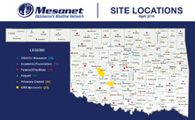
The Oklahoma Mesonet consists of 121 remote stations across Oklahoma with at least one station in each of Oklahoma's 77 counties. Each Oklahoma Mesonet station is contained within a 10m x 10m plot of land. Stations reside on a variety of locations including: University of Oklahoma and Oklahoma State University Research land, academic and foundation sites, federal/state/city land, airports, and privately owned property.
Each site is visited at least three times per year during one of the Spring, Summer, and Fall passes. Sites are also visited by site technicians when there is a problem with a sensor or with communications. Additionally, sites are visited by a vegetation technician to ensure that the station is not overgrown by native plants. All sites generate their own electricity from solar panels and communicate mainly via radios on the Oklahoma Law Enforcement Telecommunications System (OLETS).
Instruments

The Oklahoma Mesonet utilizes a variety of meteorological instruments to collect its observations. Observations are collected through a data logger within an enclosure and transmitted back to the National Weather Center for quality assurance, archival, and public dissemination.
Air Temperature and Related Measurements
- Air Temperature (1.5m) - Thermometrics Air Temperature 2004–Present; Vaisala HMP35C 1994-2003
- Air Temperature (9m) - Thermometrics Air Temperature
Wind Measurements
- Wind Speed (10m) - RM Young Wind Monitor
- Wind Direction (10m) - RM Young Wind Monitor
- Wind Speed (2m) - RM Young Wind Sentry
Moisture Measurements
- Rainfall - Met One Tipping-Bucket Rain Gauge
- Relative Humidity - Vaisala HMP45C
- Soil Moisture - Campbell Scientific 229 - L
Soil Temperature Measurements
- Soil Temperature - Thermocouple Sensor
Other Measurements
- Station Pressure - Vaisala Barometer
- Solar Radiation - Li-Cor Pyranometer
Variables Measured
Every five minutes
- Air temperature and relative humidity at 1.5 m (4.9 ft)
- Rainfall
- Barometric pressure
- Solar radiation
- Wind speed and direction at 10 m (33 ft)
Every 15 minutes
- Soil temperature under bare soil and natural sod at 5 cm (2.0 in) and 10 cm (3.9 in)
- Soil temperature under natural sod at 30 cm (12 in)
Every 30 minutes
- Soil moisture at 5 cm (2.0 in), 25 cm (9.8 in), and 60 cm (24 in)
Records
The following are records measured by the Oklahoma Mesonet since January 1, 1996.[4]
Temperature
- Highest Temperature: A record high temperature of 115 °F occurred multiple times in multiple locations across the state: Buffalo (7/9/2009), Erick and Hollis (6/26/2011), Wilburton and Wister (8/3/2011), and Kingfisher (8/1/2012).
- Highest Heat Index: On August 9, 1999, Calvin, Oklahoma (site now retired) experienced a heat index of 125 °F. That month, triple-digit temperatures were present somewhere in the state every day. At the time, this was the 19th warmest August in Oklahoma since 1892.
- Lowest Temperature: On February 10, 2011, Nowata, Oklahoma experienced a low temperature of -31 °F. One day prior to this, a massive winter storm concluded in the state. Reports of 6-12 inches of snow were widespread across the state and up to 21 inches of snow were reported in localized areas in the northeast. Blizzard conditions paralyzed travel and buried some locations in the north under 5–10 feet of snow.
- Lowest Wind Chill: On February 10, 2011, Medford, Oklahoma experienced a lowest wind chill of -47 °F. This extremely rare wind chill was accompanied by state-wide havoc as areas of Oklahoma experienced temperatures as low as -31 °F and up to 27 inches of snowfall in within 24 hours.
- Warmest Low Temperature: August 2012 took off with a record-breaking temperature of 115 °F in Kingfisher. Trailing closely behind were portions of north central Oklahoma at 114 °F. The majority of Oklahoma stayed near and above 110 °F for their maximum temperature, keeping minimum temperatures high. On August 2, 2012, Stillwater, Oklahoma experienced a warmest low temperature of 89 °F. The minimum temperatures allowed for little relief across the state.
- Coldest High Temperature: A massive winter storm bringing sleet and freezing rain quickly turned to snow overnight and continued through the day. Winds gusted over 50 mph over much of the state, combining with the snow to create true blizzard conditions. Frigid temperatures added to the storms impacts. Wind chill temperatures plummeted to less than -20 °F, keeping the high temperatures in the teens. On February 2, 2011, Kenton, Oklahoma experienced a coldest high temperature of 4 °F.
- Longest Stretch of Consecutive Hours Below Freezing: The longest stretch of consecutive hours below freezing occurred in Vinita, Oklahoma from December 23, 2000 to January 4, 2001. During this period 282 consecutive hours (11 Days, 18 hours) passed before the temperature rose above 32 °F.
- Days with High Temperatures above 100 °F - In 2011, Grandfield set a state record by experiencing 101 days with temperatures above 100 °F. 2011 brought with it the hottest summer in Oklahoma history.
- Hottest Summer in Oklahoma - The hottest summer in Oklahoma history occurred during June through August in 2011 with an average high temperature of 100.5 °F.
- Days with Consecutive High Temps Above 100 °F - For 50 consecutive days, the sites of Walters, Tipton, Hollis, Grandfield, and Altus recorded temperatures above 100 °F. This occurred from June 22 to August 10, 2011.
- Greatest 7 Day Temperature Change - On February 10, 2011, a cooling trend ensued and a passing band of snow and sleet came through Oklahoma. After several days of frigid temperatures, a warming trend brought with it climbing high temperatures and in seven days the temperature at Nowata went from -31 °F to 79 °F from February 10 to February 17, 2011, a change of 110 °F.
- Greatest 1 hour Temperature Change - On March 8, 2002, the temperature at May Ranch dropped from 74 °F to 34 °F in a single hour making that the greatest 1 hour temperature change ever recorded by the Mesonet.
Rainfall
- Greatest 1 hour Rainfall - On June 14, 1996, Cheyenne, Oklahoma experienced an unprecedented 6.78 inches of rain in a single hour. Caused by a slow moving, localized thunderstorm, Cheyenne and other nearby stations recorded large amounts of rainfall between June 12 and June 17, but the state still remained below average for June precipitation that year.
- Highest Annual Rain - In 2009, Broken Bow, Oklahoma experience the highest annual rainfall ever recorded by the Mesonet with 76.61 inches of rainfall.
- Lowest Annual Rain - In 2011, the site of Hooker, Oklahoma experienced the lowest annual rainfall of 6.23 inches.
- Highest 1 Day Rainfall - The stormiest period of 2009 began in late April with multiple storms occurring between April 25 and 30. On April 29, three tornadoes touched down, but the big story was the rainfall in southern Oklahoma. The Mesonet station at Burneyville recorded 12.42 inches of rainfall on the 29th and 30th, breaking several records. Other stations in the area had upwards of 7 inches during the same event.
Wind Speed
- Windiest Day Across Oklahoma - On February 24, 2007, storms from the Texas Panhandle quickly moved into western Oklahoma and eastward overnight. As the dry line and cold front passed through the state, severe non-thunderstorm winds gusted to over 60 mph. Blowing dust and power outages resulted. It would become the windiest day across the entire state as the average measured wind gust of every Mesonet site was 52.2 mph.
- Highest Wind Gust - On May 24, 2011, tornadic supercells raced across western, central, and eastern Oklahoma. The day included several violent EF-4 tornadoes and an EF-5 twister that struck the Oklahoma Mesonet site northwest of El Reno. The Mesonet station registered a maximum wind gust of 151 mph as well as a large and sudden pressure drop associated with the tornado. It caused significant and catastrophic damage along its path - killing nine people.
Products
The Oklahoma Mesonet produces many products public use. Every five minutes, maps of all of the meteorological variables are updated to show the latest observations. Users can also look at time series plots of a station (called meteograms[5]) over a given period of time. Quality assured data files[6] are available to be downloaded. Historical data can be plotted using the Oklahoma Mesonet's Long Term Average tools.[7][8] Here are a few examples of the many products produced by the Oklahoma Mesonet.
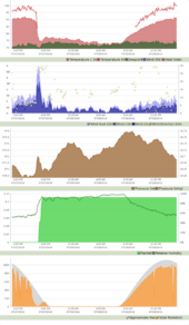 |
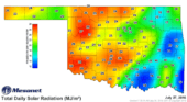 |
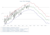 |
Programs
The Oklahoma Mesonet runs a variety of programs[9] to assist the public.
- Public Safety - OK-First[10] has been recognized for its innovative approach in providing instant access to a wealth of vital weather data for public safety agencies. A winner of Harvard University’s Innovations in American Government Award in 2001, OK-First also provides instructional resources for the public safety community. The information available through OK-First is critical for the protection of life and property, as evidenced by the tornado outbreak of May 3, 1999 and numerous flooding, winter weather, and wildfire events.
- Agriculture - Agweather[11] is a cooperative project between Oklahoma State University, the University of Oklahoma, and the Oklahoma Climatological Survey. The professionals and faculty from these three institutions bring together expertise in the areas of meteorology, climatology, agricultural production, and natural resource management. This professional team works together to provide Oklahoma citizens with the Oklahoma Mesonet, one of the finest weather data collection and reporting systems in the world. The Oklahoma Mesonet brings together the expertise from Oklahoma’s two major universities to create a single winning Oklahoma team.
- K-12 Education - OCS provides accurate, useful, and exciting learning activities using meteorology, environmental data, high quality software, and telecommunications. OCS staff have been working side-by-side with Oklahoma teachers since 1992 to help bring real-time weather data to even the most rural of schools.[12]
- Wildland Fire Management - OK-FIRE[13] is a weather-based decision support system which has been developed for wildland fire managers throughout Oklahoma. Applications include both wildfire and prescribed fire. Users include the USDA Forest Service, Bureau of Indian Affairs, US Fish and Wildlife Service, National Park Service, US Army Corps of Engineers, Natural Resources Conservation Service, National Weather Service, Oklahoma Forestry Services Division, The Nature Conservancy, fire departments, emergency managers, and private landowners. OK-FIRE products utilize the Oklahoma Mesonet, the state’s automated weather station network, and the National Weather Service’s 84-hour North American Mesoscale (NAM) model. OK-FIRE has a three-fold emphasis: (1) a comprehensive suite of products for fire weather, fire danger, and smoke dispersion which incorporate an 84-hour predictive component; (2) a dedicated OK-FIRE wildland fire management web site to act as the delivery mechanism for the above products; and (3) regional training and customer support activities for users. Funding to develop OK-FIRE was initially provided by a federal grant in 2005 (# 05-2-1-81) from the Joint Fire Science Program. Dr. J. D. Carlson (Biosystems and Agricultural Engineering, OSU, Stillwater) was PI on the grant and Dr. Terry Bidwell (Natural Resource Ecology and Management, OSU, Stillwater), the co-PI. OK-FIRE is now an established program of the Oklahoma Mesonet.
- Research - The Oklahoma Mesonet conducts cutting edge research utilizing its high resolution and research quality data. From data mining and statistical analyses to field projects and instrument evaluations, the Mesonet strives to better understand Oklahoma’s dynamic weather and remain abreast of new meteorological technologies.[14]
Mobile Applications
The Oklahoma Mesonet data can be viewed on iOS and Android smartphones through the use of the Mesonet's free application.
Features:
- Get live weather observations from 121 Mesonet weather stations across the state.
- Use your phone's built-in GPS to determine the closest weather station to your location.
- Check out 5-day forecasts for 120 locations across Oklahoma, updated every hour with the latest National Weather Service products.
- Access maps of air temperature, rainfall, winds, dew point, humidity, soil temperature, soil moisture, pressure, solar radiation, satellite, and upper air.
- View advisories for severe weather, fire weather, flooding, high wind, heat, winter storms, frost/freeze, ice, snow, and visibility.
- Animate live NEXRAD radar data from the Oklahoma City, Tulsa, Frederick, Enid, and other radars surrounding Oklahoma.
- Read the Mesonet Ticker news feeds.
Download:
See also
Flooding and flood control in Tulsa
References
- ↑ http://www.newson6.com/story/7716037/multi-purpose-weather-monitor-system-at-home-in-oklahoma
- ↑ McPherson, R. A., C. Fiebrich, K. C. Crawford, R. L. Elliott, J. R. Kilby, D. L. Grimsley, J. E. Martinez, J. B. Basara, B. G. Illston, D. A. Morris, K. A. Kloesel, S. J. Stadler, A. D. Melvin, A.J. Sutherland, and H. Shrivastava, 2007: Statewide monitoring of the mesoscale environment: A technical update on the Oklahoma Mesonet. J. Atmos. Oceanic Tech., 24, 301-321.
- 1 2 Peterson, Althea. "Oklahoma Mesonet had roots in the 1984 Memorial weekend flooding." Tulsa World. May 27, 2014. Retrieved June 19, 2014.
- ↑ http://www.mesonet.org/20th/
- ↑ http://www.mesonet.org/index.php/weather/meteogram/
- ↑ http://www.mesonet.org/index.php/weather/category/past_data_files
- ↑ http://www.mesonet.org/index.php/weather/mesonet_averages_graphs#series%5B%5D=nrmn%3Atair_av%3Acurrent%3AN%3A0%3A%23000000%3AN%3A1&series%5B%5D=nrmn%3Atair_mx%3Aaverage%3AN%3A5%3A%23990000%3AN%3A1&series%5B%5D=nrmn%3Atair_av%3Aaverage%3AN%3A5%3A%23006600%3AN%3A1&series%5B%5D=nrmn%3Atair_mn%3Aaverage%3AN%3A5%3A%23000066%3AN%3A1
- ↑ http://www.mesonet.org/index.php/weather/mesonet_averages_maps
- ↑ http://www.mesonet.org/index.php/site/programs
- ↑ http://www.mesonet.org/index.php/okfirst
- ↑ http://www.mesonet.org/index.php/agriculture/monitor
- ↑ http://www.mesonet.org/index.php/earthstorm
- ↑ http://okfire.mesonet.org/
- ↑ http://www.mesonet.org/index.php/site/research