Okhotsk Plate
| Okhotsk Plate | |
|---|---|
 | |
| Type | Minor |
| Movement1 | south-west |
| Speed1 | 13-14mm/year |
| Features | Kamchatka Peninsula, Sakhalin Island, Sea of Okhotsk |
| 1Relative to the African Plate | |
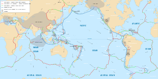
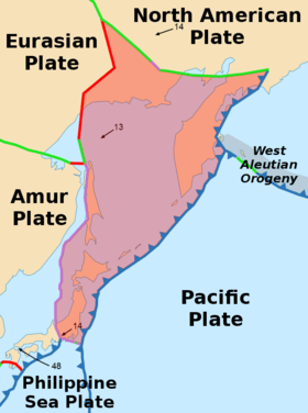
The Okhotsk Plate is a minor tectonic plate covering the Sea of Okhotsk, the Kamchatka Peninsula, Sakhalin Island and Tōhoku and Hokkaidō in Japan. It was formerly considered a part of the North American Plate, but recent studies indicate that it is an independent plate, bounded on the north by the North American Plate.[1] The boundary is a left-lateral moving transform fault, the Ulakhan Fault. On the east, the plate is bounded by the Pacific Plate at the Kuril-Kamchatka Trench and the Japan Trench, on the south by the Philippine Sea Plate at the Nankai Trough, on the west by the Eurasian Plate, and possibly on the southwest by the Amurian Plate.[2]
Geology
The boundary between Okhotsk Plate and Amurian Plate might be responsible for many strong earthquakes that occurred in the Sea of Japan as well as in the Sakhalin island, such as the MW7.1 (MS7.5 according to other sources) earthquake of May 27, 1995 in northern Sakhalin.[3][4][5] The earthquake devastated Neftegorsk, and the town was not rebuilt after the earthquake. Other notable intraplate earthquakes such as the 1983 Sea of Japan earthquake and the 1993 Hokkaidō earthquake triggered tsunamis in the Sea of Japan.
The boundary between Okhotsk Plate and Pacific Plate is a subduction zone, where Pacific Plate subducts beneath the Okhotsk Plate. Many strong megathrust earthquakes occurred here, some of them among the largest on world record, including the Kamchatka earthquakes of 1737 (estimated M9.0~9.3) and 1952 (M9.0). Such strong megathrust earthquakes can also occur near the Kuril Islands, as the M8.3 earthquake of November 15, 2006,[6][7] Hokkaido, as the M8.3 earthquake of September 26, 2003[8][9] and the M9.0 2011 Tōhoku earthquake off the coast of Honshu.
GPS measurements and other studies show that the Okhotsk Plate is slowly rotating in a clockwise direction. Models indicate that it rotates 0.2 deg/Myr about a pole located north of Sakhalin.[10]
References
- ↑ Apel et al., 2006; and Seno et al., 1996 http://onlinelibrary.wiley.com/wol1/doi/10.1029/2006GL026077/full
- ↑ http://www.stephan-mueller-spec-publ-ser.net/4/147/2009/smsps-4-147-2009.pdf
- ↑ Tamura, Makoto; et al. (2002). "The ShalIow Seismicity in the Southern Part of Sakhalin" (PDF). Geophysical Bulletin of Hokkaido University. 65: 127–142.
- ↑ "Earthquake Information for 1995". USGS.
- ↑ Arefiev, S. S.; et al. (2006). "Deep structure and tomographic imaging of strong earthquake source zones". Izvestiya Physics of the solid Earth. 42 (10): 850–863. Bibcode:2006IzPSE..42..850A. doi:10.1134/S1069351306100090.
- ↑ "IEEE Xplore Abstract - Offshore Tsunami Observation by the Kuril Islands Earthquake of 15 November 2006" (PDF). Ieeexplore.ieee.org. doi:10.1109/UT.2007.370767. Retrieved 2016-01-01.
- ↑ "Magnitude 8.3 - KURIL ISLANDS". Earthquake.usgs.gov. Retrieved 2016-01-01.
- ↑ Watanabe, Tomoki; et al. (2006). "Seismological monitoring on the 2003 Tokachi-oki earthquake, derived from off Kushiro permanent cabled OBSs and land-based observations". Tectonophysics. 426 (1–2): 107–118. Bibcode:2006Tectp.426..107W. doi:10.1016/j.tecto.2006.02.016.
- ↑ "Magnitude 8.3 - HOKKAIDO, JAPAN REGION". Earthquake.usgs.gov. Retrieved 2016-01-01.
- ↑ Apel, et al., 2006
External links
- Okhotsk Plate Modeling
- Joint US-Russia Workshop on the Plate Tectonic Evolution of Northeast Russia, Dec. 2004