Okahandja
| Okahandja | |
|---|---|
| City | |
| Motto: Semper Prorsum | |
 Okahandja Location in Namibia | |
| Coordinates: 21°59′S 16°55′E / 21.983°S 16.917°E | |
| Country |
|
| Region | Otjozondjupa Region |
| Constituency | Okahandja constituency |
| Population (2011)[1] | |
| • Total | 22,639 |
| Time zone | South African Standard Time (UTC+1) |
| Climate | BSh |
Okahandja is a city[2] of 24,100 inhabitants in Otjozondjupa Region, central Namibia, and the district capital of the Okahandja electoral constituency. It is known as the Garden Town of Namibia. It is located 70 km north of Windhoek on the B1 road. It was founded around 1800, by two local groups, the Herero and the Nama.[3]
History
Okahandja means the place where two rivers flow into each other to form one wide one in Otjiherero.[3]
A German pastor, Heinrich Schmelen, became the first European to visit the town in 1827.[4] In 1844, two missionaries were permanently assigned to the town, and a church dates from this period. A military post was established in Okahandja in 1894, and it is this date that is officially recognized as the town's founding.[5]
Maharero and his sons, Jan Jonker Afrikaner, Hosea Kutako and Clemens Kapuuo are buried in the town.
Economy
Okahandja's population is growing rapidly. It stood at just over 14,000 as measured by the 2001 Population and Housing Census, and is estimated to have surpassed 24,000 in 2012.[6][7]
Von Bach Dam is situated outside of Okahandja. It provides the majority of Windhoek's water. An open-air curio market attracts tourists, and the town serves as the administrative centre for the Herero people.
Transport
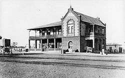

A station on the Trans-Namib Railway was built in 1909, which led to further growth and development in the area.
Education
In the 1870s Rhenish missionaries established the first school. The Augustineum School was reopened at Okahandja on 9 November 1905; it was later moved to Windhoek. Today Okahandja has six primary schools and two high schools. Namwater Vocational, situated outside the main town, is the only institute of higher education in Okahandja.
The National Institute for Educational Development (NIED) is today situated in Okahandja. NIED was created after independence as the institute from where a new national system of education was created, replacing the previous racist system of apartheid.
Previously the German school Regierungsschule Okahandja was in the city.[8]
Politics
Okahandja is governed by a municipal council that currently has seven seats.[9]
Local authority results, 2010
In the 2010 local authority election in Okahandja, SWAPO won with approximately 62% of the vote. Of the five other parties seeking votes in the election, RDP received approximately 13% of the vote, followed by the UDF (8%), the UPM (7%), NUDO (6%) and DTA (2%).[10]
Sport
In the 1970s, Okahandja Soccer Club had a competitive football team that won several competitions.[11]
In addition, local club Liverpool Okahandja were NFA-Cup winners in 1992 and Namibia Premier League champions in 2002.
See also
References
- ↑ "Table 4.2.2 Urban population by Census years (2001 and 2011)" (PDF). Namibia 2011 - Population and Housing Census Main Report. Namibia Statistics Agency. p. 39. Retrieved 24 August 2016.
- ↑ "Local Authorities". Association of Local Authorities in Namibia (ALAN). Retrieved 1 October 2012.
- 1 2 "Okahandja, a town in Namibia". The Cardboard Box. Retrieved 25 October 2010.
- ↑ Dierks, Klaus. "Biographies of Namibian Personalities, R-Z". Retrieved 27 March 2011.
- ↑ History of Okahandja Okahandja.net
- ↑ Republic of Namibia 2001 Population and Housing Census (Basic Analysis with Highlights ed.). Windhoek: Central Bureau of Statistics, National Planning Commission. July 2003. p. 21. ISBN 0-86976-614-7.
- ↑ Paulus, Paulus (24 September 2012). "Windhoek entombed in debt". New Era. allafrica.com.
- ↑ "Deutscher Bundestag 4. Wahlperiode Drucksache IV/3672" (Archived 2016-03-12 at WebCite). Bundestag (West Germany). 23 June 1965. Retrieved on 12 March 2016. p. 32/51.
- ↑ "Know Your Local Authority". Election Watch (3). Institute for Public Policy Research. 2015. p. 4.
- ↑ Local Authority Election Results for Okahandja
- ↑ Kambaekwa, Carlos (20 August 2010). "Alcino 'Shorty' da Costa - The Portuguese dynamo". New Era.
Coordinates: 21°59′S 16°55′E / 21.983°S 16.917°E