Ojiya, Niigata
| Ojiya 小千谷市 | |||
|---|---|---|---|
| City | |||
|
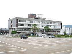
Ojiya City Hall | |||
| |||
 Location of Ojiya in Niigata | |||
 Ojiya
| |||
| Coordinates: 37°18′51.7″N 138°47′42.3″E / 37.314361°N 138.795083°ECoordinates: 37°18′51.7″N 138°47′42.3″E / 37.314361°N 138.795083°E | |||
| Country | Japan | ||
| Region | Chūbu (Kōshin'etsu) (Hokuriku) | ||
| Prefecture | NIigata | ||
| Area | |||
| • Total | 155.19 km2 (59.92 sq mi) | ||
| Population (June 2016) | |||
| • Total | 36,182 | ||
| • Density | 233/km2 (600/sq mi) | ||
| Time zone | Japan Standard Time (UTC+9) | ||
| Symbols | |||
| • Flower | Narcissus | ||
| • Fish | Japanese carp | ||
| Phone number | 0250-62-2510 | ||
| Address | 2-7-5 Jonai, Ojiya-shi, Niigata-ken 947-8501 | ||
| Website |
www | ||


Ojiya (小千谷市 Ojiya-shi) is a city located in north-central Niigata Prefecture, in the Hokuriku region of Japan. As of 1 June 2016, the city had an estimated population of 36,182 and a population density of 233 persons per km². Its total area was 155.19 square kilometres (59.92 sq mi).
Geography
Ojiya is located in an inland region of central Niigata Prefecture. The Shinano River flows through the city. The area has very heavy snow in winter.
Surrounding municipalities
History
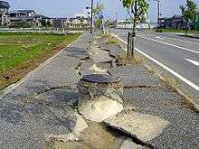
The area of present-day Ojiya was part of ancient Echigo Province. The modern town of Ojiya was established on April 1, 1889 with the establishment of the municipalities system, within Kitauonuma District. It was raised to city status on on March 10, 1954. On October 23, 2004, the Chūetsu earthquake struck Ojiya, causing shaking measured at Intensity 6+ on the Japan Meteorological Agency seismic intensity scale and causing fatalities. Electricity was cut off for three days after the earthquake.
Education
Ojiya has eight public elementary schools and five public middle schools. There are two public high school, and also one special education school.
Transportation
Railway
Highway
- Kan-Etsu Expressway – Ojiya IC
- Japan National Route 17
- Japan National Route 117
- Japan National Route 291
- Japan National Route 351
- Japan National Route 403
Local attractions
- Ojiya Balloon Festival
- Katakai Fireworks Festival
Notable people from Ojiya
- Junzaburō Nishiwaki, poet

External links
| Wikimedia Commons has media related to Ojiya, Niigata. |
- Ojiya City official website (Japanese)