Ojinaga Municipality
| Ojinaga | |
|---|---|
| Municipality | |
| Nickname(s): La perla del desierto | |
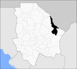 Municipality of Ojinaga in Chihuahua | |
|
Ojinaga Location in Mexico | |
| Coordinates: 29°34′N 104°25′W / 29.567°N 104.417°W | |
| Country |
|
| State | Chihuahua |
| Municipal seat | Ojinaga |
| Area | |
| • Total | 9,500.5 km2 (3,668.2 sq mi) |
| Population (2010) | |
| • Total | 26,304 |
| • Density | 2.8/km2 (7.2/sq mi) |
Ojinaga Municipality (formally: Manuel Ojinaga ) is one of the 67 municipalities of Chihuahua, in northern Mexico. The municipal seat lies at Ojinaga, a rural bordertown on the U.S.-Mexico border. The municipality has an area of 9,500.50 km² (3,668.16 sq mi).
Geography
Ojinaga, named after Juarista governor Manuel Ojinaga, reported a 2010 census population of 22,744 people in the town, which serves as municipal seat of the municipality of 26,304 inhabitants.[1] The municipality includes numerous very small outlying communities, the largest of which are El Oasis and Nueva Holanda.
Towns and villages
The municipality has 108 localities. The largest are:
| Name | 2010 Census Population[1] |
|---|---|
| Ojinaga | 22,744 |
| El Oasis | 475 |
| Nueva Holanda | 426 |
| La Esmeralda | 187 |
| Maijoma | 160 |
| Valverde | 143 |
| El Divisadero | 135 |
| El Mezquite | 120 |
| Potrero del Llano | 129 |
| Total Municipality | 26,304 |
Adjacent municipalities and counties
- Manuel Benavides Municipality - southeast
- Camargo Municipality - south
- Julimes Municipality - southwest
- Aldama Municipality - southwest
- Coyame del Sotol Municipality - west
- Guadalupe Municipality - northwest
- Presidio County, Texas - north and northeast
References
- 1 2 "Ojinaga". Catálogo de Localidades. Secretaría de Desarrollo Social (SEDESOL). Retrieved 23 April 2014.
- 2010 census tables: INEGI: Instituto Nacional de Estadística, Geografía e Informática
- Chihuahua Enciclopedia de los Municipios de México
External links
- Ojinaga Hoy
- La Perla del Desierto, local website
- Camino Minerals, Maijoma mine, Ojinaga Municipality
Coordinates: 29°34′N 104°25′W / 29.567°N 104.417°W
This article is issued from Wikipedia - version of the 9/4/2016. The text is available under the Creative Commons Attribution/Share Alike but additional terms may apply for the media files.