Ohio State Route 329
| |||||||
|---|---|---|---|---|---|---|---|
 | |||||||
| Route information | |||||||
| Maintained by ODOT | |||||||
| Length: | 23.80 mi[1] (38.30 km) | ||||||
| Existed: | 1932[2][3] – present | ||||||
| Major junctions | |||||||
| South end: |
| ||||||
| North end: |
| ||||||
| Location | |||||||
| Counties: | Athens, Morgan | ||||||
| Highway system | |||||||
| |||||||


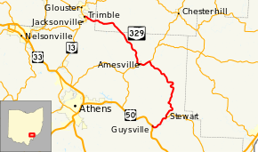
State Route 329 (SR 329) is a state highway located in southeastern Ohio. The route is signed as a north–south route though the shape of the road is more of a backwards C. The southern terminus of SR 329 is in the Rome Township community of Guysville at US 50 and SR 32. After traveling north through the Athens County communities of Stewart and Amesville, the route briefly enters Morgan County before re-entering Athens County and ending at SR 13 in the village of Trimble.[4]
History
SR 329 was certified and paved in 1932, originally routed from Guysville to Stewart, in southeast Ohio.[2][3] In 1937, the route was extended from Stewart to US 50 Alternate, 2 miles (3.2 km) east of Amesville.[5][6] In 1962, the highway was extended to Trimble, passing through Amesville and using the former route of SR 280.[7][8]
Major intersections
| County | Location | mi[1] | km | Destinations | Notes | |||
|---|---|---|---|---|---|---|---|---|
| Athens | Rome Township | 0.00 | 0.00 | |||||
| 2.38 | 3.83 | Northern terminus of SR 144 | ||||||
| Bern Township | 12.19 | 19.62 | Southern end of SR 550 concurrency | |||||
| Amesville | 13.66 | 21.98 | Northern end of SR 550 concurrency | |||||
| Morgan |
No major junctions | |||||||
| Athens | Trimble | 23.80 | 38.30 | |||||
1.000 mi = 1.609 km; 1.000 km = 0.621 mi
| ||||||||
References
- 1 2 Ohio Department of Transportation. "Technical Services Straight Line Diagrams". Retrieved April 30, 2010.
- 1 2 Map of Ohio Showing State Routes (MrSID) (Map). Cartography by ODHPW. Ohio Department of Highways and Public Works. 1931. Retrieved January 9, 2013.
- 1 2 Map of Ohio Showing State Routes (MrSID) (Map). Cartography by ODHPW. Ohio Department of Highways and Public Works. 1932. Retrieved January 9, 2013.
- ↑ Google (January 2, 2014). "Ohio State Route 329" (Map). Google Maps. Google. Retrieved January 2, 2014.
- ↑ Map of Ohio Showing State Routes (MrSID) (Map). Cartography by ODHPW. Ohio Department of Highways and Public Works. 1936. Retrieved January 9, 2013.
- ↑ Map of Ohio Showing State Routes (MrSID) (Map). Cartography by ODHPW. Ohio Department of Highways and Public Works. 1937. Retrieved January 9, 2013.
- ↑ Map of Ohio Showing State Routes (MrSID) (Map). Cartography by ODH. Ohio Department of Highways. 1961. Retrieved January 9, 2013.
- ↑ Map of Ohio Showing State Routes (MrSID) (Map). Cartography by ODH. Ohio Department of Highways. 1962. Retrieved January 9, 2013.