Ohio State Route 226
| |||||||
|---|---|---|---|---|---|---|---|
 | |||||||
| Route information | |||||||
| Maintained by ODOT | |||||||
| Length: | 14.83 mi[1] (23.87 km) | ||||||
| Existed: | 1929 – present | ||||||
| Major junctions | |||||||
| West end: |
| ||||||
| East end: |
| ||||||
| Location | |||||||
| Counties: | Holmes, Wayne | ||||||
| Highway system | |||||||
| |||||||

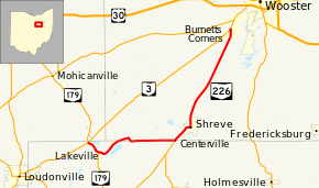
State Route 226 (SR 226) is an east–west state highway in the central part of the U.S. state of Ohio. The highway's western terminus is at the junction of State Route 3 and State Route 179 approximately 4.50 miles (7.24 km) northeast of Loudonville. Its eastern terminus is also at Ohio State Route 3, this time at an intersection nearly 1.75 miles (2.82 km) southwest of Wooster.
Route description
State Route 226 travels through the northwestern portion of Holmes County and the southwestern quadrant of Wayne County. There is no segment of State Route 226 that is incorporated within the National Highway System.[2]
History
State Route 226 was established in 1929. It was routed along the alignment that it maintains to this day, replacing what was designated as State Route 250. This was due to the designation of U.S. Route 250 in the state of Ohio in that same year. No changes of major significance have taken place to State Route 226 since its inception.[3][4]
Major intersections
| County | Location | mi[1] | km | Destinations | Notes | |||
|---|---|---|---|---|---|---|---|---|
| Holmes | Washington Township | 0.00 | 0.00 | Western end of SR 179 concurrency | ||||
| 0.97 | 1.56 | Eastern end of SR 179 concurrency | ||||||
| Wayne |
No major junctions | |||||||
| Holmes–Wayne county line | Ripley–Clinton township line | 6.47 | 10.41 | Northern terminus of SR 514 | ||||
| Wayne | Wooster Township | 14.83 | 23.87 | |||||
1.000 mi = 1.609 km; 1.000 km = 0.621 mi
| ||||||||
References
- 1 2 Ohio Department of Transportation. "Technical Services Straight Line Diagrams". Retrieved 2010-12-22.
- ↑ National Highway System: Ohio (PDF) (Map). Federal Highway Administration. December 2003. Retrieved 205-06-18. Check date values in:
|access-date=(help) - ↑ Ohio State Map (Map). Ohio Department of Transportation. 1928.
- ↑ Ohio State Map (Map). Ohio Department of Transportation. 1929.