Ohio State Route 315
| ||||
|---|---|---|---|---|
 | ||||
| Route information | ||||
| Maintained by ODOT | ||||
| Length: | 22.48 mi[1] (36.18 km) | |||
| Existed: | 1933 – present | |||
| Major junctions | ||||
| South end: |
| |||
|
| ||||
| North end: |
| |||
| Location | ||||
| Counties: | Franklin, Delaware | |||
| Highway system | ||||
| ||||

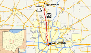
State Route 315, or known locally as the Olentangy Freeway, running almost parallel to Olentangy River Road for most of its length,[2] is a north–south highway in central Ohio, mainly in the Columbus metropolitan area. It may be seen abbreviated as SR 315, OH-315, or simply 315. Its southern terminus is at the south junction of I-70 and I-71 in Columbus, and its northern terminus is at US 23 near Delaware. It is a controlled access freeway from its southern terminus to I-270. The controlled access section carries two or three lanes in each direction, depending on the location. North of I-270, it becomes a two-lane road. It roughly follows the Olentangy River for about two-thirds of its length. The route passes near The Ohio State University campus.
The section between Interstate 670 and Interstate 70 is known as the West Innerbelt, and is commonly referred to as such in traffic reports. The original name of this section was Sandusky Street.
Route description
Lawrence E. Hughes Memorial Highway
Running in a north and south direction within Franklin county, commencing at the point where that state route crosses over King avenue and extending northward to the boundary of Franklin county and Delaware county.[3]

Exit list
| County | Location | mi[4][5] | km | Exit | Destinations | Notes |
|---|---|---|---|---|---|---|
| Franklin | Columbus | 0.00– 0.44 | 0.00– 0.71 | — | Mound-Sandusky Interchange; I-70 exit 99B; I-71 exit 106B. | |
| 0.51– 0.79 | 0.82– 1.27 | — | Split diamond interchange with one-way couplet | |||
| 0.92 | 1.48 | — | Southbound exit from I-670/US 33 ramps only; exit to West Broad Street from OH-315 southbound is prohibited. Access to Mount Carmel West Hospital | |||
| 1.21– 1.70 | 1.95– 2.74 | — | Northbound exit and southbound entrance; part of Spring Sandusky Interchange | |||
| 1.29– 1.66 | 2.08– 2.67 | — | Northbound-westbound and eastbound-southbound movements handled by US 33, Spring Sandusky Interchange; I-670 east to 315 north exit 2B, west exits 2A-B. | |||
| 1.97– 2.59 | 3.17– 4.17 | — | ||||
| 3.18– 3.26 | 5.12– 5.25 | — | Medical Center Drive/King Avenue | Northbound exit and southbound entrance; access to Ohio State University Wexner Medical Center | ||
| 3.69– 3.81 | 5.94– 6.13 | — | CR 9 (Olentangy River Road) / CR 176 (Kinnear Road) | Southbound exit and northbound entrance; southbound access to King Avenue, Fifth Avenue, and Third Avenue | ||
| 4.20– 4.49 | 6.76– 7.23 | — | CR 59 (Lane Avenue) | Access to Ohio State University, Ohio Stadium, Schottenstein Center and Upper Arlington | ||
| 5.03– 5.35 | 8.10– 8.61 | — | CR 52M (Ackerman Road) | |||
| 5.69– 6.52 | 9.16– 10.49 | — | Access to Riverside Methodist Hospital | |||
| 7.61– 8.11 | 12.25– 13.05 | — | CR 55 (Henderson Road) / CR 9 (Olentangy River Road) | |||
| 8.35– 8.83 | 13.44– 14.21 | — | CR 67 (Bethel Road) | |||
| Worthington | 10.22– 10.59 | 16.45– 17.04 | — | |||
| Sharon Township | 11.66– 12.28 | 18.76– 19.76 | — | I-270 exits 22A-B; Modified cloverleaf interchange. | ||
| 12.28 | 19.76 | Begin at-grade highway northbound and limited access highway southbound | ||||
| Delaware | Liberty Township | 15.22 | 24.49 | |||
| Delaware Township | 22.48 | 36.18 | Northern terminus of SR 315 | |||
1.000 mi = 1.609 km; 1.000 km = 0.621 mi
| ||||||
State Route 315C
| State Route 315C | |
|---|---|
| Location: | Columbus, Ohio |
| Length: | 1.09 mi[6] (1.75 km) |
An unsigned State Route 315C exists which begins on the I-670 westbound ramp to Neil Ave, follows Neil south to the Goodale-Neil Connector and Goodale Ave, then up Olentangy River Rd and onto the ramp to SR 315 southbound, where it ends. It is not clear from the Straight Line Diagram whether SR 315C exists in both directions, or westbound only.[6]
See also
List of unused highways in Ohio
References
- ↑ Ohio Department of Transportation. "Technical Services Straight Line Diagrams".
- ↑ Google (17 August 2013). "Olentangy Freeway" (Map). Google Maps. Google. Retrieved 17 August 2013.
- ↑ "Ohio Revised Code 5533.90".
- ↑ Ohio Department of Transportation. "Ohio State Route 315 - Straight Line Diagram - Franklin County" (PDF).
- ↑ Ohio Department of Transportation. "Ohio State Route 315 - Straight Line Diagram - Delaware County" (PDF).
- 1 2 Ohio Department of Transportation. "Route 315C Straight Line Diagram" (PDF).