Ocotal
| Ocotal La Sultana del Norte | |
|---|---|
| Municipality | |
|
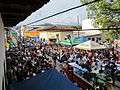
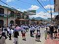
Downtown Ocotal | |
 Ocotal Location in Nicaragua | |
| Coordinates: 13°38′N 86°29′W / 13.633°N 86.483°W | |
| Country |
|
| Department | Nueva Segovia Department |
| Area | |
| • Municipality | 32.91 sq mi (85.23 km2) |
| Population (2005) | |
| • Municipality | 41,875 |
| • Urban | 34,190 |
| Climate | Aw |
Ocotal (Spanish pronunciation: [okoˈtal]) is the capital of the Nueva Segovia Department in Nicaragua, Central America.
History
In 1927, Ocotal suffered one of the first dive bombing attacks in history during a battle that pitted the American Marines and the Nicaraguan National Guard against Sandinista rebels. Ocotal is the same city that was founded by Spanish colonialists in 1543, with the name Nueva Segovia.
During the 2009 Honduran constitutional crisis, ousted Honduran president Manuel Zelaya set up a government-in-exile in the city briefly in July during reconciliation negotiations with coup leaders.
Description
Ocotal is the capital of the Nueva Segovia Department in Nicaragua. The main agricultural production is coffee. The city, which has a population of 39.450 (as of 2000), is located in a valley. The name comes from the native language word for pine resin, due to the local abundant pine ocote. It was the third Spanish colony (after León and Granada) founded in what would eventually be called the Province of Nicaragua and Costa Rica. Its original name was Nueva Ciudad Segovia (New Segovia) and credits for its foundation are given to Rodrigo de Contreras in 1543.
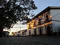
Attractions include the Dipilto-Jalapa Pine forests on the north, the Somoto Canyon on the south, the indigenous and artisan towns of Mozonte and Totogalpa, as well as multiple hiking opportunities around its picturesque mountains. The old town center boasts some of the oldest colonial homes in the region as well as a very well preserved central garden in the middle of the commercial center featuring hundreds of species of flowers and tropical plants. Due to its valley location and close proximity to Nicaragua's highest mountains, its climate remains safe from the extreme heat of the pacific. Some "yet-to-discover" activities also include hiking the majestic Cerro Guásara, letting the Coco River drag you down from "El Saltarin" all the way to the Ocotal Bridge, or simply visiting one of the many surrounding coffee farms while enjoying the landscape. A day trip to El Rosario Waterfalls from Ocotal is also worth considering.
Geography
Characterised by steep hills in the north and south, plateaus in the west and a valley in the center. It lies at an altitude of 500 metres (1,640 feet) above sea level.
Administration
There are 29 neighbourhoods: José Santos Rodríguez, Sandino, Hermanos Zamora, Teodoro López, Monseñor Madrigal, José Santos Duarte, Danilo Ponce, Yelba María Antúnez,Anexo Yelba María Antunez, Noel Weelock, Enrique Lacayo Farfán, Anexo Laura Sofía, Roberto Gómez Montalvan, Laura Sofía Olivas Paz, Nicarao, Leonardo Matute, 26 de septiembre, Santa Ana, Carlos Manuel Jarquin, Ramón Augusto López, Nora Astorga, Cristo del Rosario, Nuevo Amanecer, María Auxiliadora, Dinamarca, Pueblos unidos (where the Colonia del Maestro y 8 de mayo zones have been built).
10 Municipal zones containing 22 Administrative areas
Zone 1
|
Zone 3
|
Zone 5
|
Zone 7
|
Zone 9
|
Zone 2
|
Zone 4
|
Zone 6
|
Zone 8
|
Zone 10
|
Sport
Ocotal has a well known soccer team known as Deportivo Ocotal
International relations
Twin towns – Sister cities
Ocotal is twinned with:
Gallery
Coordinates: 13°38′N 86°29′W / 13.633°N 86.483°W
| Wikimedia Commons has media related to Ocotal. |


Map
A map of Ocotal is being created by the Openstreetmap project here
External links
| Wikimedia Commons has media related to Ocotal. |
- Radio Segovia
- Videos in Spanish and some English of Ocotal with links to the surrounding areas
- Brief outline of Ocotal 1999
- Swindon-Ocotal, History of Nicaragua and Ocotal from Twin town Swindon
- Battle of Ocotal
- Battle of Ocotal from Nicanews
- Groundwater study. Includes geography and history (.pdf)
- Home page of Deportivo Ocotal (in Spanish)
- Detailed information on the Sandino Rebellion, includes reports from the battle at Ocotal
- Nicaraguan Expat site
- More information on the central park (Spanish)
- La Gruta de la Virgen de Guadalupe - Ocotal, Nicaragua
- Urban planning - Hurricane Mitch
- Hurricane Mitch
- Report on Landmines Nicaragua page 123
Capital: Ocotal | ||
| Municipalities |  | |
References
- ↑ "Wiesbaden's international city relations". Retrieved 24 December 2012.