Ochil Hills
The Ochil Hills (![]() i/ˈoʊxəl/;[1] Scottish Gaelic: Monadh Ochail[2] - from a Celtic word root, compare Old Welsh uchel meaning 'high') is a range of hills in Scotland north of the Forth valley bordered by the towns of Stirling, Alloa, Kinross, Auchterarder and Perth. The only major roads crossing the hills pass through Glen Devon/Glen Eagles and Glenfarg, the latter now largely replaced except for local traffic by the M90 Edinburgh-Perth motorway cutting through the eastern foothills. The hills are part of a Devonian lava extrusion whose appearance today is largely due to the Ochil Fault which results in the southern face of the hills forming an escarpment. The plateau is undulating with no prominent peak, the highest point being Ben Cleuch at 721 m The south-flowing burns have cut deep ravines including Dollar Glen, Silver Glen and Alva Glen, often only passable with the aid of wooden walkways.
i/ˈoʊxəl/;[1] Scottish Gaelic: Monadh Ochail[2] - from a Celtic word root, compare Old Welsh uchel meaning 'high') is a range of hills in Scotland north of the Forth valley bordered by the towns of Stirling, Alloa, Kinross, Auchterarder and Perth. The only major roads crossing the hills pass through Glen Devon/Glen Eagles and Glenfarg, the latter now largely replaced except for local traffic by the M90 Edinburgh-Perth motorway cutting through the eastern foothills. The hills are part of a Devonian lava extrusion whose appearance today is largely due to the Ochil Fault which results in the southern face of the hills forming an escarpment. The plateau is undulating with no prominent peak, the highest point being Ben Cleuch at 721 m The south-flowing burns have cut deep ravines including Dollar Glen, Silver Glen and Alva Glen, often only passable with the aid of wooden walkways.
Historically, the hills, combined with the town being built at the lowest bridge-point on the River Forth, led to Stirling's importance as a main gateway to the Highlands. They also acted as a boundary to the Kingdom of Fife. Castle Campbell was built at the head of Dollar Glen in the late 15th century (an earlier castle on the site being called "Castle Gloom") mainly as a very visible symbol of the Campbell domination of the area. Sheriffmuir, the site of the 1715 battle of the Jacobite rising is on the northern slopes of the hills. In the early Industrial Revolution, several mill towns such as Tillicoultry, Alva and Menstrie (the Hillfoots Villages) grew up in the shadow of the Ochils to tap the water power. Some of the mills are open today as museums.
Blairdenon Hill was the site of one of the Beacons of Dissent during the G8 protests in July 2005.
Proposed wind farms
A proposal for an 18 turbine development at Green Knowes, south of Auchterarder, north of Glendevon was approved in June 2006. The development will be situated about 400 m north of the Ben Thrush summit. This is now complete.
In early 2007 approval was given for the construction of a wind farm consisting of thirteen 102 m (334 ft) turbines on Burnfoot Hill, which lies north of Tillicoultry and Ben Cleuch and to the south of the Upper Glendevon Reservoir. Construction of this site has begun.
Selection of summits in the Ochil Hills
- Andrew Gannel Hill (670 m)
- Ben Buck (679 m)
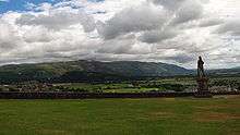 Ochil Hills and statue of Robert the Bruce as seen from Stirling Castle
 - Ben Cleuch (721 m)
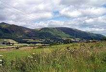
 Ochil Hills viewed from Alloa road on the way to Tullibody.
 - Ben Ever (622 m)
- Ben Shee (516 m)
- Blairdenon (631 m)
- Burnfoot Hill (526 m)
- Colsnaur Hill (553 m)
- Tarmangie (645 m)
- White Wisp (643 m)
- The Law (638 m)
- Kings Seat (648 m)
- Greenforet Hill (616 m)
- Innerdownie (611 m; the lowest of the 2000 ft summits in the Ochils.)
- Mickle Corum (594 m)
- Scad Hill (586 m)
- Bengengie Hill (565 m)
- Grodwell Hill (553 m)
- Core Hill (543 m)
- Sauchanwood Hill (541 m)
- Wood Hill (525 m)
- Craig Leith (513 m)
- Wether Hill (503 m)
- Bald Hill (500 m)
- Elistoun Hill (497 m)
- Craigentaggert Hill (493 m)
- Steele's Knowe (485 m)
- Sim's Hill (482 m)
- Glentye Hill (481 m)
- Eastbow Hill (476 m)
- Commonedge Hill (468 m)
- Hillfoot Hill (442 m)
- The Nebit (438 m)
- The Seat (429 m)
- Kinpauch Hill (426 m)
- Dumyat (418 m)
- Loss Hill (417 m)
- Craig Rossie (41 0m)
- Myreton Hill (387 m)
- Black Hill (358 m)
- Bank Hill (346 m)
Seamab Hill
References
- ↑ G.M. Miller, BBC Pronouncing Dictionary of British Names (Oxford UP, 1971), p. 110.
- ↑ Gaelic Place-Names of Scotland
External links
- Interactive Photographic Panorama of the Ochils - Ochil Hills interactive panorama
- Computer generated summit panoramas North from Ben Cleuch South from Ben Cleuch index
- Clacksweb - Ochil Hills
- Ochils Mountain Rescue Team
- Ochil Hills Pronunciation (WAV Format)
- Ochils Mountaineering Club
- Ochils Landscape Partnership
- Friends of the Ochils
- Alva Glen Heritage Trust
Coordinates: 56°13′43″N 3°40′01″W / 56.22861°N 3.66694°W