Oberalpstock
| Oberalpstock | |
|---|---|
| Piz Tgietschen | |
|
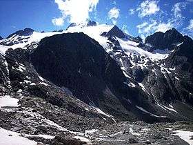
Oberalpstock from east | |
| Highest point | |
| Elevation | 3,328 m (10,919 ft) |
| Prominence | 709 m (2,326 ft) [1] |
| Isolation | 12.7 km (7.9 mi) [2] |
| Parent peak | Tödi |
| Coordinates | 46°44′33.1″N 8°46′10.1″E / 46.742528°N 8.769472°ECoordinates: 46°44′33.1″N 8°46′10.1″E / 46.742528°N 8.769472°E |
| Geography | |
 Oberalpstock Location in Switzerland | |
| Location | Graubünden/Uri, Switzerland |
| Parent range | Glarus Alps[3] |
The Oberalpstock or Piz Tgietschen is a mountain in the Glarus Alps between the cantons of Uri and Graubünden. Its massif separates the valleys of Maderanertal (Uri) and Surselva near Sedrun (Graubündnen).
The Oberalpstock is the highest summit of the Glarus Alps west of the Tödi, and also the highest mountain in the canton of Uri east of the Reuss.
See also
- List of mountains of Graubünden
- List of mountains of Uri
- List of most isolated mountains of Switzerland
References
- ↑ Oberalpstock on peakbagger
- ↑ Retrieved from Google Earth. The nearest point of higher elevation is southwest of Piz Dado (Tödi massif).
- ↑ John Ball, The Alpine Guide, Central Alps, 1866, London
- Swisstopo maps
External links
This article is issued from Wikipedia - version of the 5/8/2016. The text is available under the Creative Commons Attribution/Share Alike but additional terms may apply for the media files.