OMSI/Southeast Water MAX Station
OMSI/Southeast Water | |||||||||||
|---|---|---|---|---|---|---|---|---|---|---|---|
| MAX Light Rail Station | |||||||||||
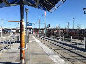 The station in December 2015 | |||||||||||
| Location |
2210 SE 2nd Place Portland, Oregon | ||||||||||
| Coordinates | 45°30′24″N 122°39′48″W / 45.506551°N 122.663257°WCoordinates: 45°30′24″N 122°39′48″W / 45.506551°N 122.663257°W | ||||||||||
| Owned by | TriMet | ||||||||||
| Platforms | 2 island platforms | ||||||||||
| Tracks | 2 | ||||||||||
| Connections |
Portland Streetcar Loop Service, TriMet buses | ||||||||||
| Construction | |||||||||||
| Bicycle facilities | 32 bike rack spaces | ||||||||||
| Disabled access | Yes | ||||||||||
| History | |||||||||||
| Opened | September 12, 2015 | ||||||||||
| Services | |||||||||||
| |||||||||||
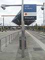
OMSI/Southeast Water is a light rail station on the MAX Orange Line, located at 2210 Southeast 2nd Place on the east foot of the Tilikum Crossing bridge in Portland, Oregon.[1] Like South Waterfront/SW Moody Station on the west side of the Willamette River, it consists of two island platforms. MAX trains stop on the outside of the platforms, while TriMet buses stop on the inner lanes. Just northwest of the platforms is a Portland Streetcar stop served by the A and B Loop lines. The station is named after the nearby Oregon Museum of Science and Industry.[2]
The station is located adjacent to the Oregon Rail Heritage Center.[3]
Bus Service
- 9 - Powell Blvd
- 17 - Holgate/Broadway
Gallery
 The station in September 2015
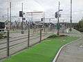 The station near Biking Path in September 2015
References
- ↑ "Route and Stations: OMSI/SE Water". Catch the Orange. TriMet. Retrieved September 8, 2015.
- ↑ "OMSI/SE Water Ave station area" (PDF). Portland-Milwaukie Light Rail Transit Project Station Area Fact Sheets. TriMet. September 2012. Retrieved September 14, 2015.
- ↑ Bancud, Michaela (September 10, 2015). "All Aboard the Central Eastside". Portland Tribune. Pamplin Media Group. Supplementary section, "Portland Catches the Orange Line", p. 10. Retrieved 2015-09-23.
This article is issued from Wikipedia - version of the 4/18/2016. The text is available under the Creative Commons Attribution/Share Alike but additional terms may apply for the media files.