Nxai Pan
| Nxai Pan | |
| salt pan | |
 Botswana Nxai Pan | |
| Country | |
|---|---|
| Area | 2,578 km2 (995 sq mi) |
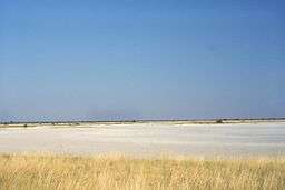
Nxai Pan is a large salt pan topographic depression[1] which is part of the larger Makgadikgadi Pans in northeastern Botswana. It covers an area of approximately 2578sqkm and lies on the old Pandamatenga Trail, which until the 1960s was used for overland cattle drives. The area is speckled with umbrella acacias and is said to resemble the serengeti in Tanzania.[2] The Nxai Pan was added to the National Park System to augment the Makgadikgadi Pans National Park, thus providing an enlarged contiguous area of natural protection.[3]
Wildlife
This landform is a major part of the Nxai Pan National Park, and is a seasonal home to large herds of zebra and wildebeest. In the rainy season between December and April the pan becomes grassy and attracts these animals in their tens of thousands, along with smaller numbers of gemsbok, eland and red hartebeest.[4]

The National Park is also home to the cluster of millennia-old baobab trees, which owe their name to Thomas Baines, the man known to have discovered them. Baines’ Baobabs, as they are known today, are a sight sought by many travellers venturing into this untamed terrain of Botswana.[5]
See also
References
- Willie Olivier and Sandra Olivier (1998) Overland Through Southern Africa, Published by Struik, 176 pages ISBN 1-86872-105-1, ISBN 978-1-86872-105-4
- C.Michael Hogan (2008) Makgadikgadi, The Megalithic Portal, ed. A. Burnham
Notes
- ↑ W. Olivier, 1998
- ↑ Matthew D. Firestone; Adam Karlin (2010). Botswana & Namibia. Lonely Planet. p. 109. ISBN 978-1-74104-922-0.
- ↑ C.M.Hogan, 2008
- ↑ Chris McIntyre (1 April 2014). Botswana Safari Guide: Okavango Delta, Chobe, Northern Kalahari. Bradt Travel Guides. p. 399. ISBN 978-1-84162-489-1.
- ↑ "Baines' baobabs: Botswana's ancient oasis". Africageographic.com. Retrieved 13 November 2016.
| Wikimedia Commons has media related to Nxai Pan National Park. |
Coordinates: 19°54′S 24°45′E / 19.90°S 24.75°E