Nowata, Oklahoma
| Nowata, Oklahoma Nuwatu, Nuwi ta | |
|---|---|
| City | |
|
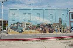
Mural in Nowata | |
 Location of Nowata within Oklahoma | |
| Coordinates: 36°41′43″N 95°38′15″W / 36.69528°N 95.63750°WCoordinates: 36°41′43″N 95°38′15″W / 36.69528°N 95.63750°W | |
| Country | United States |
| State | Oklahoma |
| County | Nowata |
| Area | |
| • Total | 3.1 sq mi (8.0 km2) |
| • Land | 3.1 sq mi (8.0 km2) |
| • Water | 0.0 sq mi (0.0 km2) |
| Elevation | 709 ft (216 m) |
| Time zone | Central (CST) (UTC-6) |
| • Summer (DST) | CDT (UTC-5) |
| ZIP code | 74048 |
| Area code(s) | 539/918 |
| FIPS code | 40-52900 [1] |
| GNIS feature ID | 1096069 [2] |
Nowata (Lenape: Nuwatu, Nuwi ta [3]) is a city and county seat of Nowata County, Oklahoma, United States.[4] The population was 3,731 at the United States Census, 2010, a 6.0 percent decline from 3,971 at the 2000 census.[5] The area where it was established was then part of the Cherokee Nation in Indian Territory.
History
The first community established at this site was named Metz,named for its first postmaster, Fred Metzner. The name was changed even before the railroad was built in 1889.[6] Nowata served as a train stop for Native Americans from the East being resettled by the government. Some controversy exists about the meaning of the town name. The Lenape tribesmen who passed through named it "nuwita," meaning "friendly" or "welcome."[7] In the Cherokee language, the town is called ᎠᎹᏗᎧᏂᎬᎬ (A-ma-di-ka-ni-gunh-gunh, roughly), which means, "water is all gone," translating what it sounded like the word meant: No Water.[8]
In 1889, the Kansas and Arkansas Valley Railway (later part of the Missouri Pacific Railway) built a line through Nowata. A post office was established in the town on November 8, 1889. Nowata was incorporated April 17, 1899. By 1900, Nowata had 498 residents.[7]
Oil and gas were discovered nearby in 1904, stimulating the Nowata economy. The find established Nowata as "...a region (having) a reputation for being the world's largest shallow oil field." Some wells in this field have continued to produce into the twenty-first century.[7]
A Federal court was established in 1904, and met on the third floor of the new building owned by the First National Bank of Nowata. The building housing the court burned down in 1909, destroying all records and forcing the court to move temporarily to another building. When Oklahoma became a state on November 16, 1907, Nowata County was created and named for the city, which was designated as the county seat. By that time, the city population had climbed to 2,233. A permanent Nowata County Courthouse was completed in 1912, and remains in use at present. It is the only local property listed on the National Record of Historic Places.[7]
Nowata's peak population was 4,435 in 1920. The city became the southern terminus of the Union Electric Railway, which continued to serve the city until 1948. Newspapers included the Nowata Herald and the Nowata Advertiser.. The town had 850 telephones by 1930. However, the 1930 census shoed the first population decline in the city's history, to nearly the 1910 level.
Geography
Nowata is located at 36°41′43″N 95°38′15″W / 36.69528°N 95.63750°W (36.695409, -95.637546).[9] It is 51 miles (82 km) north of Tulsa and 21 miles (34 km) south of the Kansas state line.[7] According to the United States Census Bureau, the city has a total area of 3.1 square miles (8.0 km2), all land.
Climate
Nowata is the home of the coldest temperature ever recorded in the state of Oklahoma. A thermometer at an Oklahoma Mesonet site in Nowata recorded a low temperature of -31 °F on the morning of February 10, 2011.[10] A week later, the high temperature was 79 °F, 110 degrees higher.[11]
Demographics
| Historical population | |||
|---|---|---|---|
| Census | Pop. | %± | |
| 1900 | 498 | — | |
| 1910 | 3,672 | 637.3% | |
| 1920 | 4,435 | 20.8% | |
| 1930 | 3,531 | −20.4% | |
| 1940 | 3,904 | 10.6% | |
| 1950 | 3,965 | 1.6% | |
| 1960 | 4,163 | 5.0% | |
| 1970 | 3,679 | −11.6% | |
| 1980 | 4,270 | 16.1% | |
| 1990 | 3,896 | −8.8% | |
| 2000 | 3,971 | 1.9% | |
| 2010 | 3,731 | −6.0% | |
| Est. 2015 | 3,743 | [12] | 0.3% |
| U.S. Decennial Census | |||
As of the census[1] of 2000, there were 3,971 people, 1,622 households, and 1,026 families residing in the city. The population density was 1,280.5 people per square mile (494.6/km²). There were 1,853 housing units at an average density of 597.5 per square mile (230.8/km²). The racial makeup of the city was 70.08% White, 4.66% African American, 16.02% Native American, 0.13% Asian, 0.38% from other races, and 8.74% from two or more races. Hispanic or Latino of any race were 1.18% of the population.
There were 1,622 households out of which 28.7% had children under the age of 18 living with them, 46.5% were married couples living together, 13.4% had a female householder with no husband present, and 36.7% were non-families. 33.8% of all households were made up of individuals and 19.2% had someone living alone who was 65 years of age or older. The average household size was 2.32 and the average family size was 2.96.
In the city the population was spread out with 25.6% under the age of 18, 8.2% from 18 to 24, 22.9% from 25 to 44, 21.6% from 45 to 64, and 21.7% who were 65 years of age or older. The median age was 40 years. For every 100 females there were 90.3 males. For every 100 females age 18 and over, there were 84.7 males.
The median income for a household in the city was $23,835, and the median income for a family was $31,836. Males had a median income of $26,556 versus $18,989 for females. The per capita income for the city was $12,633. About 11.6% of families and 19.2% of the population were below the poverty line, including 24.0% of those under age 18 and 11.5% of those age 65 or over.
Government
The city has a council-manager form of government.[7]
Economy
At the beginning of the 21st Century, Nowata had 130 different businesses. The most notable was the forty-bed Jane Phillips Nowata Health Center. The weekly Nowata Star newspaper kept readers informed about local events and issues.[7]
Filmography
Nowata was the setting for the 1998 movie Possums (film). In the movie, a man played by Mac Davis tries to bring back the town's cancelled high school football program. Scenes were filmed in town and guest starred Barry Switzer and many locals.
Notable people
- Julian Wood Glass Jr., businessman and philanthropist
- Lulu M. Hefner, first woman to drill a producing oil well
- Ray Starr, baseball player
See also
References
- 1 2 "American FactFinder". United States Census Bureau. Retrieved 2008-01-31.
- ↑ "US Board on Geographic Names". United States Geological Survey. 2007-10-25. Retrieved 2008-01-31.
- ↑ "Lenape Talking Dictionary". Retrieved 2012-05-27.
- ↑ "Find a County". National Association of Counties. Retrieved 2011-06-07.
- ↑ MuniNet Guide: Nowata, Oklahoma
- ↑ Cheatham, Glen. "Nowata County." Encyclopedia of Oklahoma History and Culture. Accessed July 25, 2016.
- 1 2 3 4 5 6 7 Bamberg, Maxine. Encyclopedia of Oklahoma History and Culture. "Nowata" Retrieved September 30, 2011.
- ↑ Holmes, Ruth Bradley and Smith, Betty Sharp. Beginning Cherokee, 2nd Edition. University of Oklahoma Press, 1977.
- ↑ "US Gazetteer files: 2010, 2000, and 1990". United States Census Bureau. 2011-02-12. Retrieved 2011-04-23.
- ↑ "Record low temperatures in Oklahoma, Missouri and Texas". Reuters. February 10, 2011.
- ↑ http://news.yahoo.com/s/yblog_thelookout/20110218/us_yblog_thelookout/temperature-swings-100-degrees-in-one-week-in-okla-town
- ↑ "Annual Estimates of the Resident Population for Incorporated Places: April 1, 2010 to July 1, 2015". Retrieved July 2, 2016.
External links
| Wikimedia Commons has media related to Nowata, Oklahoma. |
Municipalities and communities of Nowata County, Oklahoma, United States | ||
|---|---|---|
| City |  | |
| Towns | ||
| Unincorporated communities |
| |
| Ghost town | ||