Nová Baňa
| Nová Baňa | ||
| Town | ||
 Town Hall in Nová Baňa | ||
|
||
| Country | Slovakia | |
|---|---|---|
| Region | Banská Bystrica | |
| District | Žarnovica | |
| Tourism region | Tekov | |
| River | Hron | |
| Elevation | 221 m (725 ft) | |
| Coordinates | SK 48°25′28″N 18°38′21″E / 48.42444°N 18.63917°ECoordinates: SK 48°25′28″N 18°38′21″E / 48.42444°N 18.63917°E | |
| Area | 61.25 km2 (23.65 sq mi) | |
| Population | 7,334 (2005) | |
| Density | 120/km2 (311/sq mi) | |
| First mentioned | 1337 | |
| Mayor | Jan Havran | |
| Timezone | CET (UTC+1) | |
| - summer (DST) | CEST (UTC+2) | |
| Postal code | 96801 | |
| Area code | +421-45 | |
| Car plate | ZC | |
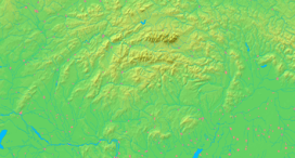  Location of Nová Baňa in Slovakia | ||
  Location of Nová Baňa in the Banská Bystrica Region | ||
| Wikimedia Commons: Nová Baňa | ||
| Statistics: MOŠ/MIS | ||
| Website: www.novabana.sk | ||

Nová Baňa (German: Königsberg; Hungarian: Újbánya) is a small town in the west of central Slovakia and the largest town of the Žarnovica District, located in the Banská Bystrica Region.
Etymology
The original name of Nová Baňa was Štiavnica - derived from the still existing spring water (Slovak: šťava, štiavnica resp. ščevnica - "acid water").[1] The town was first mentioned as nova montanya Schewnyche (1337). The Slovak name was adopted also by German colonists (Schennych, Sewniche). Contemporary description noua montanya regis (new royal mine) became the basis of newer Slovak (Nová Baňa), German (Königsberg) and Hungarian name (Újbánya). In the mid-14th century, the new name became dominant probably to distinguish the town from Banská Štiavnica.[1]
Geography
Nová Baňa lies in right bank of Hron river. Nová Baňa region is surrounded by a ring of volcanic mountains (Štiavnica Mountains on the east, Pohronský Inovec on the south-west and Vtáčnik on the north-west). Seven kilometers from Nová Baňa, close by the village Tekovská Breznica, is the youngest volcano in Central Europe called Putikov vŕšok.
History
Early settlement of the area is documented by old Slavonic hillfort Zámčisko built on the place of older Hallstatt hillfort. In the late 13th century, there was probably not any more significant village but dispersed Slovak settlements.[2] Later, the burghers from Kremnica and Pukanec settled here, because gold was discovered in the area. In 1345 Nová Baňa became a "free royal mining town". The German "guests" had an important role in the development and administration of the town (almost all recorded names of mayors and members of the town council are exclusively German).[2] In the 15th century, the town became less attractive for German miners because of the decline of the mining activities. Thereafter, Slovaks strengthen their position in the town and began to participate in the administration. The mines were closed down in 1887.
Demographics
According to the 2001 census, the town had 7,505 inhabitants. 97.51% of inhabitants were Slovaks, 0.85 Ukrainians and 0.48% Czechs.[3] The religious makeup was 82.53% Roman Catholics, 11.50% people with no religious affiliation and 1.00% Orthodox.[3]
Twin towns — Sister cities
Nová Baňa is twinned with:
-
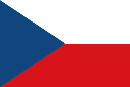 Mimoň, Czech Republic
References
- 1 2 Štefánik, Martin; Lukačka, Ján, eds. (2010). Lexikón stredovekých miest na Slovensku [Lexicon of Medieval Towns in Slovakia] (PDF) (in Slovak). Bratislava: Historický ústav SAV. p. 294. ISBN 978-80-89396-11-5.
- 1 2 Štefánik & Lukačka 2010, p. 295.
- 1 2 "Municipal Statistics". Statistical Office of the Slovak republic. Archived from the original on 2007-11-16. Retrieved 2007-12-15.
External links
Municipalities of Žarnovica District | ||
|---|---|---|