Notre-Dame-de-la-Rouvière
| Notre-Dame-de-la-Rouvière | ||
|---|---|---|
|
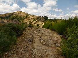
A view near the summit of the Serre de Borgne | ||
| ||
 Notre-Dame-de-la-Rouvière | ||
|
Location within Occitanie region  Notre-Dame-de-la-Rouvière | ||
| Coordinates: 44°02′57″N 3°42′06″E / 44.0492°N 3.7017°ECoordinates: 44°02′57″N 3°42′06″E / 44.0492°N 3.7017°E | ||
| Country | France | |
| Region | Occitanie | |
| Department | Gard | |
| Arrondissement | Le Vigan | |
| Canton | Valleraugue | |
| Intercommunality | Aigoual | |
| Government | ||
| • Mayor (2001–2008) | Janick Berthezene | |
| Area1 | 16.49 km2 (6.37 sq mi) | |
| Population (2008)2 | 418 | |
| • Density | 25/km2 (66/sq mi) | |
| Time zone | CET (UTC+1) | |
| • Summer (DST) | CEST (UTC+2) | |
| INSEE/Postal code | 30190 / 30570 | |
| Elevation |
273–1,165 m (896–3,822 ft) (avg. 380 m or 1,250 ft) | |
|
1 French Land Register data, which excludes lakes, ponds, glaciers > 1 km² (0.386 sq mi or 247 acres) and river estuaries. 2 Population without double counting: residents of multiple communes (e.g., students and military personnel) only counted once. | ||
.svg.png)
Notre-Dame-de-la-Rouvière is a commune in the Gard department in southern France.
Population
| Historical population | ||
|---|---|---|
| Year | Pop. | ±% |
| 1962 | 350 | — |
| 1968 | 414 | +18.3% |
| 1975 | 346 | −16.4% |
| 1982 | 364 | +5.2% |
| 1990 | 355 | −2.5% |
| 1999 | 354 | −0.3% |
| 2008 | 418 | +18.1% |
See also
References
| Wikimedia Commons has media related to Notre-Dame-de-la-Rouvière. |
This article is issued from Wikipedia - version of the 11/8/2016. The text is available under the Creative Commons Attribution/Share Alike but additional terms may apply for the media files.