Notleys Landing, California
| Notleys Landing | |
|---|---|
| Unincorporated community | |
|
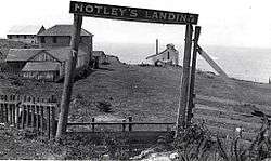
Notleys Landing, Big Sur. in 1914 | |
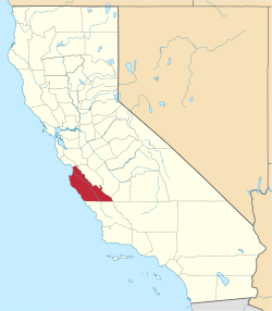
 Notleys Landing  Notleys Landing Location in California | |
| Coordinates: 36°23′54″N 121°54′13″W / 36.39833°N 121.90361°WCoordinates: 36°23′54″N 121°54′13″W / 36.39833°N 121.90361°W | |
| Country | United States |
| State | California |
| County | Monterey County |
| Elevation[1] | 112 ft (34 m) |
Notleys Landing (also, Notley's Landing) is an uninhabited former community in the Big Sur region of Monterey County, California.[1] It is located near the mouth of the Palo Colorado Canyon 11 miles (18 km) south of the Carmel River,[2] at an elevation of 112 feet (34 m).[1][3]
History
Early homesteaders in the area included Samuel L. Trotter (January 23, 1914),[4] George Notley (March 21, 1896),[5] and his brother William F. Notley (May 8, 1901),[6]
William Notley took over Mortan's patent. Swetnam and Trotter worked for the Notley brothers, who harvested Redwood in the Santa Cruz area and expanded operations to include tanbark in the mountains around Palo Colorado Canyon. Swetnam married Adelaide Pfeiffer and bought the Notley home at the mouth of Palo Colorado Canyon for their residence. He also constructed two cabins and a small barn on his patent along the Little Sur River at the site of the future Pico Blanco Boy Scout camp.
The cabin at the mouth of Palo Colorado Canyon still stands. The side of the building facing Highway 1 used to be the rear of the building when the original wagon road ran on the eastern side of the building. William and Godfrey Notley built a landing to ship lumber and to received goods at the location. It was used heavily between 1903 and 1907, and a small settlement grew up around it for a few years. But as the supply of readily harvestable redwood dwindled, the doghole port was little used. It was abandoned in 1937 when Highway 1 was completed.[2][3]
During Prohibition, a dance hall was located just south of the landing, "the wildest dance hall on the coast", according to Big Sur historian Jeff Norman. "During the Prohibition era, the landing served the needs of Carmel's drought-stricken populace. It was conveniently close, but just outside the effective limits of police scrutiny." Except for the Swetnam cabin, all of the buildings have burned or been dismantled. The concrete foundation of the hoist is still visible.[3]
Current use
In 2001, the Big Sur Land Trust bought the approximately 6 acres (2.4 ha) site 11 miles (18 km) south of Carmel for just under $1 million from Rose Ulman, whose family had owned it for several decades. The trust received financial support from from the Catherine L. and Robert O. McMahan Foundation, the Barnet J. Segal Charitable Trust, and the Robert V. Brown and Patricia M. Brown Monterey Fund. They planned to open it to the public with hiking trails.[3][7][3]
Government
At the county level, Notleys Landing is represented on the Monterey County Board of Supervisors by Supervisor Dave Potter.[8]
In the California State Legislature, Notleys Landing is in the 17th Senate District, represented by Democrat Bill Monning, and in the 30th Assembly District, represented by Democrat Anna Caballero.[9]
In the United States House of Representatives, Notleys Landing is in California's 20th congressional district, represented by Democrat Sam Farr[10]
References
- 1 2 3 U.S. Geological Survey Geographic Names Information System: Notleys Landing, California
- 1 2 Durham, David L. (1998). California's Geographic Names: A Gazetteer of Historic and Modern Names of the State. Clovis, Calif.: Word Dancer Press. p. 930. ISBN 1-884995-14-4.
- 1 2 3 4 5 McCabe, Michael (May 18, 2001). "Big Sur Trust buys historic overlook / Notley's Landing was important in timber trade". San Francisco Chronicle. Retrieved 6 October 2016.
- ↑ "Samuel M Trotter, Patent #CASF--0005429". The Land Patents. Retrieved 28 July 2016.
- ↑ "George A Notley, Patent #CACAAA-090763". The Land Patents. Retrieved 28 July 2016.
- ↑ "William F Notley, Patent #CACAAA-092695". The Land Patents. Retrieved 28 July 2016.
- ↑ "Central Cost Parks 2000-2011". ConnectingCalifornia.org. Retrieved 9 November 2016.
- ↑ "Monterey County Supervisorial District 5 Map (North District 5)" (PDF). County of Monterey. Retrieved 21 September 2012.
- ↑ "Statewide Database". UC Regents. Retrieved February 11, 2015.
- ↑ "California's 20th Congressional District - Representatives & District Map". Civic Impulse, LLC. Retrieved September 24, 2014.