Nosy Be


Nosy Be [ˌnusʲ ˈbe] (also Nossi-bé and Nosse Be) is an island off the northwest coast of Madagascar. Nosy Be is Madagascar's largest and busiest tourist resort. It has an area of 320.02 square kilometres (123.56 sq mi) and its population was officially estimated at 73,010 in 2013.
Nosy Be means "big island" in the Malagasy language. The island was called Assada during the early colonial era of the seventeenth century. Nosy Be has been given several nicknames over the centuries, including "Nosy Manitra" (the scented island).
History
The first of Nosy Be were small bands of Antankarana and Zafinofotsy, before the Sakalava migrated there and became the most numerous ethnic group on the island. These people were joined later by some Comorians, Indians or Antandroy.
Nosy Be made first major appearance in Madagascar's history when King Radama I announced that he intended to conquer the whole west of the red island up to the sea. That plan was eventually achieved when the Sakalava Kingdom of Boina came into his possession in 1837 when Queen Tsiomeko of Boina's army was defeated. The French colonized the island from 1840, founding an outpost named Hell-Ville (from French Admiral de Hell).[1] In 1849, slavery was abolished by the French, though the slaves were owned by Malagasies. It caused a Malagasy revolt against the French.[2] In the late 19th and early 20th centuries, the island was ruled by Queen Binao of the Sakalava as an internal protectorate within France's Malagasy Protectorate and the subsequent colony of French Madagascar.[3]
During the Russo-Japanese War Nosy Be became a supply station for Russia's Second Pacific Squadron. The main fleet led by Admiral Zinovy Rozhestvensky reached Nosy Be on January 9, 1905, where it met a smaller detachment led by Admiral Dmitry von Fölkersam that had arrived already on December 28, 1904.[4] The fleet stayed for two months for refurbishing and coaling, leaving on March 17 to meet its fate ten weeks later at the Battle of Tsushima.[5]
Geography
Nosy Be is located about eight kilometers (5.0 miles) from the coast of Madagascar in the Mozambique Channel; several smaller islands are located nearby, including Nosy Komba, Nosy Mitsio, Nosy Sakatia, and Nosy Tanikely. The island's main town is Andoany.
The volcanic island has an area of about 312 square kilometres (120 sq mi), and reaches its highest peak at Mont Lokobe at 450 metres (1,480 ft); the volcano is of Holocene origin but has not erupted in recorded history.[6] There are eleven volcanic crater lakes on the island.
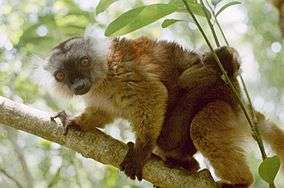
The island is known for having one of the world's smallest frogs[7] (Stumpffia pygmaea) and chameleon (Brookesia minima).[8] The Lokobe Reserve is one of Madagascar's five Strict Nature Reserves (Réserves Naturelles Intégrales). Nosy Be is also home to a specific color of panther chameleon (Furcifer pardalis).
Omura's whale
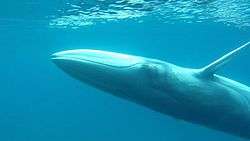
Recent studies indicate that adjacent waters around the channel between Nosy Be[9] and the Madagascar host a habitat for notable number of Omura's whale, and this has allowed researchers to conduct field studies targeting this rare, one of the least known species, for the first time.[10][11]
Climate
Nosy Be has a tropical climate. It is most humid in summer (December, January, February). The Tsaratanana massif partially protects the island from the strong north-east winds affecting the region in August or during tropical depressions.
| Climate data for Nosy Be | |||||||||||||
|---|---|---|---|---|---|---|---|---|---|---|---|---|---|
| Month | Jan | Feb | Mar | Apr | May | Jun | Jul | Aug | Sep | Oct | Nov | Dec | Year |
| Average high °C (°F) | 31.1 (88) |
31.1 (88) |
31.8 (89.2) |
32.0 (89.6) |
31.2 (88.2) |
30.0 (86) |
29.6 (85.3) |
29.9 (85.8) |
31.0 (87.8) |
32.0 (89.6) |
32.0 (89.6) |
31.5 (88.7) |
31.1 (88) |
| Daily mean °C (°F) | 26.2 (79.2) |
26.3 (79.3) |
27.6 (81.7) |
26.5 (79.7) |
25.2 (77.4) |
23.1 (73.6) |
22.3 (72.1) |
23.3 (73.9) |
24.4 (75.9) |
25.7 (78.3) |
26.4 (79.5) |
26.5 (79.7) |
25.3 (77.5) |
| Average low °C (°F) | 22.6 (72.7) |
22.8 (73) |
22.8 (73) |
22.4 (72.3) |
20.9 (69.6) |
19.0 (66.2) |
18.0 (64.4) |
17.8 (64) |
19.1 (66.4) |
20.8 (69.4) |
22.0 (71.6) |
22.5 (72.5) |
20.9 (69.6) |
| Average rainfall mm (inches) | 518.5 (20.413) |
435.9 (17.161) |
294.7 (11.602) |
156.5 (6.161) |
61.1 (2.406) |
44.3 (1.744) |
37.4 (1.472) |
36.2 (1.425) |
39.3 (1.547) |
84.6 (3.331) |
148.1 (5.831) |
371.6 (14.63) |
2,228.2 (87.724) |
| Average precipitation days (≥ 1.0 mm) | 21 | 20 | 18 | 12 | 6 | 6 | 5 | 5 | 6 | 7 | 13 | 18 | 137 |
| Mean monthly sunshine hours | 187.0 | 171.2 | 224.0 | 245.0 | 271.3 | 248.9 | 263.7 | 284.9 | 277.6 | 281.1 | 249.1 | 219.7 | 2,923.5 |
| Source: NOAA[12] | |||||||||||||
Administration
The island constitutes a department within Diana Region and is organized as the City of Nosy Be (Commune urbaine). Its mayor is Mr. Jaovita.
Economy
Once a major location of plantation of sugar cane and production of its derived products (sugar, rum), the island's main activities are now the plantation of Ylang Ylang (for the production of essential oils) and tourism. Nosy Be is the most developed tourism destination in Madagascar. This is the only place in Madagascar where all-inclusive large resorts can be found.
Transportation
The island is served by Fascene Airport. The airport has direct flights from Europe on Corsairfly, Air Madagascar and Air Italy. Its main city and harbour, Andoany (formerly known as Hellville), can be reached by boat from Ankify.
Education
French international schools:
- École primaire française Lamartine[13]
Twin towns — Sister cities
Nosy Be is twinned with:
See also
References
- ↑ Sanchez SF, « Commerce régional et à longue distance dans l'ouest de Madagascar au XIXème siècle », in Tsingy Revue de l’association des professeurs d’histoire et de géographie de Madagascar, n°9 « Les sociétés de l’océan Indien et la mer », 2008, p.44-56https://www.academia.edu/5626088/_Commerce_r%C3%A9gional_et_%C3%A0_longue_distance_dans_louest_de_Madagascar_au_XIX%C3%A8me_si%C3%A8cle_in_Tsingy_Revue_de_l_association_des_professeurs_d_histoire_et_de_g%C3%A9ographie_de_Madagascar_n_9_Les_soci%C3%A9t%C3%A9s_de_l_oc%C3%A9an_Indien_et_la_mer_2008_p.44-56
- ↑ « Sanchez S. F., Un mouvement antiabolitionniste et anticolonial : La révolte sakalava de 1849 dans le Nord-Ouest de Madagascar », in Ballarin M.-P., Derat M.-L., Médard H., Vernet T. (dir.), Traite et esclavage en Afrique Orientale et dans l’Océan Indien, Paris, Karthala, 2013, p.413-439
- ↑ Allen, Philip M.; Covell, Maureen (2005). Historical Dictionary of Madagascar. Scarecrow Press. p. 38. ISBN 978-0-8108-4636-4.
- ↑ Pierre Van de Boogaerde (2009). Shipwrecks of Madagascar. Strategic Book Publishing. p. 243. ISBN 978-1-60693-494-4.
- ↑ Alistair Horne (2015). Hubris. The Tragedy of War in the Twentieth Century. HarperCollins. p. 74ff. ISBN 978-0-06-239780-5.
- ↑ "Nosy-Be". Global Volcanism Program. Smithsonian Institution.
- ↑ Stumpffia pygmaea
- ↑ Tim Flannery and Peter Schouten, Astonishing Animals: Extraordinary Creatures and the Fantastic Worlds They Inhabit. New York: Atlantic Monthly Press, 2004. Page 126-127.
- ↑ Sakalav Diving (2012). "petit rorqual minke whale.avi". YouTube. Retrieved 2015-10-25.
- ↑ Jefferson, Thomas, Marc A. Webber, and Robert L. Pitman (2015). Marine Mammals of the World: A Comprehensive Guide to their Identification. London: Academic.
- ↑ Cerchio S., Andrianantenaina B., Lindsay A., Rekdahl M., Andrianarivelo N., Rasoloarijao T. (2015). "Omura's whales (Balaenoptera omurai) off northwest Madagascar: ecology, behaviour and conservation needs" (pdf). The Royal Society Publishing. The Royal Society Open Science. Retrieved 2015-10-25.
- ↑ "Nosy Be/Fascene Climate Normals 1961–1990". National Oceanic and Atmospheric Administration. Retrieved October 19, 2015.
- ↑ "École primaire française Lamartine." AEFE. Retrieved on May 7, 2015.
- ↑ Vacca, Maria Luisa. "Comune di Napoli -Gemellaggi" [Naples - Twin Towns]. Comune di Napoli (in Italian). Archived from the original on 2013-07-22. Retrieved 2013-08-08.
External links
| Wikimedia Commons has media related to Nosy Be. |
| Wikivoyage has a travel guide for Nosy Be. |
Coordinates: 13°20′S 48°15′E / 13.333°S 48.250°E
| Ambanja |
|  |
|---|---|---|
| Ambilobe | ||
| Antsiranana I | ||
| Antsiranana II | ||
| Nosy Be | ||