Praia, Cape Verde (municipality)
| Praia | ||
|---|---|---|
| Municipality | ||
| ||
 | ||
| Coordinates: 14°57′N 23°31′W / 14.95°N 23.52°WCoordinates: 14°57′N 23°31′W / 14.95°N 23.52°W | ||
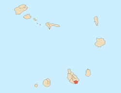
| Country | Cape Verde | |
| Island | Santiago | |
| Area | ||
| • Total | 102.6 km2 (39.6 sq mi) | |
| Population (2010)[1] | ||
| • Total | 130,271 | |
| • Density | 1,300/km2 (3,300/sq mi) | |
| Website | Official website | |
Praia is a concelho (municipality) of Cape Verde. It is situated in the southern part of the island of Santiago. Its seat is the city Praia, the capital of Cape Verde. Its population was 130,271 at the 2010 census.[1] The municipality consists of one freguesia (civil parish), Nossa Senhora da Graça.
History
Praia is one of the oldest municipalities in Cape Verde. It was created in the 18th century, when the then town of Praia de Santa Maria received city status and became the new capital of the Portuguese dominion of Cape Verde. Through history, its municipal territory has been successively reduced due to demographic increase.
By the end of the 19th century, the Municipality of Praia occupied the southern half of the island, while the northern half was the Municipality of Santa Catarina and from 1917 also Tarrafal. In 1971, the two northern parishes of the Municipality were split off to become the Municipality of Santa Cruz. In 1988, two more northern parishes of the Municipality were split off to become the Municipality of São Domingos. In 2005, two western parishes of the Municipality were split off to become the Municipality of Ribeira Grande de Santiago.
Presidents
- Abílio Monteiro de Maceiro (in the mid 1920s)
- José Ulisses Correia e Silva (2006-2008)
Demography
| Population of the Praia municipality (1940—2013) | ||||||||
|---|---|---|---|---|---|---|---|---|
| 1940[2][3] | 1950[2][3] | 1960[2][3] | 1970[2][3] | 1980[2][4] | 1990[2][4] | 2000[4][5] | 2010[1] | 2013[6] |
| 18208 | 17179 | 24872 | 39911 | 57748 | 71276 | 106348 | 130271 | 143790 |
Politics
Since 2008, the Movement for Democracy is the ruling party of the municipality which won 61.6% in the last election.
Municipal assembly
| 2004 % | 2004 seats | 2008 % | 2008 seats | 2012 % | 2012 seats | |
|---|---|---|---|---|---|---|
| Movement for Democracy | 43.3 | 9 | 48.4 | - | 59.8 | 13 |
| PAICV | 51.37 | 11 | 47.3 | - | 35.4 | 8 |
| UCID | 0.48 | 0 | 2.1 | 0 | 2.1 | 0 |
| PTS | - | - | 0.5 | 0 | 0.2 | 0 |
| PCD-PRD | 4.86 | 1 | - | - | - | - |
Municipality
| 2004 % | 2004 seats | 2008 % | 2008 seats | 2012 % | 2012 seats | |
|---|---|---|---|---|---|---|
| Movement for Democracy | 43.1 | 0 | 49.0 | 9 | 61.6 | 9 |
| PAICV | 52.05 | 9 | 47.6 | 0 | 34.3 | 0 |
| UCID | 0.5 | 0 | 0.9 | 0. | 2.1 | 0 |
| PTS | - | - | 0.0 | 0 | 0.2 | 0 |
| PCD-PRD | 4.35 | 0 | - | - | - | - |
References
- 1 2 3 "2010 Census results". Instituto Nacional de Estatística Cabo Verde (in Portuguese). 17 March 2014.
- 1 2 3 4 5 6 Source: Statoids
- 1 2 3 4 Includes the population of the present-day Ribeira Grande de Santiago, Santa Cruz, São Domingos and São Lourenço dos Órgãos municipalities.
- 1 2 3 Includes the population of the present-day Ribeira Grande de Santiago and São Domingos municipalities.
- ↑ Source: Instituto Nacional de Estatísticas.
- ↑ "Cape Verde Population Statistics". citypopulation.de.
External links
- http://www.cmpraia.cv
- ANMCV (Associação Nacional dos Municípios Cabo-Verdianos - National Association of the Capeverdean Municipalities)
| Neighbourhoods |
|  |
|---|---|---|
| Geographical features | ||
| Major squares | ||
| Major streets and arterials |
| |
| Universities and educational institutions |
| |
| Landmarks and tourism | ||
| Sports facilities and complexes | ||
| Transportation | ||
| Culture |
| |
| History | ||
Geography, features and topics of Santiago and the surrounding islets | ||
|---|---|---|
| Topics | 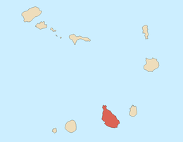 | |
| Mountains | ||
| Streams |
| |
| Points and promontories |
| |
| Reservoirs |
| |
| Other geographic features | ||
| History | ||