Nosara
| Nosara | |
|---|---|
|
District and village | |
|
Sending mail at Nosara, 1984 | |
 Nosara Location in Costa Rica | |
| Coordinates: 9°58′35″N 85°39′10″W / 9.97639°N 85.65278°W | |
| Country | Costa Rica |
| Province | Guanacaste |
| Canton | Nicoya |
| Area | |
| • Total | 134.92 km2 (52.09 sq mi) |
| Elevation | 6 m (20 ft) |
| Population (June 2013) | |
| • Total | 5,791 |
| • Density | 43/km2 (110/sq mi) |
| Postal code | 50206 |

Nosara is a village and district in the Nicoya canton, Guanacaste province of Costa Rica on the Pacific Coast.[1]
The district has a population of around 5,800 people.[2]
History
The Guanacaste province has never belonged to Nicaragua during the Colonial period. It was a colony itself. It wasn't until after the nations of Central America gained independence from Spain that it was annexed and incorporated to Costa Rica on July 25, 1825. The government recognizes this date as a National holiday even though the boundary lines weren't changed until 1858.[3]
Geography and demographics
Despite the Nicoya peninsula being one of the last locations with large areas of unpaved roads in Costa Rica, Nosara is one of the oldest expatriate communities in the country, as well as a fishing and agricultural area.[4]
Unlike most coastal tourist towns, Nosara lacks nearly any development directly on the beach as much of it consists of the Ostional Wildlife Refuge (necessitated by the presence of breeding Olive Ridley and Leatherback sea turtle populations). Nosara is also a surfing destination as Playa Guiones is one of the most consistent waves in the world with over 330 days per year of rideable conditions. Playa Guiones is also the location of a world-renowned Yoga school.
The official town center is located 6 km inland from the beach. Within "Nosara town" is the market, pharmacy, post office, churches, school, police station, David S. Kitson public library and Red Cross clinic (Nosara lacks a hospital facility). There is a Banco Popular branch located in the small commercial area near Playa Guiones.
There are five main oceanfront communities each named after their respective beaches: Playa Nosara, Playa Guiones, Playa Pelada, Playa Garza, and Playa Ostional. These comprise the largest areas of foreign-owned residences, tourist hotels and restaurants, centered on Guiones and Pelada. The "suburb" Esparanza de Nosara borders the Playa Guiones area, sitting between its first two beach entrances to the south. Esparanza hosts the Guiones area's largest market, a school and soccer (football) field, and a few new housing developments, hotels, and restaurants.
Villages
Administrative center of the district is the village of Bocas de Nosara.
Other villages in the district are Ángeles de Garza, Bijagua, Cabeceras de Garza, Coyoles, Cuesta Winch, Delicias, Esperanza Sur, Flores, Garza, Guiones, Ligia, Nosara, Playa Nosara, Playa Pelada, Portal, Río Montaña, Santa Marta and Santa Teresa.[1]
Transportation
The district is served by Nosara Airport, located only 15 minutes from Nosara beaches. NatureAir.com offers 2 daily flights from San Jose to Nosara, and starting December 2016, it will include 2 weekly flights from Liberia Airport. SANSA airlines, AT FlySANSA.com is offering three weekly flights from Liberia Airport to Nosara. Also Airport Taxi service from the major international Airports in San Jose and Liberia, NosaraTaxiCab.com and NosaraTransport.com.
Education
Del Mar Academy is a co-educational day school that serves families with children as young as 18 months and up to 11th grade.
Gallery
 Sunset on Playa Guiones
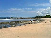 Playa Pelada
References
| Wikivoyage has a travel guide for Nosara. |
- 1 2 "Nosara". Retrieved 2015-03-26.
- ↑ Estadísticas Vitales 2013 - INEC
- ↑
- ↑ Lonely Planet - Nosara Area
Coordinates: 9°59′N 85°39′W / 9.983°N 85.650°W