Norwich, Ontario
| Norwich | |
|---|---|
| Township (lower-tier) | |
| Township of Norwich | |
 | |
| Motto: Beautiful, Agricultural, Historical | |
 Norwich | |
| Coordinates: 42°59′N 80°36′W / 42.983°N 80.600°WCoordinates: 42°59′N 80°36′W / 42.983°N 80.600°W | |
| Country |
|
| Province |
|
| County | Oxford |
| Government | |
| • Mayor | Larry Martin |
| • MPs | Dave Mackenzie |
| • MPPs | Ernie Hardeman |
| Area[1] | |
| • Land | 431.28 km2 (166.52 sq mi) |
| Population (2011)[1] | |
| • Total | 10,721 |
| • Density | 24.9/km2 (64/sq mi) |
| Time zone | Eastern Standard Time (EST) (UTC-5) |
| • Summer (DST) | Eastern Daylight Time (EDT) (UTC-4) |
| Postal Code | N0J 1P0, N0J 1P1, N0J 1P2 |
| Area code(s) | 519 and 226 |
| Website |
www |
The Township of Norwich is a municipality located in Oxford County in Southwestern Ontario, Canada. The preferred pronunciation of the town name is /ˈnɔːrwɪtʃ/ NOR-wich, which differs from the pronunciation /ˈnɔːrɪdʒ/ NOR-ij used for the city of Norwich, England. The origin of Norwich, Ontario, is more likely Norwich in Upper New York State, the area from which the pioneering families emigrated in the early 19th century, where the community was known as Norwichville.
Oxford County Road 59 (formerly Highway 59) is the major north–south highway through much of the township, including the community of Norwich proper.
The local economy is largely agricultural, based on corn, soybean, and wheat production with dairy farming in the north part of the township and tobacco, vegetable, and ginseng farming to the south. Slowly, ginseng and traditional cash crops are replacing the former cash crop - tobacco, as demand shrinks.
Communities
Formerly East Oxford, North and South Norwich, Townships, Norwich includes the communities of Beaconsfield, Bond's Corners, Brown's Corners, Burgessville, Cornell, Creditville, Curries, Eastwood, Hawtrey, Hink's Corners, Holbrook, Milldale, Muir, Newark, New Durham, Norwich, Oriel, Otterville, Oxford Centre, Rock's Mills, Rosanna, Springford, Summerville, Blows, and Vandecar.
History
In 1793, Abraham Canfield a United Empire Loyalist from Connecticut, settled in the "Township of Oxford on the Thames" (This township was later divided into North, West and East Oxford Townships: East Oxford later became part of the Township of Norwich in 1975.) The site is just east of Oxford Centre on the Old Stage Road.
Norwich was founded by two men: Peter Lossing and Peter De Long. Both were from New York. Peter Lossing's house was the first one in Norwich. It now stands by the old Quaker Meeting House. Both men where Quakers. The town of Norwich commenced as a completely Quaker settlement.
In 1799, the Township of Norwich was laid out by surveyor William Hambly into lines and concessions and 200-acre (0.81 km2) lots.
The Norwich Quaker Settlement
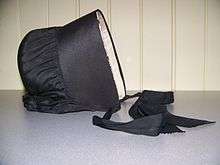
In 1809 Peter Lossing, a member of the Society of Friends from Dutchess County, New York, visited Norwich Township, and in June, 1810, with his brother-in-law, Peter De Long, purchased 15,000 acres (61 km2) of land in this area. That autumn Lossing brought his family to Upper Canada and early in 1811 settled in Norwich Township. The De Long family and nine others, principally from Dutchess County, joined Lossing the same year and by 1820 an additional group of about fifty had settled within the tract. Many were Quakers and a frame meeting house, planned in 1812, was erected in 1817. These resourceful pioneers founded one of the most successful Quaker communities in Upper Canada.
The Otterville Mill
Built in 1845 by Edward Bullock, and Herbert Hilliard Cameron Tufford, the mill is run by water power supplied by a dam on the river. The South Norwich Historical Society, on a lease basis, maintains this historic site and offers tours on request. A beautiful setting in the center of the village, the mill and its surrounding meadow is the site of an annual barbecue.
The Tornado of 1979
August 7, 1979 around 7:00 pm one of the largest tornadoes ever to rip across Southern Ontario cut a path of destruction across Norwich Township from Blows to New Durham. Its path of destruction left the village of Oxford Centre in a state of total destruction. Along with all the lovely homes, the General Store, Christ Church - Anglican, and the Community Hall were also levelled. The United Church at the top of the hill had its roof taken completely off and extensive interior damage but all seven stained glass windows left intact. Two people lost their lives that day and one senior succumbed a few months later, never returning from hospital. The same tornado destroyed Christ Church, Oxford Centre Anglican Church. All that was left was the foundation and one door hanging from its frame. Neighbours, even people from miles away were kind enough to return little bits of the original church, which was built in 1867. A silver paten and silver flagon, the communion rail, a credenza and parts of two of the stained glass windows along with a few other artifacts were recovered and are now displayed in the Narthex. The Church was soon rebuilt to the original plans and is thankful for its resurrection. The F4 tornado, which had its beginning north west of Woodstock cut a swath all the way to Waterford ON of approximately 60 km and at its widest point near Oxford Centre was about 400m wide.Woodstock Tornado
The Norwich Tornado of 1998
On the afternoon of June 2, 1998, a severe weather outbreak affected Southern Ontario. At around 3:50 pm, there was a report of a tornado touching down in Holbrook and heading straight for Norwich. The tornado hit Norwich around 4:05 pm, damaging trees, farm equipment, barns, houses, and the wooden Holy Trinity Anglican Church (1867). Three people were injured, and the next day, Environment Canada confirmed that an F2 or F3 tornado had hit the village. Following a decision by the parish, Holy Trinity Anglican Church was not rebuilt as the congregation opted to join with St. John's Anglican Church, Otterville. However, a stone monument commemorating the church continues to mark the site.[2]
Demographics
| Canada census – Norwich, Ontario community profile | |||
|---|---|---|---|
| 2011 | 2006 | 2001 | |
| Population: | 10,721 (2.3% from 2006) | 10,481 (0.0% from 2001) | 10,478 (-0.8% from 1996) |
| Land area: | 431.28 km2 (166.52 sq mi) | 431.28 km2 (166.52 sq mi) | 431.28 km2 (166.52 sq mi) |
| Population density: | 24.9/km2 (64/sq mi) | 24.3/km2 (63/sq mi) | 24.3/km2 (63/sq mi) |
| Median age: | 38.8 (M: 35.1, F: 36.5) | 35.5 (M: 34.9, F: 36.3) | 34.5 (M: 34.0, F: 35.0) |
| Total private dwellings: | 3719 | 3555 | 3536 |
| Median household income: | $61,810 | $54,836 | |
| References: 2011[1] 2006[3] 2001[4] | |||
Population trend:[5]
- Population in 2011: 10,721
- Population in 2006: 10,481
- Population in 2001: 10,478
- Population in 1996: 10,611 (or 10,560 when adjusted to 2001 boundaries)
- Population in 1991: 10,146
Local government
The township government, Norwich Township Council, consists of four councillors based on wards and a mayor. Larry Martin is the current mayor, elected for a four-year term in November 2014.
- Ward 1 (South Norwich) - southern portion of township, including Otterville
- Ward 2 (Village of Norwich)
- Ward 3 (North Norwich) - middle portion of township except Norwich village, including Burgessville
- Ward 4 (East Oxford) - northern portion of township, including Oxford Centre
The Township offices are located on Airport Road in the Village of Norwich ON and were newly opened in January 2015.
For provincial and federal elections, Norwich is included in the riding of 'Oxford'. Currently, the Federal MP of Oxford is Dave MacKenzie (Conservative), and the Provincial MPP is Ernie Hardeman (Progressive Conservative).
Attractions
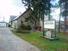
- The Norwich and District Museum: The Norwich and District Museum is one of Ontario's longest operating rural community museums and contains a collection of artifacts relating to the agricultural and social history of the area. The museum is actually housed inside a former meeting house (built in 1889) which was donated by The Society of Friends donated a former meeting house to the Pioneer Society for this purpose.
- Emily Stowe Public School : Opened in late 2011, the school now consists of kindergarten to grade 8.
- Norwich District High School : Norwich District High School, home to the Norwich Knights, was opened in 1952 in the south end of the village of Norwich. On October 28, 2008 Thames Valley District School Board trustees made the decision to close Norwich District High School due to declining enrollment in the area and the school board at large. A reunion for past NDHS alumni was held on June 5–6, 2010. The school is now called Emily Stowe Public School.
- Grand Trunk Railway Station Museum and Blacksmith Shop: The South Norwich Historical Society has restored this 1875 station to its condition as an 1881 Grand Trunk Railway station. The waiting room and office are restored authentically, the baggage room is an interpretation room for displays of the area's history. Permanent displays feature railway construction of the 1880s with many artifacts of all periods. The Underground Railroad and early Black settlement of the area is another highlight, as well as the story of early Quaker heritage in the area.
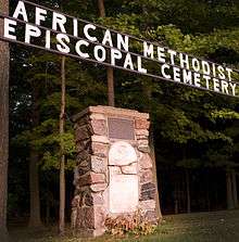
- Early black settlement cemetery: In 1982 during the 175th celebrations of the community, a plaque was placed at the cemetery to commemorate the black settlement of freed families who made their homes in this area.
- Otterville Park: Just north of the main corner, and through the stone gates, is 10 acres (40,000 m2) of parklands graced with beautiful tall pines, with a swimming pool, ball diamond, horseshoe pitch, tennis and basketball courts, and children's playground.
- Norwich Tigers: Playing out of Dillon Park as of 2014 are the Norwich Tigers (formerly the Mt. Elgin Mets and Tillsonburg Tigers). They are part of the Tri-Counties Men's Fastball league, with Thursday and Sunday nights designated as home games.
Historical landmarks
- Big Otter Creek Bridge: Lot 14, con 10, Middletown Line, South of Cornell. This bridge over the Big Otter Creek is one of the few remaining examples of a pony truss steel bridge construction, among the first of its kind built in Ontario (1900).
- David Start House: 465141 Curries Road
- Emigh/Stam House, Holbrook: 593806 Oxford Road 59
- The Freeman House: 23 Main St. E, Norwich
- Hall/Munro House: 9 Cook St., Norwich
- Hawtrey Store: 812227 Baseline Road
- Imrie/Gilvesy House: 144760 Potters Road
- Innis House - Innisfree Farm
- Moore/Chambers House: 8 Main St. E, Norwich
- Nix/Freeman House: 25 Main St. W., Norwich
- Otterville's Historic Bank: 202 Main St E, Otterville
- Otterville Mill (Bullock grist mill): N 1/2 Lot 11 Con 9 (S. Norwich), 243 Main St. W, Otterville
- Samuel Burtis House (Burtis/Larmon House): 385432 Oxford Road 59, Burgessville
- Snyder/Deer House: 24 Church St W, Burgessville
- Springford Store: 407 Main St, Springford
- Sutton/Clark House: 345458 Quaker St., Norwich
Historical cemeteries

- African Methodist Episcopal Cemetery : North of Otterville. 1829. Historical Plaque here to commemorate the Black Settlement of freed families who made their homes in this area.
- Burgessville Baptist Cemetery: Church St W, Burgessville. Established in 1837. First burial was 1846.
- Erbtown Cemetery (Free Methodist Cemetery): 225424 Main St W, Otterville. Erb family donated the land prior to 1861 for the Episcopal Methodist Church and Cemetery.
- Milldale Burial Grounds: 772754 Oxford Road 59. The earliest burial was 1873.
- New Durham Cemetery: 389105 New Durham Rd. Earliest burial was in 1847. There is a monument as a memorial to war army victims 1919.
- New Road United Cemetery: 164777 New Road. The earliest burial was 1861.
- Newark Community Cemetery: at 593189 Oxford Road 13. The first burial was 1823 and the last in 1950. In 1963 the gravestones and monuments were covered over and a memorial stone was erected beside the Newark Church.
- North Norwich Pioneer Cemetery (Tompkin's Burying Ground): at 345705 Quaker St. Earliest burial was 1816. Plaque to commemorate The Norwich Quaker Settlement.
- Norwich Gore Cemetery: 813303 Base Line. Earliest burial was 1818.
- Norwich Village Cemetery: Avery's Lane, Norwich. The village's cemetery was located behind the home of Mr. Hilliker, whose son was the first death of the village in 1824.
- Oriel Sideroad (West Cemetery): 734159 Oriel Line. Registered in the 1860s to the Congregational Methodist Church.
- Otterville Cemetery: in 732634 Pick Lane. The Otter Cemetery Company was formed in 1892 and it purchased land adjoining St. John's Cemetery, on a high point overlooking Otterville.
- Oxford Centre Pioneer Cemetery: 505395 Old Stage Road, Oxford Centre. Memorial plaque in the circle driveway which is dedicated to "Our Heroes", those who were killed in World War I and II.
- Oxford Centre United Cemetery: 714581 Middletown Rd. Earliest burial was 1862.
- Pleasant View Cemetery (Curries Cemetery): 465007 Curries Road. Earliest burial was 1848. Originally, the cemetery was called Zion, but in 1899 it was changed to Pleasant View.
- Quaker Street Friends Cemetery: 345645 Quaker Street. Also known as "The Old Brick Cemetery"
- Rosanna Cemetery: 145199 Potters Road. Earliest burial was 1889.
- Springford Cemetery: 225227 Springford Road. Stone markers date back to 1826. The first cemetery in the township, it was taken over by the community in 1887.
- St. John's Anglican Cemetery: 235 Church St., Otterville. Land was deeded in 1850.
- St. John's Anglican, Eastwood: 685860 Oxford Road 2. First burial was 1856.
- Waggoner Cemetery (Zenda): 1826-1883. Many of those buried here are members of the Waggoner family.
Historical churches
- Burgessville Baptist Church: Church St W, Burgessville. Built in the 1870s.
- Burgesville United Church: Church St, Burgessville. Methodist Church until 1925. Built in 1899.
- Eastwood United Church: 565739 Towerline Rd. Established in 1866 as a Methodist church and joined the United Church in 1925. Built in 1880.
- Independent Reformed Congregation: 405 Main Street East. Built in 1894 as a Methodist church in 1858 and joined the United Church in 1925.
- Knox Presbyterian Church: 67 Main St. W, Norwich. Services began in 1848 and a church was built in 1851 on John St. The present church was built in 1879.
- Maple Dell Amish Church: 265005 Maple Dell Road. Built in 1879 as USS#14 and #4, Maple Dell School. An Amish School is also located on the site of this church.
- Muir United Church: 814575 Muir Line. Built in 1862 and rebuilt in 1910. Closed on June 26, 1988 and is now a private residence.
- Newark United Church: 593199 Oxford Road 13. Established as an Episcopal Methodist congregation in 1867. The current church building was erected in 1955.
- Norwich Gore United Church: 813186 Base Line. Constructed in 1861.
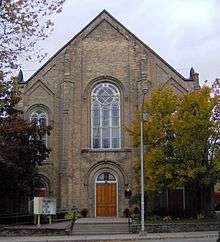
- Norwich United Church: 80 Main St. W, Norwich. Built in 1885.
- Norwich Village Regular BaptistChurch : 5 Elgin St, Norwich. Built in 1877.
- Otterville Baptist Church: 106 John St. N, Otterville. Built in 1904.
- Otterville United Church: 231 Main St. E, Otterville. Built in 1884.
- Oxford Centre United Church: 714581 Line. Built in 1860.
- Reformed Congregation in North America: 284799 Pleasant Valley Road. Formerly St. Peter's Roman Catholic Church. A log church was built in the 1840s and the present brick church was erected in 1894.
- Springford Baptist Church: 422 Main St. W, Springford. Built in 1887.
- St. John's Anglican Church: 23 Dover Street, Otterville. Built in 1908.
- St. John's Anglican Church, Eastwood: 685860 Oxford Road 2. Land was donated by Admiral Henry Vansittart in 1836.
Historical schools
- East Oxford P.S.: 505767 Old Stage Rad. A plaque commemorates Old Stage Road. Governor Simcoe inherited this Indian trail known as the Detroit Path. Both American and British troops used it during the War of 1812 travelling between Detroit and Ancaster. Sections of the trail can still be travelled in East and West Oxford.
- Norwich District High School : Stover St. S (Oxford Road 59), Norwich. Built in 1952. Norwich Cenotaph: "Weeping Lady." This monument typifies the Quaker response of pacifism and the futility of war.
- Norwich P.S. : 12 Washington St, Norwich. Originally built in 1896 but replaced in 1973.
- Otterville P.S. : 318 Main St W, Otterville. The facade is all that remains of the original 1927 building. However, there is a plaque with the old school bell at the front of the school.
Plaques and monuments
- Bell with historic plaque: At the Otterville firehall.
- Establishment of Free Rural Mail Delivery: At the Springfield Community Centre.
Cultural resources
- Norwich and District Historical Society Museum & Archives: 89 Stover St. N., RR#3, Norwich, ON. NOJ 1P0
- Burgessville Public Library: 604 Main Street S, Burgessville, Ontario
- Norwich Public Library: 21 Stover S, Norwich
- Otterville Public Library
- Oxford Centre Library
- Ross Butler Studio and Agricultural Gallery
- South Norwich Historical Society Museum (GTR)
- Thames Valley Museum School
- Woodlawn Community Centre
Notable residents
- Emily Stowe, (1831-1903), first woman doctor to practice medicine in Canada, and Augusta Stowe-Gullen, her daughter, first woman to earn a medical degree in Canada
- Harold Innis, (1894-1952), political economist, born and raised in the Norwich Township community of Bookton
- Rev. Dr. James Robertson (1839-1902), Presbyterian, ordained to Knox Presbyterian, Norwich; later first Superintendent of Missions, North West Territories
- Margaret Allen Rockefeller, wife of William Avery Rockefeller (father of the American oil tycoon)
- James Beech Moore (1842-1931), longest serving minister in the Canadian Baptist movement, at the time of his death the oldest Canadian veteran of the American Civil War
- Hulda Minthorn (1848-1884), mother of Herbert Hoover, 31st President of the United States; moved to Iowa with her family at the age of 11
- Cassie L. Chadwick (1857-1907), born Elizabeth Bigley in the Norwich Township community of Eastwood, moved to Cleveland, Ohio, became Madam and infamous fraudster
- Ronald C. Davidson (1941-2016), physicist and first director of the MIT Plasma Science and Fusion Center
- Ross Butler (artist) (1907-1995) Farmer, photographer, songwriter, livestock judge, cattle and poultry breeder, pioneer of cattle artificial insemination, painter and sculptor of farm animals, as well as an author (the autobiographical, My Father's Farm). Commissioned in 1939 to paint over 500 "Standard Type" paintings of Canadian livestock to be placed in schools across Canada. See link for other notable accomplishments.
- Eddie Oatman (1889-1973) Ten-time PCHA All-Star, and member of the Quebec Bulldogs of the NHA. Won the Stanley Cup with the Bulldogs in 1912, and played professional hockey for 32 full seasons.
Media
The local newspaper is the Norwich Gazette, published by Sun Media.
See also
References
- 1 2 3 Statistics Canada. 2012. Norwich, Ontario (Code 3532002) census profile. 2011 Census.
- ↑ Kuhn, Robert J. The Norwich and Elmvale Tornadoes June 2nd, 1998 Storm Canwarn, Ontario region, May 27, 1999
- ↑ "2006 Community Profiles". Canada 2006 Census. Statistics Canada. March 30, 2011. Retrieved 2011-02-09.
- ↑ "2001 Community Profiles". Canada 2001 Census. Statistics Canada. February 17, 2012.
- ↑ Statistics Canada: 1996, 2001, 2006 census
External links
| Wikimedia Commons has media related to Norwich, Ontario. |
- Township of Norwich (municipal site)
- Norwich, Ontario Homepage featuring events, weather
- Norwich Gazette
- Norwich & District Historical Society
- Historic Otterville
- County of Oxford
- Information Oxford
 |
Woodstock, Blandford-Blenheim | | ||
| South-West Oxford | |
County of Brant | ||
| ||||
| | ||||
| Tillsonburg | Norfolk County |