Norwegian Geological Survey
Coordinates: 63°27′18″N 10°26′42″E / 63.45500°N 10.44500°E
| Norges geologiske undersøkelse | |
 Geological Survey of Norway logo | |
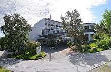 The entrance to NGUs headquarters in Trondheim, Norway | |
| Government agency overview | |
|---|---|
| Type | Geological survey |
| Headquarters |
Trondheim, Norway 63°27′18″N 10°26′42″E / 63.45500°N 10.44500°E |
| Motto | Geology for the scociety |
| Employees | 225 |
| Annual budget | 260 million NOK |
| Minister responsible |
|
| Parent department | Norwegian Ministry of Trade and Industry |
| Child agencies |
|
| Website | www.ngu.no |

Norwegian Geological Survey (Norwegian: Norges Geologiske Undersøkelse), abbr:NGU is a Norwegian government agency responsible for geologic mapping and research. The agency is located in Trondheim with an office in Tromsø, with about 225 employees. It is subordinate to the Norwegian Ministry of Trade and Industry.[1]
Mission
NGU's main work is related to collecting, processing and impart knowledge related to the physical, chemical and mineralogical characteristics of the countries bedrock, deposits and groundwater.[2] Important areas include the Arctic, Antarctica, Svalbard and the continental shelf. With the motto "Geology for the Scociety", NGU provides maps and geological information in national databases. The activity is organized after four key principles:[3]
- Sustainable added value from geological resources
- Effective use of geoscience knowledge in land-use planning and development
- Better knowledge of geological development and processes in Norway
- Management and dissemination of geological data and knowledge
History
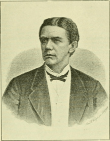
The Norwegian Geological Survey was established on the 6th of February 1858 by Order in Council. A few years earlier, the geology student Theodor Kjerulf had submitted the idea of a Norwegian geological survey to the Norwegian interior ministry.[4] The survey would serve to map the country´s agricultural areas and mineral deposits, as well as systematically study how the Norwegian landscape had been formed. In the mid-19th century Norway was modernizing quickly by developing industry and knowledge, along with evolving cultural life. An institution such as a Norwegian geological survey would be "convenient, scientifically necessary and honorable for the nation". The first years of its existence, mapping the bedrock, superficial deposits and mineral resources was its principal task, but it contributed to a Norwegian sense of ownership to the land, something that was especially important around 1905, after the Union with Sweden was dissolved. The manager Theodor Kjerulf, and his assistant, Tellef Dahll, shared the mapping of Norway. They purchased equipment, planned the work and trained their field assistants to carry out the surveys.
Manager Kjerulf along with Dahll and several assistants had, after about twenty years of work, completed three impressive sets of maps. Det sødenfjeldske in 1:400 000, Trondheim stift in 1:800 000 and Det nordlige Norge in 1:1 million. The maps and their descriptions gave new and valuable knowledge about the Norwegian landscape, and showed that it was possible to combine the scientific, economical and cultural ambitions Kjerulf had fronted when he set out to create the survey.
Organization
There are six support divisions within the agency:
- Geoenvironment
- Marine geology
- Groundwater and urban geology
- NGU-laboratory
- Geomapping
- Bedrock geology
- Quaternary geology
- Geodynamics
- Geohazards
- Continental shelf geophysics
- Georescources
- Mineral rescources
- Natural construction minerals
- Applied geophysics
- Geochemistry
- Geomatics & IT
- Geomatics
- IT
- HR & rescource management
- HR
- Rescource management
- Communications and public relations
- Communication
Directors
| Manager | Timespan |
|---|---|
| Theodor Kjerulf | 6. February 1858 – 1888 |
| Hans Henrik Reusch | 1888–1921 |
| The title manager was replaced by Director-general in 1915. | |
| Carl Bugge | 1921–1951 |
| Sven Føyn | 1951–1958 |
| Harald Bjørlykke | 1958–1963 |
| Karl Ingvaldsen | 1963–1973 |
| Knut Heier | 1974–1994 |
| Arne Bjørlykke | 1994 – 1 August. 2006 |
| Morten Smelror | 1 August. 2006 - |