Florida Panhandle
- For a list of other political entities with similar geographic extensions, see Salient (geography)
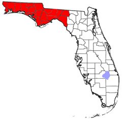
The Florida Panhandle, Northwest Florida, or West Florida, an informal, unofficial term for the northwestern part of the U.S. state of Florida, is a strip of land roughly 200 miles wide and 50 to 100 miles long (320 km by 80 to 160 km), lying between Alabama on the north and the west, Georgia also on the north, and the Gulf of Mexico to the south. Its eastern boundary is arbitrarily defined. The terms West Florida and Northwest Florida are today generally synonymous with the Panhandle, although historically West Florida was the name of a British colony (1763–1783), later a Spanish colony (1783–1821), both of which included modern-day Florida west of the Apalachicola River as well as portions of what are now Alabama, Mississippi, and Louisiana.
As is the case with the other eight U.S. states that have panhandles, the geographic meaning of the term is inexact and elastic. References to the Florida Panhandle always include the ten counties west of the Apalachicola River, a natural geographic boundary, which was the historic dividing line between the British colonies of West Florida and East Florida. These western counties also lie in the Central Time Zone (with the exception of Gulf County, which is divided between the Eastern and Central Time zones), while the rest of the state is in the Eastern Time Zone.
References to the Panhandle may also include some or all of eight counties immediately east of the Apalachicola known as the Big Bend region, along the curve of Apalachee Bay. The largest city in the Panhandle is Tallahassee, the state capital, population 188,107 (2014). However, the largest population grouping is the Pensacola Metropolitan Area with a population of 474,081. The total population of the Panhandle, as of the 2010 Census, was 1,407,925.
Coastal regions
Emerald Coast

Emerald Coast, a term coined in 1983,[1] refers in general to the beaches and coastal resorts from Pensacola to Port St. Joe,[Emerald_Coast 1] but is sometimes used to refer, by extension, to the Panhandle as a whole, especially west of the Apalachicola. Earlier designations include "Playground of the Gulfcoast" and the "Miracle Strip", especially for the area between Fort Walton Beach and Panama City.[2] Coastal regions of the following counties (if not the entirety of the counties themselves) are usually included when referring to the Emerald Coast:
- Okaloosa County[Emerald_Coast 2][Emerald_Coast 3]
- Santa Rosa County[Emerald_Coast 4]
- Walton County[Emerald_Coast 5]
Coastal portions of Escambia County (namely Pensacola Beach) that lie on the western edge, and coastal portions of Bay County that lie on the eastern edge, are also regularly included when referring to the Emerald Coast, but with somewhat less regularity than the three aforementioned counties listed above.
Forgotten Coast
The Forgotten Coast is a trademarked term first coined in the early 1990s[3] used to refer to the coastal portion of the Florida Panhandle extending from Mexico Beach or southeastern Bay County on the Gulf of Mexico to St. Marks on Apalachee Bay. It is usually not considered a part of the Emerald Coast, which lies directly adjacent to the west.[4] Coastal regions of the following counties (if not the entirety of the counties themselves) are usually included when referring to the Forgotten Coast:
- Gulf County
- Franklin County
- Wakulla County
- Small portions of Bay County
Physical features
The Apalachicola River is the largest river of the Panhandle. It is formed by the junction of several rivers, including the Chattahoochee and the Flint, where the boundaries of Alabama, Georgia, and Florida meet. From there, it flows due south to the town of Apalachicola.
Interstate 10 is the only major interstate highway in the Panhandle, connecting the extreme west with North Florida and Jacksonville. Other older east–west routes include U.S. Highway 90 and U.S. Highway 98. Important north–south routes west of the Apalachicola River include U.S. Highway 29, U.S. Highway 331, and U.S. Highway 231, all linking to Alabama and Interstate 65.
State Road 20 stretches from Niceville to Tallahassee.
The major railroad line through the Panhandle, running from Pensacola to Jacksonville, is owned by CSX railroad. (See Pensacola and Atlantic Railroad.) Passenger service ended with the creation of Amtrak in 1971, but was revived with the extension of the Sunset Limited to Orlando beginning in 1993; however, passenger service was discontinued after Hurricane Katrina struck the Gulf Coast in 2005. Regional short-line railroads serving the Panhandle are the Alabama and Gulf Coast Railway, the Bay Line Railroad and the AN Railway.
Like North Central Florida, this region is more similar in culture and climate to the Deep South than to South Florida in the lower peninsula, being known for its conservative politics and "piney woods."[5]
History
19th century
Throughout the 19th century, the Panhandle was sparsely populated, dotted in places with small farming communities, none of which had as many as a thousand residents. Many Panhandle residents had, in fact, migrated to the area from Alabama and had relatives there; it was also easier to trade with and travel to southern Alabama than to reach East Florida by slow, arduous journey across the thick cypress swamps and dense pine forests of the Panhandle. It was natural for West Floridians to feel that they had more in common with their nearby neighbors in Alabama than with the residents of the peninsula, hundreds of miles away.[6]
In 1821, Pensacola was the only city (in 19th-century terms) in West Florida, with a population estimated to be about 3,000. In the 1850 census, the enumerated population of Pensacola was 2,164 (including 741 slaves and 350 "free Negroes").[7]
Alabama annexation proposals
During the course of the century, proposals for ceding the Florida counties west of the Apalachicola River to Alabama were often raised:
- In 1811, while Florida was still a Spanish possession, American residents sent a petition to Congress asking to be incorporated into the Mississippi Territory, which at that time included present-day Alabama.[8] (See West Florida article.)
- In 1819, the constitutional convention of Alabama asked Congress to include West Florida in their new state.[8]
- In 1822, only a year after the U.S. acquired the entire Florida territory from Spain, residents of West Florida sent a petition to the U.S. House of Representatives asking that their section be annexed to Alabama, and Alabama Senator John Williams Walker also promoted the idea.[7]
- In 1826, the Pensacola Gazette published a number of letters advocating annexation to Alabama, though the editor remarked that some Pensacolians opposed the idea.[7]
- In 1840, a public meeting in Pensacola produced a demand that West Florida be united with Alabama. In the same year, the territorial Legislature notified Congress that it opposed allowing Alabama to annex West Florida, but in 1844, the year before statehood, the Legislature reversed its stance and asked that West Florida be separated.[7]
- In 1856, advocates of annexation were able to get a bill passed by the Legislature authorizing a referendum on the issue but the Governor James E. Broome vetoed the measure. The Pensacola Gazette reported that "annexation is desired by a large majority of the people" of the area.[7]
- In 1858, the Alabama Legislature unsuccessfully tried to open negotiations with Florida on the subject.[8]
- The annexation issue was eclipsed by the Civil War and the war's effects on the region, but in 1868, with Pensacola now connected by the Panhandle's sole railroad line to the Alabama cities of Mobile and Montgomery, the issue came to a head again and was finally put to a vote of the people. In that year, the Alabama Legislature approved a joint resolution authorizing their Governor to negotiate with the Governor of Florida about the annexation of West Florida. An offer of one million dollars in Alabama state bonds, paying 8 percent interest for thirty years, was included. Both states appointed commissioners to make detailed recommendations on the matter.[9]
- On November 2, 1869, a referendum was held in the West Florida counties (except Jackson, which was in the throes of bloody racial violence[10]), with a result of 1162 to 661 in favor of annexation.[6] However, political objection developed in Alabama to the high price, and the Legislature took no action on the results of the referendum.[8][11]
- In 1873, a similar proposal was made in the Alabama Legislature, which the state senate approved, though it did not pass a separate proposal to finance the measure by selling all of Alabama's territory west of the Tombigbee River, including the city of Mobile, to Mississippi.[12] However, nothing came of this action.
- In 1901, Alabama made yet another offer when the Legislature appointed a commission to negotiate with Florida about annexation, but this attempt, too, was unsuccessful.[8]
The building of the Pensacola and Atlantic Railroad, completed in 1883, finally linked Pensacola and the Panhandle solidly with the rest of the state and ended the region's isolation, although from time to time during the twentieth century there were still occasional calls for annexation that generated some public discussion but no legislative action.
20th century
The area was a prime target of the 1993 Storm of the Century. Hurricanes that directly struck the area include Hurricane Eloise in 1976, Hurricane Erin and Hurricane Opal, both in 1995.
21st century
The Panhandle suffered direct hits from Hurricane Ivan in 2004 and Hurricane Dennis in 2005. Ivan was the most disastrous, making landfall near Gulf Shores, Alabama, with 120 mile-per-hour (193 kph) winds and a 14-foot (4.3 m) storm surge that devastated Perdido Key and Santa Rosa Island, wrecked the Interstate 10 bridge across Escambia Bay, and destroyed thousands of homes in the region, some as far away as 20 miles (32 km) inland.
On June 23, 2010, oil from the Deepwater Horizon oil spill landed on Pensacola Beach and Navarre Beach, damaging the fishing and tourism industries, and prompting a massive clean-up effort.
Economy
Historically, the economy of the Panhandle depended mainly on farming, forestry and lumbering, paper mills, import/export shipping at Pensacola and to a lesser extent at Panama City, shipbuilding, and commercial fishing. After World War II, the economy was boosted by the numerous military bases established in the region, as well as the growth of tourism and the hospitality industry.
Major employers in the second half of the twentieth century included Monsanto and Westinghouse plants at Pensacola, the St. Joe Paper Company in Port St. Joe, and Gulf Power, a major electric utility company.
Unlike central and southern Florida, the Panhandle has never been a producer of citrus crops because the area is subject to regular frosts and freezes in wintertime, which destroy citrus fruits.
Education
The following institutions of higher learning are located in the Panhandle.
State University System:
- Florida Agricultural and Mechanical University (Tallahassee)
- Florida State University (Tallahassee)
- University of West Florida (Pensacola)
Florida College System:
- Chipola College (Marianna)
- Gulf Coast State College (Panama City)
- Northwest Florida State College (Niceville)
- Pensacola State College (Pensacola)
- Tallahassee Community College (Tallahassee)
Religiously affiliated:
Private institutions:
Politics
The politics of the Florida Panhandle vary considerably depending on location. The western Panhandle is the most Republican area of Florida, with the counties along the Emerald Coast regularly giving Republicans close to or over 70% margins in state and national elections. However, Tallahassee and Gadsden County tend to be strongly Democratic, due to a large African-American population and the presence of two large state universities (see Leon County for a breakdown of education and electoral numbers). In the 2008 Presidential election, John McCain received 421,287 votes (60.1%) in the Panhandle, while Barack Obama received 279,206 votes (39.9%).
Culture
- Springtime Tallahassee
- Tallahassee Wine and Food Festival
- Red Hills Horse Trials
- Florida State Seminoles
- Florida A&M Rattlers
- Pensacola Blue Wahoos
- Pensacola Ice Flyers
Counties
The following counties west of the Apalachicola River are always included in references to the Panhandle:
Some or all of the following counties east of the Apalachicola, in the Big Bend subregion, are sometimes considered part of the Panhandle:
Cities and towns
Places marked with an asterisk (*) lie east of the Apalachicola River, and may not be considered part of the Panhandle by some residents or writers.
Population of the major metropolitan areas in the Panhandle:
- Pensacola-Ferry Pass-Brent Metropolitan Statistical Area - 455,102 (2009)
- Fort Walton Beach-Crestview-Destin, Florida Metropolitan Statistical Area - 180,822 (2010)
- Panama City-Lynn Haven-Panama City Beach Metropolitan Statistical Area - 168,852 (2010)
- Tallahassee Standard Metropolitan Statistical Area - 367,413 (2010)
Beaches
The Panhandle is renowned for the white-sand beaches and blue-green waters of its barrier islands fronting the Gulf of Mexico. According to the National Park Service:[13]
The stunning sugar-white beaches of Gulf Islands National Seashore are composed of fine quartz eroded from granite in the Appalachian Mountains. The sand is carried seaward by rivers and creeks and deposited by currents along the shore.
The beach towns in the Panhandle, many of which play host to college students during spring break, are sometimes derisively called the Redneck Riviera.[14] The term was used as the title of a song by country music artist Tom T. Hall on his 1996 album Songs from Sopchoppy. The album takes its name from a town in rural Wakulla County, near Tallahassee.
Tourists have been drawn to the Panhandle since the building of the Pensacola and Atlantic Railroad in the 1880s. Pensacola Beach has been a major tourist attraction since the building of bridges between the mainland and Santa Rosa Island in 1931.[15] After World War II, an increase in both tourism and population of the area led to a proliferation of motels, restaurants, bars, tourist attractions, and amusement parks along the coast, concentrated in Pensacola Beach, Fort Walton Beach, and Panama City Beach. Examples include the Gulfarium marine park and aquarium in Fort Walton Beach,[16] and the former Miracle Strip Amusement Park (1963–2004) in Panama City Beach.
In 1971, the federal government acquired many acres of the coastal islands in Escambia, Santa Rosa, and Okaloosa counties, preserving them from commercial development by establishing the Gulf Islands National Seashore, which also covers some islands off the Mississippi coast. Other beach areas protected by the state of Florida include
- Perdido Key State Park
- Big Lagoon State Park
- Navarre Beach State Park
- Henderson Beach State Park
- Grayton Beach State Park
- St. Andrews State Park
- St. Joseph Peninsula State Park
- St. George Island State Park
Both state and federal parks offer facilities for camping, picknicking, and other recreational pursuits. In addition, some parts of the coastline are federal property belonging to Pensacola Naval Air Station, Eglin Air Force Base, and Tyndall Air Force Base, and so are likewise protected from commercial development.
In addition, seven state aquatic preserves, covering thousands of acres of submerged lands in coastal areas, are located in the Panhandle.[17] A number of other state parks, preserves, and forests are located inland.
The 1970s also saw the beginnings of a number of upscale beach resorts, condominium towers, vacation homes, and planned communities, such as Seaside and Sandestin, so that most of the privately owned areas of the coastline are now heavily developed.
Military bases
Major military bases include the Pensacola Naval Air Station (the home of Naval Aviation in the United States), Eglin Air Force Base and Hurlburt Field near Ft. Walton Beach, Naval Support Activity Panama City in Panama City Beach, and Tyndall Air Force Base near Panama City.
The 1983-84 television show Emerald Point N.A.S. was set in a naval air station somewhere in the American South, similar to Pensacola NAS. The 1997-2000 action/adventure series Pensacola: Wings of Gold was explicitly set there.
See also
References
- ↑ "Who owns 'Emerald Coast'?", Northwest Florida Daily News, June 29, 2011, accessed July 10, 2011.
- ↑ The Florida Handbook, Peninsular Publishing, 1985.
- ↑ United States Patent and Trademark Office Searching on this site reveals that the name was "first used in commerce" in 1992; the ABCofC registered the trademark in 2009.
- ↑ Reiley, Laura. "The Forgotten Coast", Moon Florida Gulf Coast, Avalon Travel Publishing, 2008, pp. 262–289. ISBN 1-59880-082-5.
- ↑ A Newsweek article in 1972, referring to then United States Senator Lawton Chiles, said "In 1958, he was elected to the state legislature from the ultraconservative piney-woods panhandle of Florida."
- 1 2 The American Annual Cyclopaedia and Register of Important Events of the Year 1869, vol. IX, D. Appleton and Co., New York, pp. 10, 268
- 1 2 3 4 5 Herbert J. Doherty, "Ante-bellum Pensacola: 1821–1860, Florida Historical Quarterly, January 1959
- 1 2 3 4 5 The South in the Building of the Nation: Political History, vol. 4, p. 83, ed. F. L. Riley, 1909
- ↑ Joint Resolution No. 7, "Relating to Annexation of West Florida," Acts of the Legislature of Alabama, 1868
- ↑ The Jackson County War (blog)
- ↑ The American Annual Cyclopaedia and Register of Important Events of the Year 1870, vol. 10, D. Appleton and Co., New York, p. 9
- ↑ Journal of the Session of 1872–1873 of the Senate of Alabama, pp. 100 ff.
- ↑ "Directions to the Florida District," Gulf Islands National Seashore, National Park Service, accessed 10 July 2011
- ↑ "Alabama Town Says No Thanks to 'Redneck Riviera,' Passes Law to Block Filming," ABC News, 5 Oct. 2010, accessed 10 July 2011
- ↑ "Pensacola Beach," Pensapedia, accessed 10 July 2011
- ↑ http://www.gulfarium.com/ Florida's Gulfarium Marine Show Aquarium
- ↑ "CAMA Office Closures," Florida Department of Environmental Protection, accessed 10 July 2011
- ↑ ChananEstates.com. "Chanan Estates in the Emerald Coast". ChananEstates.com. Chanan Estates Property Owners' Association. p. http://www.chananestates.com/index.html. Retrieved April 16, 2013.
- ↑ The Emerald Coast Convention and Visitors Bureau, Inc. "Official Site". Northwest Florida's Emerald Coast. p. http://www.emeraldcoastfl.com/index.html. Retrieved April 16, 2013.
- ↑ TripAdvisor, LLC. "Emerald Coast - Florida - Reviews of Emerald Coast". TripAdvisor. p. http://www.tripadvisor.com/Attraction_Review-g28930-d524800-Reviews-Emerald_Coast-Florida.html. Retrieved April 16, 2013.
- ↑ Miles Media Group, Inc. "Emerald Coast - SEE-Florida". SEE-Florida. p. http://www.see-florida.com/emerald-coast. Retrieved April 16, 2013.
- ↑ South Walton Tourist Development Council. "South Walton State Parks - South Walton, Florida". VisitSouthWalton.com | The Official South Walton Tourism Site. VisitSouthWalton.com. p. http://www.visitsouthwalton.com/grayton-beach-state-park. Retrieved April 16, 2013.
Grayton Beach State Park is among the priceless natural treasures of Florida’s Emerald Coast.
External links
| Wikivoyage has a travel guide for Florida Panhandle. |
- Outdoor Gulf Coast – Online recreation for Northwest Florida
- Panama City Beach Convention & Visitors Bureau – Official online travel planning resource for Panama City Beach
- Historic Pensacola Village and T. T. Wentworth, Jr., State Museum
Bibliography
- DeBolt, Dean. "The Florida Panhandle," pp. 404–445 in The Book Lover's Guide to Florida, ed. Kevin M. McCarthy. Sarasota, Florida: Pineapple Press, 1992. ISBN 978-1-56164-012-6 (Contains an extensive bibliography of fiction and nonfiction works about people and places in the Panhandle.)
- Hollis, Tim. Florida’s Miracle Strip: From Redneck Riviera to Emerald Coast. University Press of Mississippi, 2004. ISBN 978-1-57806-627-8
- King, Heidi Tyline. The Pelican Guide to the Florida Panhandle. Pelican Publishing, 1999. ISBN 1-56554-308-4
- O'Donovan, Michael, and Robin Rowan. Florida's Northwest: First Places, Wild Places, Favorite Places. Terra Nova Publishing, 2005. ISBN 0-9651034-3-9
- Ziewitz, Kathryn, and June Wiaz. Green Empire: The St. Joe Company and the Remaking of Florida's Panhandle. University Press of Florida, 2006. ISBN 0-8130-2951-1

Coordinates: 30°26′N 85°11′W / 30.43°N 85.19°W