Northvale, New Jersey
| Northvale, New Jersey | |
|---|---|
| Borough | |
| Borough of Northvale | |
|
| |
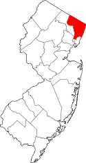
 Map highlighting Northvale's location within Bergen County. Inset: Bergen County's location within New Jersey. | |
 Census Bureau map of Northvale, New Jersey | |
| Coordinates: 41°00′47″N 73°56′53″W / 41.013°N 73.948085°WCoordinates: 41°00′47″N 73°56′53″W / 41.013°N 73.948085°W[1][2] | |
| Country |
|
| State |
|
| County | Bergen |
| Incorporated | March 15, 1916 |
| Government[3] | |
| • Type | Borough |
| • Body | Borough Council |
| • Mayor | Stanley E. "Ed" Piehler (term ends December 31, 2018)[4][5] |
| • Clerk | Wanda A. Worner[6] |
| Area[1] | |
| • Total | 1.298 sq mi (3.362 km2) |
| • Land | 1.295 sq mi (3.355 km2) |
| • Water | 0.003 sq mi (0.007 km2) 0.20% |
| Area rank |
472nd of 566 in state 59th of 70 in county[1] |
| Elevation[7] | 46 ft (14 m) |
| Population (2010 Census)[8][9][10] | |
| • Total | 4,640 |
| • Estimate (2015)[11] | 4,859 |
| • Rank |
390th of 566 in state 62nd of 70 in county[12] |
| • Density | 3,582.3/sq mi (1,383.1/km2) |
| • Density rank |
177th of 566 in state 37th of 70 in county[12] |
| Time zone | Eastern (EST) (UTC-5) |
| • Summer (DST) | Eastern (EDT) (UTC-4) |
| ZIP code | 07647[13][14] |
| Area code(s) | 201 exchanges: 750, 767, 768, 784[15] |
| FIPS code | 3400353430[1][16][17] |
| GNIS feature ID | 0885327[1][18] |
| Website |
www |

Northvale is a borough in Bergen County, New Jersey, United States. As of the 2010 United States Census, the borough's population was 4,640,[8][9][10] reflecting an increase of 180 (+4.0%) from the 4,460 counted in the 2000 Census, which had in turn declined by 103 (-2.3%) from the 4,563 counted in the 1990 Census.[19]
History
The borough of Northvale was formed on March 15, 1916, from the remaining portions of Harrington Township, based on the results of a referendum held on April 4, 1916. With the creation of Northvale, Harrington Township was dissolved. Portions of Northvale were transferred to create the borough of Rockleigh, as of March 13, 1923.[20] The borough's name derives from its location and topography.[21]
Geography
According to the United States Census Bureau, the borough had a total area of 1.298 square miles (3.362 km2), including 1.295 square miles (3.355 km2) of land and 0.003 square miles (0.007 km2) of water (0.20%).[1][2]
The borough borders Norwood, Old Tappan and Rockleigh in Bergen County and Tappan (in the Town of Orangetown) in Rockland County, New York.[22]
Demographics
| Historical population | |||
|---|---|---|---|
| Census | Pop. | %± | |
| 1900 | 387 | — | |
| 1910 | 588 | 51.9% | |
| 1920 | 827 | 40.6% | |
| 1930 | 1,144 | * | 38.3% |
| 1940 | 1,159 | 1.3% | |
| 1950 | 1,455 | 25.5% | |
| 1960 | 2,892 | 98.8% | |
| 1970 | 5,177 | 79.0% | |
| 1980 | 5,046 | −2.5% | |
| 1990 | 4,563 | −9.6% | |
| 2000 | 4,460 | −2.3% | |
| 2010 | 4,640 | 4.0% | |
| Est. 2015 | 4,859 | [11][23] | 4.7% |
| Population sources: 1920[24] 1910-1930[25] 1900-2010[26][27][28] 2000[29][30] 2010[8][9][10] * = Lost territory in previous decade.[20] | |||
2010 Census
The 2010 United States Census counted 4,640 people, 1,564 households, and 1,265 families residing in the borough. The population density was 3,582.3 per square mile (1,383.1/km2). The borough contained 1,635 housing units at an average density of 1,262.3 per square mile (487.4/km2). The racial makeup of the borough was 71.94% (3,338) White, 1.06% (49) Black or African American, 0.19% (9) Native American, 24.01% (1,114) Asian, 0.02% (1) Pacific Islander, 1.14% (53) from other races, and 1.64% (76) from two or more races. Hispanics or Latinos of any race were 8.15% (378) of the population.[8] Korean Americans accounted for 16.3% of the population.[8]
Out of a total of 1,564 households, 38.7% had children under the age of 18 living with them, 67.8% were married couples living together, 10.0% had a female householder with no husband present, and 19.1% were non-families. 16.3% of all households were made up of individuals, and 8.8% had someone living alone who was 65 years of age or older. The average household size was 2.96 and the average family size was 3.32.[8]
In the borough, 25.2% of the population were under the age of 18, 6.7% from 18 to 24, 23.2% from 25 to 44, 30.3% from 45 to 64, and 14.6% who were 65 years of age or older. The median age was 42.2 years. For every 100 females the census counted 98.7 males, but for 100 females at least 18 years old, it was 93.8 males.[8]
The Census Bureau's 2006-2010 American Community Survey showed that (in 2010 inflation-adjusted dollars) median household income was $86,607 (with a margin of error of +/- $13,519) and the median family income was $89,125 (+/- $16,380). Males had a median income of $66,563 (+/- $14,582) versus $31,228 (+/- $7,496) for females. The per capita income for the borough was $35,404 (+/- $4,301). About 3.7% of families and 4.1% of the population were below the poverty line, including 1.7% of those under age 18 and 5.9% of those age 65 or over.[31]
Same-sex couples headed 9 households in 2010, an increase of 50% from the 6 counted in 2000.[32]
2000 Census
As of the 2000 United States Census[16] there were 4,460 people, 1,575 households, and 1,236 families residing in the borough. The population density was 3,381.2 people per square mile (1,304.6/km2). There were 1,596 housing units at an average density of 1,210.0 per square mile (466.8/km2). The racial makeup of the borough was 82.91% White, 0.76% African American, 0.07% Native American, 14.06% Asian, 1.17% from other races, and 1.03% from two or more races. Hispanic or Latino of any race were 4.73% of the population.[29][30]
There were 1,575 households out of which 33.6% had children under the age of 18 living with them, 66.2% were married couples living together, 8.1% had a female householder with no husband present, and 21.5% were non-families. 18.5% of all households were made up of individuals and 10.3% had someone living alone who was 65 years of age or older. The average household size was 2.83 and the average family size was 3.21.[29][30]
In the borough the population was spread out with 22.5% under the age of 18, 6.4% from 18 to 24, 29.3% from 25 to 44, 25.9% from 45 to 64, and 16.0% who were 65 years of age or older. The median age was 40 years. For every 100 females there were 99.3 males. For every 100 females age 18 and over, there were 94.2 males.[29][30]
The median income for a household in the borough was $72,500, and the median income for a family was $81,153. Males had a median income of $50,901 versus $37,563 for females. The per capita income for the borough was $28,206. About 2.4% of families and 3.9% of the population were below the poverty line, including 6.9% of those under age 18 and 1.4% of those age 65 or over.[29][30]
Government
Local government
Northvale is governed under the Borough form of New Jersey municipal government. The governing body consists of a Mayor and a Borough Council comprising six council members, with all positions elected at-large on a partisan basis as part of the November general election. A Mayor is elected directly by the voters to a four-year term of office. The Borough Council consists of six members elected to serve three-year terms on a staggered basis, with two seats coming up for election each year in a three-year cycle.[3] The Borough form of government used by Northvale, the most common system used in the state, is a "weak mayor / strong council" government in which council members act as the legislative body with the mayor presiding at meetings and voting only in the event of a tie. The mayor can veto ordinances subject to an override by a two-thirds majority vote of the council. The mayor makes committee and liaison assignments for council members, and most appointments are made by the mayor with the advice and consent of the council.[33][34]
As of 2016, the Mayor of Northvale is Democrat Stanley E. "Ed" Piehler, whose term of office ends December 31, 2018. Members of the Borough Council are Council President Patrick Marana (D, 2016), Toni M. Macchio (D, 2018), Ken Shepard (D, 2017), Michael Small (D, 2016; appointed to serve an unexpired term), Roy Sokoloski (R, 2017) and Peter Sotiropoulos (R, 2018).[4][35][36][37][38][39]
In December 2015, the borough council selected Michael Small to fill the seat vacated by Gloria Libby, who left office earlier that month to follow her employer, Mercedes-Benz USA, which had relocated its headquarters from Bergen County to Atlanta.[40]
Federal, state and county representation
Northvale is located in the 5th Congressional District[41] and is part of New Jersey's 37th state legislative district.[9][42][43] Prior to the 2011 reapportionment following the 2010 Census, Northvale had been in the 39th state legislative district.[44]
New Jersey's Fifth Congressional District is represented by Scott Garrett (R, Wantage Township).[45] New Jersey is represented in the United States Senate by Cory Booker (D, Newark, term ends 2021)[46] and Bob Menendez (D, Paramus, 2019).[47][48]
For the 2016–2017 session (Senate, General Assembly), the 37th Legislative District of the New Jersey Legislature is represented in the State Senate by Loretta Weinberg (D, Teaneck) and in the General Assembly by Valerie Huttle (D, Englewood) and Gordon M. Johnson (D, Englewood).[49] The Governor of New Jersey is Chris Christie (R, Mendham Township).[50] The Lieutenant Governor of New Jersey is Kim Guadagno (R, Monmouth Beach).[51]
Bergen County is governed by a directly elected County Executive, with legislative functions performed by a seven-member Board of Chosen Freeholders.[52] As of 2015, the County Executive is James J. Tedesco III (D, Paramus; term ends December 31, 2018).[53] The seven freeholders are elected at-large in partisan elections on a staggered basis, with two or three seats coming up for election each year, with a Chairman, Vice Chairman and Chairman Pro Tempore selected from among its members at a reorganization meeting held each January.[54] Bergen County's Freeholders are Freeholder Chairwoman Joan Voss (D, 2017; Fort Lee),[55] Vice Chairman Steve Tanelli (D, 2015; North Arlington)[56] Chairman Pro Tempore John A. Felice (R, 2016; River Edge),[57] David L. Ganz (D, 2017; Fair Lawn),[58] Maura R. DeNicola (R, 2016; Franklin Lakes)[59] Thomas J. Sullivan Jr., (D, Montvale, 2015; serving the unexpired term of office that had been occupied by James Tedesco before he was sworn in as County Executive)[60][61] and Tracy Silna Zur (D, 2015; Franklin Lakes).[62][63] Countywide constitutional officials are County Clerk John S. Hogan (D, Northvale),[64] Sheriff Michael Saudino (R)[65] and Surrogate Michael R. Dressler (D, Cresskill).[66][67][52]
Politics
As of March 23, 2011, there were a total of 2,699 registered voters in Northvale, of which 701 (26.0% vs. 31.7% countywide) were registered as Democrats, 560 (20.7% vs. 21.1%) were registered as Republicans and 1,437 (53.2% vs. 47.1%) were registered as Unaffiliated. There was one voter registered to another party.[68] Among the borough's 2010 Census population, 58.2% (vs. 57.1% in Bergen County) were registered to vote, including 77.7% of those ages 18 and over (vs. 73.7% countywide).[68][69]
In the 2012 presidential election, Republican Mitt Romney received 1,100 votes (53.3% vs. 43.5% countywide), ahead of Democrat Barack Obama with 924 votes (44.8% vs. 54.8%) and other candidates with 21 votes (1.0% vs. 0.9%), among the 2,064 ballots cast by the borough's 2,825 registered voters, for a turnout of 73.1% (vs. 70.4% in Bergen County).[70][71] In the 2008 presidential election, Republican John McCain received 1,206 votes (54.9% vs. 44.5% countywide), ahead of Democrat Barack Obama with 949 votes (43.2% vs. 53.9%) and other candidates with 14 votes (0.6% vs. 0.8%), among the 2,198 ballots cast by the borough's 2,798 registered voters, for a turnout of 78.6% (vs. 76.8% in Bergen County).[72][73] In the 2004 presidential election, Republican George W. Bush received 1,188 votes (55.9% vs. 47.2% countywide), ahead of Democrat John Kerry with 912 votes (42.9% vs. 51.7%) and other candidates with 14 votes (0.7% vs. 0.7%), among the 2,125 ballots cast by the borough's 2,743 registered voters, for a turnout of 77.5% (vs. 76.9% in the whole county).[74]
In the 2013 gubernatorial election, Republican Chris Christie received 65.8% of the vote (876 cast), ahead of Democrat Barbara Buono with 32.6% (434 votes), and other candidates with 1.7% (22 votes), among the 1,371 ballots cast by the borough's 2,739 registered voters (39 ballots were spoiled), for a turnout of 50.1%.[75][76] In the 2009 gubernatorial election, Republican Chris Christie received 842 votes (54.1% vs. 45.8% countywide), ahead of Democrat Jon Corzine with 606 votes (38.9% vs. 48.0%), Independent Chris Daggett with 73 votes (4.7% vs. 4.7%) and other candidates with 5 votes (0.3% vs. 0.5%), among the 1,557 ballots cast by the borough's 2,722 registered voters, yielding a 57.2% turnout (vs. 50.0% in the county).[77]
Education
The Northvale Public Schools serve students in Kindergarten through eighth grade at Northvale Public School. As of the 2011-12 school year, the district's then two schools had an enrollment of 567 students and 45.9 classroom teachers (on an FTE basis), for a student–teacher ratio of 12.35:1.[78] Schools in the district (with 2011-12 enrollment data from the National Center for Education Statistics[79]) were Thomas Jefferson School for grades K-4 (208 students) and Nathan Hale School for grades 5-8 (359). As of the 2012-13 school year, the two schools were combined to create the Northvale Public School, as part of an effort to reduce costs associated with running two separate schools that share a common campus and corridor.[80]
Students in public school for ninth through twelfth grades attend Northern Valley Regional High School at Old Tappan, together with students from Harrington Park, Norwood and Old Tappan,[81] along with students from Rockleigh who attend the high school as part of a sending/receiving relationship.[82] The school is one of the two schools of the Northern Valley Regional High School District, which also serves students from the neighboring communities of Closter, Demarest and Haworth at the Northern Valley Regional High School at Demarest.[83][84] During the 1994-96 school years, Northern Valley Regional High School at Old Tappan was awarded the Blue Ribbon School Award of Excellence by the United States Department of Education.[85] As of the 2013-14 school year, the high school had an enrollment of 1,303 students and 100.4 classroom teachers (on an FTE basis), for a student–teacher ratio of 13.0:1.[86]
Public school students from the borough, and all of Bergen County, are eligible to attend the secondary education programs offered by the Bergen County Technical Schools, which include the Bergen County Academies in Hackensack, and the Bergen Tech campus in Teterboro or Paramus. The district offers programs on a shared-time or full-time basis, with admission based on a selective application process and tuition covered by the student's home school district.[87][88]
Transportation
Roads and highways
As of May 2010, the borough had a total of 22.67 miles (36.48 km) of roadways, of which 20.11 miles (32.36 km) were maintained by the municipality and 2.56 miles (4.12 km) by Bergen County.[89]
County Route 505 passes through Northvale.
Public transportation
Rockland Coaches provides service on routes 20/20T to the Port Authority Bus Terminal in Midtown Manhattan.[90][91]
Saddle River Tours / Ameribus offers service on the 20 / 84 route to the George Washington Bridge Bus Station.[92][93]
In popular culture
The television show Ed, which ran from 2000–04, was filmed in Northvale. The interior and exterior shots for "Stuckeybowl" were filmed at the now closed and demolished bowling alley, formerly known as "Country Club Lanes".[94] Housing for seniors ages 55+ now exists on the site.
In the 2008 USA Network series In Plain Sight, during the episode, Stan by Me, two FBI agents are murdered and a federally protected witness is kidnapped in Northvale.
Historic sites
Haring-Blauvelt House was built in 1810 and was added to the National Register of Historic Places on January 10, 1983.[95]
References
- 1 2 3 4 5 6 2010 Census Gazetteer Files: New Jersey County Subdivisions, United States Census Bureau. Accessed May 21, 2015.
- 1 2 US Gazetteer files: 2010, 2000, and 1990, United States Census Bureau. Accessed September 4, 2014.
- 1 2 2012 New Jersey Legislative District Data Book, Rutgers University Edward J. Bloustein School of Planning and Public Policy, March 2013, p. 165.
- 1 2 2016 Mayor & Council, Borough of Northvale. Accessed June 19, 2016.
- ↑ 2016 New Jersey Mayors Directory, New Jersey Department of Community Affairs. Accessed June 14, 2016.
- ↑ Borough Clerk, Borough of Northvale. Accessed May 20, 2016.
- ↑ U.S. Geological Survey Geographic Names Information System: Borough of Northvale, Geographic Names Information System. Accessed March 8, 2013.
- 1 2 3 4 5 6 7 DP-1 - Profile of General Population and Housing Characteristics: 2010 for Northvale borough, Bergen County, New Jersey, United States Census Bureau. Accessed March 10, 2013.
- 1 2 3 4 Municipalities Grouped by 2011-2020 Legislative Districts, New Jersey Department of State, p. 14. Accessed January 6, 2013.
- 1 2 3 Profile of General Demographic Characteristics: 2010 for Northvale borough, New Jersey Department of Labor and Workforce Development. Accessed March 10, 2013.
- 1 2 PEPANNRES - Annual Estimates of the Resident Population: April 1, 2010 to July 1, 2015 - 2015 Population Estimates for New Jersey municipalities, United States Census Bureau. Accessed May 22, 2016.
- 1 2 GCT-PH1 Population, Housing Units, Area, and Density: 2010 - State -- County Subdivision from the 2010 Census Summary File 1 for New Jersey, United States Census Bureau. Accessed March 10, 2013.
- ↑ Look Up a ZIP Code for Northvale, NJ, United States Postal Service. Accessed December 20, 2011.
- ↑ Zip Codes, State of New Jersey. Accessed August 29, 2013.
- ↑ Area Code Lookup - NPA NXX for Northvale, NJ, Area-Codes.com. Accessed August 29, 2013.
- 1 2 American FactFinder, United States Census Bureau. Accessed September 4, 2014.
- ↑ A Cure for the Common Codes: New Jersey, Missouri Census Data Center. Accessed October 29, 2012.
- ↑ US Board on Geographic Names, United States Geological Survey. Accessed September 4, 2014.
- ↑ Table 7. Population for the Counties and Municipalities in New Jersey: 1990, 2000 and 2010, New Jersey Department of Labor and Workforce Development, February 2011. Accessed March 10, 2013.
- 1 2 Snyder, John P. The Story of New Jersey's Civil Boundaries: 1606-1968, Bureau of Geology and Topography; Trenton, New Jersey; 1969. p. 82. Accessed October 23, 2012.
- ↑ Hutchinson, Viola L. The Origin of New Jersey Place Names, New Jersey Public Library Commission, May 1945. Accessed September 11, 2015.
- ↑ Areas touching Northvale, MapIt. Accessed January 7, 2015.
- ↑ Census Estimates for New Jersey April 1, 2010 to July 1, 2015, United States Census Bureau. Accessed May 22, 2016.
- ↑ Compendium of censuses 1726-1905: together with the tabulated returns of 1905, New Jersey Department of State, 1906. Accessed October 29, 2013.
- ↑ Fifteenth Census of the United States : 1930 - Population Volume I, United States Census Bureau, p. 714. Accessed December 20, 2011.
- ↑ Table 6. New Jersey Resident Population by Municipality: 1930 - 1990, New Jersey Department of Labor and Workforce Development. Accessed June 28, 2015.
- ↑ Bergen County Data Book 2003, Bergen County, New Jersey. Accessed August 28, 2013.
- ↑ Historical Population Trends in Bergen County (1900-2010), Bergen County Department of Planning & Economic Development, 2011. Accessed October 29, 2013. Data for the years prior to the borough's formation were calculated by Bergen County analysts. Data shown in the source of 544 for 1910 and 769 for 1920 reflect the removal of the population of Rockleigh of 44 in 1910 and 58 in 1920.
- 1 2 3 4 5 Census 2000 Profiles of Demographic / Social / Economic / Housing Characteristics for Northvale borough, New Jersey, United States Census Bureau. Accessed March 10, 2013.
- 1 2 3 4 5 DP-1: Profile of General Demographic Characteristics: 2000 - Census 2000 Summary File 1 (SF 1) 100-Percent Data for Northvale borough, Bergen County, New Jersey, United States Census Bureau. Accessed March 10, 2013.
- ↑ DP03: Selected Economic Characteristics from the 2006-2010 American Community Survey 5-Year Estimates for Northvale borough, Bergen County, New Jersey, United States Census Bureau. Accessed March 10, 2013.
- ↑ Lipman, Harvy; and Sheingold, Dave. "North Jersey sees 30% growth in same-sex couples", The Record (Bergen County), August 14, 2011, backed up by the Internet Archive as of February 3, 2013. Accessed October 14, 2014.
- ↑ Cerra, Michael F. "Forms of Government: Everything You've Always Wanted to Know, But Were Afraid to Ask", New Jersey State League of Municipalities. Accessed November 30, 2014.
- ↑ "Forms of Municipal Government in New Jersey", p. 6. Rutgers University Center for Government Studies. Accessed June 3, 2015.
- ↑ 2016 Municipal Data Sheet, Borough of Northvale. Accessed June 19, 2016.
- ↑ 2016 County and Municipal Directory, Bergen County, New Jersey. Accessed May 20, 2016.
- ↑ Bergen County Statement of Vote November 3, 2015 General Election, Bergen County, New Jersey Clerk, December 2, 2015. Accessed March 21, 2016.
- ↑ Bergen County Statement of Vote BER_20141104_E, Bergen County Clerk, December 16, 2014. Accessed January 7, 2014.
- ↑ Bergen County Statement of Vote General Election 2013, Bergen County Clerk, November 5, 2013. Accessed January 7, 2015.
- ↑ Bahrenburg, Caitlyn. "Northvale taps candidate who lost election bid to fill vacant seat", Northern Valley Suburbanite, December 16, 2015. Accessed May 20, 2016. "On Dec. 8 the Mayor and Council appointed Michael Small to fill the unexpired three-year term of former Councilwoman Gloria Libby, who resigned on Dec. 1. Libby stepped down to continue her role as a senior campaign specialist for Mercedes Benz, which relocated its headquarters from Montvale to Atlanta, Ga. in July."
- ↑ Plan Components Report, New Jersey Redistricting Commission, December 23, 2011. Accessed January 6, 2013.
- ↑ 2016 New Jersey Citizen's Guide to Government, p. 62, New Jersey League of Women Voters. Accessed July 20, 2016.
- ↑ Districts by Number for 2011-2020, New Jersey Legislature. Accessed January 6, 2013.
- ↑ 2011 New Jersey Citizen's Guide to Government, p. 62, New Jersey League of Women Voters. Accessed May 22, 2015.
- ↑ Directory of Representatives: New Jersey, United States House of Representatives. Accessed January 5, 2012.
- ↑ About Cory Booker, United States Senate. Accessed January 26, 2015. "He now owns a home and lives in Newark's Central Ward community."
- ↑ Biography of Bob Menendez, United States Senate, January 26, 2015. "He currently lives in Paramus and has two children, Alicia and Robert."
- ↑ Senators of the 114th Congress from New Jersey. United States Senate. Accessed January 26, 2015. "Booker, Cory A. - (D - NJ) Class II; Menendez, Robert - (D - NJ) Class I"
- ↑ Legislative Roster 2016-2017 Session, New Jersey Legislature. Accessed January 17, 2016.
- ↑ "About the Governor". State of New Jersey. Retrieved 2010-01-21.
- ↑ "About the Lieutenant Governor". State of New Jersey. Retrieved 2010-01-21.
- 1 2 2014 Bergen County Directory, p. 10, Bergen County, New Jersey. Accessed May 26, 2015.
- ↑ County Executive, Bergen County, New Jersey. Accessed May 26, 2015.
- ↑ Freeholders, Bergen County, New Jersey. Accessed May 26, 2015.
- ↑ Chairwoman Joan M. Voss, Bergen County, New Jersey. Accessed May 26, 2015.
- ↑ Vice Chairman Steven Tanelli, Bergen County, New Jersey. Accessed May 26, 2015.
- ↑ Chairman Pro Tempore John A. Felice, Bergen County, New Jersey. Accessed May 26, 2015.
- ↑ Freeholder David L. Ganz, Bergen County, New Jersey. Accessed May 26, 2015.
- ↑ Freeholder Maura R. DeNicola, Bergen County, New Jersey. Accessed May 26, 2015.
- ↑ Freeholder Thomas J. Sullivan, Bergen County, New Jersey. Accessed May 26, 2015.
- ↑ Ensslin, John C. "Labor leader Thomas J. Sullivan Jr. takes oath to fill Bergen County freeholder vacancy", The Record (Bergen County), January 28, 2015. Accessed January 28, 2015. "Bergen County’s newest freeholder, labor leader Thomas J. Sullivan Jr., was sworn in Wednesday, vowing to 'listen to everyone’s voice'.... He would next have to run in the November election to serve the last remaining year on Tedesco’s three-year term."
- ↑ Tracy Silna Zur, Bergen County, New Jersey. Accessed May 26, 2015.
- ↑ Freeholder Board, Bergen County, New Jersey. Accessed May 26, 2015.
- ↑ About the Clerk, Bergen County Clerk. Accessed May 26, 2015.
- ↑ About Sheriff Michael Saudino, Bergen County Sheriff's Office. Accessed May 26, 2015.
- ↑ Michael R. Dressler, Bergen County Surrogate's Court. Accessed May 26, 2015.
- ↑ Constitutional Officers, Bergen County, New Jersey. Accessed May 26, 2015.
- 1 2 Voter Registration Summary - Bergen, New Jersey Department of State Division of Elections, March 23, 2011. Accessed December 11, 2013.
- ↑ GCT-P7: Selected Age Groups: 2010 - State -- County Subdivision; 2010 Census Summary File 1 for New Jersey, United States Census Bureau. Accessed December 11, 2013.
- ↑ Presidential November 6, 2012 General Election Results - Bergen County, New Jersey Department of State Division of Elections, March 15, 2013. Accessed December 14, 2013.
- ↑ Number of Registered Voters and Ballots Cast November 6, 2012 General Election Results - Bergen County, New Jersey Department of State Division of Elections, March 15, 2013. Accessed December 14, 2013.
- ↑ 2008 Presidential General Election Results: Bergen County, New Jersey Department of State Division of Elections, December 23, 2008. Accessed December 11, 2013.
- ↑ 2008 General Election Results for Northvale, The Record (Bergen County). Accessed August 28, 2011.
- ↑ 2004 Presidential Election: Bergen County, New Jersey Department of State Division of Elections, December 13, 2004. Accessed December 11, 2013.
- ↑ "Governor - Bergen County" (PDF). New Jersey Department of Elections. January 29, 2014. Retrieved December 24, 2014.
- ↑ "Number of Registered Voters and Ballots Cast - November 5, 2013 - General Election Results - Bergen County" (PDF). New Jersey Department of Elections. January 29, 2014. Retrieved December 24, 2014.
- ↑ 2009 Governor: Bergen County, New Jersey Department of State Division of Elections, December 31, 2009. Accessed December 11, 2013.
- ↑ District information for Northvale School District, National Center for Education Statistics. Accessed October 14, 2014.
- ↑ School Data for the Northvale Public Schools, National Center for Education Statistics. Accessed October 13, 2014.
- ↑ Harris, Chris. "Giving Northvale school a new name isn't so easy", The Record (Bergen County), September 9, 2012. Accessed October 14, 2014. "A decision to consolidate and rename the borough's two public schools has raised the ire of several residents.... Changing the name of the Northvale schools — which last year were the Thomas Jefferson Elementary School and the Nathan Hale Middle School — to Northvale Public School was not done lightly, Superintendent Michael Pinajian said."
- ↑ Home page, Northern Valley Regional High School at Old Tappan, backed up by the Internet Archive as of December 4, 2011. Accessed October 14, 2014. "Welcome to Northern Valley Regional High School at Old Tappan, home of the Golden Knights. Although our students reside in four different towns; Harrington Park, Northvale, Norwood, and Old Tappan, once they arrive here they are treated as one."
- ↑ Rockleigh Public Services, Rockleigh, New Jersey. Accessed October 14, 2014. "Rockleigh Borough is a 'sending district' in that there is no public school within the Borough, except for three special-education schools administered by Bergen County.... The Northern Valley Regional High School at Old Tappan, a nationally ranked high school, receives older children from Rockleigh Borough."
- ↑ Northern Valley Regional High School District 2015 Report Card Narrative, New Jersey Department of Education. Accessed May 31, 2016. "Our long standing successful and cost efficient Pre-K-12 consortium remains an exemplar model of shared services including seven local Pre-K-8 districts that send their students to the regional high schools: Closter, Demarest, Harrington Park, Haworth, Northvale, Norwood and Old Tappan."
- ↑ Our Communities, Northern Valley Regional High School District. Accessed May 31, 2016. "The seven towns that make up the Northern Valley Regional High School District - Closter, Demarest, Harrington Park, Haworth, Northvale, Norwood, and Old Tappan - are situated in the northeast corner of Bergen County, New Jersey."
- ↑ Blue Ribbon Schools Program: Schools Recognized 1982-1983 through 1999-2002 (PDF), United States Department of Education. Accessed May 31, 2016.
- ↑ School Data for Northern Valley Regional Old Tappan High School, National Center for Education Statistics. Accessed May 31, 2016.
- ↑ About Us, Bergen County Technical Schools. Accessed December 11, 2013.
- ↑ Admissions, Bergen County Technical Schools. Accessed December 11, 2013.
- ↑ Bergen County Mileage by Municipality and Jurisdiction, New Jersey Department of Transportation, May 2010. Accessed December 1, 2013.
- ↑ Commuter Routes, Rockland Coaches. Accessed October 14, 2014.
- ↑ Schedule Details from Northvale, NJ to New York, NY, Rockland Coaches. Accessed October 14, 2014.
- ↑ Perez, Chris. "Saddle River Tours pick up cancelled bus routes in Northern Valley", Northern Valley Suburbanite, May 8, 2014. Accessed July 2, 2014. "Rockland Coaches have made the decision to discontinue several bus lines that have serviced residents in the Northern Valley area. As of May 5, the 11C, 14K, and 20/84 routes to the George Washington Bridge bus terminal have ceased operation under Coach USA. Commuter routes 11C and 20/84 will now be serviced by Saddle River Tours."
- ↑ Ameribus 20 / 84 Bus Schedule, Saddle River Tours. Accessed October 14, 2014.
- ↑ Galant, Debra. "Bowling, Once a First Date, Now Takes Back Seat", The New York Times, December 10, 2000. Accessed November 28, 2007. "And the most famous bowling house in New Jersey is the fictional Stuckeybowl, a defunct bowling alley in Northvale, which is now the set of the NBC series Ed."
- ↑ Leinaweaver, Chad E.; and Herman, Jennifer L. New Jersey Encyclopedia, p. 267. North American Book Dist LLC, 2008. ISBN 9781878592446. Accessed July 9, 2015.
Related reading
- Municipal Incorporations of the State of New Jersey (according to Counties) prepared by the Division of Local Government, Department of the Treasury (New Jersey); December 1, 1958.
- Clayton, W. Woodford; and Nelson, William. History of Bergen and Passaic Counties, New Jersey, with Biographical Sketches of Many of its Pioneers and Prominent Men., Philadelphia: Everts and Peck, 1882.
- Harvey, Cornelius Burnham (ed.), Genealogical History of Hudson and Bergen Counties, New Jersey. New York: New Jersey Genealogical Publishing Co., 1900.
- Van Valen, James M. History of Bergen County, New Jersey. New York: New Jersey Publishing and Engraving Co., 1900.
- Westervelt, Frances A. (Frances Augusta), 1858-1942, History of Bergen County, New Jersey, 1630-1923, Lewis Historical Publishing Company, 1923.
External links
- Northvale official website
- Northvale Public Schools
- Northvale Public Schools's 2014–15 School Report Card from the New Jersey Department of Education
- School Data for the Northvale Public Schools, National Center for Education Statistics
- Northern Valley Regional High School District
- Northvale Public Library