Northside, Syracuse
The Northside is a neighborhood in the city of Syracuse, New York (USA) consisting of a residential area bordered by commercial corridors. As defined by Syracuse's "Tomorrow's Neighborhoods Today" planning system, the Northside is a large section of the city of Syracuse, covering almost four square miles. There are 16 census tracts, within which are 36 census blockgroups. Thus, there are many sub-regions that have developed with their own unique identities, such as the Near Northeast neighborhood, the Little Italy District and the Hawley-Green Historic District. When viewing the Syracuse neighborhood map, the neighborhood labeled as Northside is known locally as the Court-Woodlawn neighborhood: http://courtwoodlawnnorthgateway.blogspot.com/
The neighborhood is home to recent immigrants from many nations, representing a diverse array of language, culture and ethnicities. New Americans from the Democratic Republic of Congo, Sudan, Somalia, Burma, Nepal, Bhutan, Vietnam and Eastern Europe come together to make the neighborhood a vibrant and pluralistic area.[1]
History
The Northside of Syracuse is a neighborhood rich in history and culture. Settled primarily by German-Americans in the 19th century, the Northside soon became home to other new Americans. Once popularly identified as Little Italy the neighborhoods cultural landmarks such as Assumption Church and the annual Columbus Day Parade speak to a lingering celebration of the population’s Italian origins.
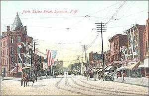
The main street in Little Italy is North Salina Street was originally a German neighborhood. The Italians all but supplanted the Germans and now have their own business district along North State and North Salina Streets.[2]
The Ziegler House was listed on the National Register of Historic Places in 1997.[3]
Electric rail
In 1909, the "North Side Common Center" had become one of the busiest sections of the Syracuse business district since the operation of the Oneida Railway, the Syracuse and South Bay Railway and Syracuse, Lake Shore and Northern Railroad lines that ran through the blocks bounded by Noxon, North Salina, West Genesee and North Clinton streets.[4]
The local merchants predicted that with the completion of the Syracuse, Lake Shore and Northern Railroad to Oswego, New York and Rochester, New York as well as the Syracuse and Eastern Railroad from Port Byron, their "trade will be nearly doubled by the resulting transient trade within the year."[4]
City Parks
Washington Square
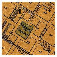

In 1797, the Village of Salina acquired the plot now known as Washington Square. It was used as a cemetery until it was dedicated for park purposes in 1839. In 1847, the village became a part of the City of Syracuse. By 1860, the park was intersected by Center Street (LeMoyne Avenue) and Park Street, and surrounded by Carbon Street to the north, Wolf Street to the west, Central City rail line to the south and Bear Street to the east.
Washington Square Park is also home to the LeMoyne Drinking Fountain monument. The park is 3.2 acres and is located Avenue.
Eckel Monument
The Philip Eckel Monument was dedicated on August 22, 1900 at the intersection of North Salina, Butternut and State Streets in the middle of the German community. Eckel was a German immigrant, Civil War veteran and the fire chief of Syracuse at the time of his death on June 1, 1886. He was "thrown from a horse-drawn vehicle while on his way to fight a blaze."[5]

Schiller Park
On May 27, 1901, the Syracuse Common Council approved spending $25,000 to buy 23.5 acres of Round Top Park (drumlin) for park purposes. The land was originally the home of St. Cecilia's Cemetery. This site was a forested hilltop with an open clearing around a drumlin-like landform believed to be an ancient burial ground. Bodies that had been buried in St. Cecelia's Cemetery were removed in 1901 to prepare the site for use as a park. The site was also used during the French and Indian War for a lookout. The name was changed from Round Top Park to Schiller Park on July 3, 1905.[6]

Additional land was added in 1907 and the tract was formally laid out as a park in 1910.
David Campbell, former head gardener for the Thornden estate and at the time Superintendent of Parks for the city, designed Schiller Park in 1911, influenced by the prevailing Arts & Crafts Movement. The loop drives in Schiller Park complemented and emphasized the park's drumlin landform.
In early September 1915, work was begun on the new Schiller Park bathing, skating and Comfort Pavilion to be built at a cost of $13,000. The building was designed by the architectural firm of Merrick & Randall and approved by the Syracuse Park commission.[7]

The new pavilion covered a plot of rectangular ground, northeast of the swimming pool. The structure was 71 feet (22 m) long by 21 feet (6.4 m) wide. The first floor was divided into separate locker rooms, shower rooms and accessory quarters for men and women. The top floor was open "so as to become practically a balcony," that could be enclosed in winter, when the building was used as a shelter for ice-patrons of the athletic-ground rink.[7]
Unique to the park, honoring the German-American neighborhood population, is the Goethe–Schiller Monument. It was erected in 1911 by the German-American community. The monument honors Johann Wolfgang von Goethe (1749-1832) and Friedrich Schiller (1759-1805), regarded as Germany’s greatest poets/playwrights. The Syracuse monument is modeled on the 1857 Goethe–Schiller Monument in Weimar, which has become a national landmark in Germany.[8]
Some of the park's built-in elements retain vestiges of the Arts and Crafts Movement. At the park's highest point, one can observe a panoramic view of downtown Syracuse.[9]
Schiller Park today is over 37 acres in size and has nearly 3 miles of roads. The loop drives were closed to vehicular traffic in 1976. A significant stand of oaks still survives along the slopes of the drumlin from the early days of the park. The park is bounded by Oak Street, Rugby Road, Farmer Street, and Whitwell Drive.[9]
Today Schiller Park is home to several athletic fields and courts including a softball diamond and a hardball diamond, six tennis courts, two handball courts and a basketball court. The park also has a pool that is 165 feet (50 m) long by 75 feet (23 m) wide with ten lanes. The pool has a capacity of 485 bathers. Water depth ranges from 3 feet (0.91 m) to 12 feet (3.7 m). The pool also has a children's spray fountain.[9]
Schlosser Park
Schlosser Park was named after Charles Schlosser, a wagonmaker, who came to Syracuse from St. Julian, Germany in the Mosel River area with his brothers Jacob, Henry, Peter, Nicholas and Ludwig (Louis) in the mid-1800s. The German immigrants helped build up the Northside of Syracuse. Charles Schlosser donated a small park in front of his wagonmaking business which is still named in his honor.[10]
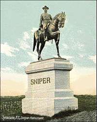
The Sniper Monument is an equestrian statue and depicts Civil War veteran Gustavus Sniper, a German immigrant, for his contributions during the Civil War. It is located in Schlosser Park on North Salina Street near downtown.[11]
In February 1901, the Sons of Veterans give plans for the Sniper Monument to two contractors for bids. Schlosser Park is bounded by North Salina Street, North State Street and Laurel Street.[11]
Revitalization efforts
Like many rust belt cities, Syracuse has experienced population loss as residents move to the suburbs or pursue opportunities in other regions. This disinvestment in infrastructure and services is magnified in many urban neighborhoods. While the Northside has suffered in this vein, it remains a place recognized for its past and current assets, and its potential for sustainable, local development.
Multiple neighborhood residents, businesses, and organizations have been active in revitalization efforts for the neighborhood. These efforts have included garnering support and opportunity for local artists,[12] initiatives to improve the building stock, and improvements in housing options, to name a few.[13]
St. Joseph’s Hospital, the neighborhood’s largest economic institution, is furthering the positive growth and development of the Northside. In 2009, the hospital broke ground on a $220 Million expansion.[14]
Notable sites
- Open Hand Theater
- North Salina Street Historic District
- Little Italy Business District
External links
References
- ↑ "Central New York sure loves to have a good time". The Post-Standard, 2009. Retrieved October 26, 2010.
- ↑ "New York, Syracuse". Atlantis, 2010. Retrieved November 3, 2010.
- ↑ National Park Service (2010-07-09). "National Register Information System". National Register of Historic Places. National Park Service.
- 1 2 "Transient Trade Keeps North Siders Busy". Syracuse Herald. Syracuse, New York. June 4, 1909.
- ↑ Stone, Michelle. "Syracuse Postcards". Rootsweb, April 2006. Retrieved March 13, 2011.
- ↑ "Round Top is Schiller Park". The Post-Standard. Syracuse, New York. July 4, 1905.
- 1 2 "Start Work on Comfort Pavilion". Syracuse Herald. Syracuse, New York. August 29, 1915.
- ↑ "Monuments". Rootsweb, 2010. Retrieved October 26, 2010.
- 1 2 3 "Schiller Park". City of Syracuse - Department of Parks, Recreation & Youth Programs, 2008. Retrieved October 26, 2010.
- ↑ Schlosser, Judy. "Schlosser Family Tree". Comcast, 2010. Retrieved October 26, 2010.
- 1 2 "Schlosser Park Rose Garden". Waymarking, 2010. Retrieved October 26, 2010.
- ↑ Guidice, Toni. "Art project puts huge photos around Syracuse's North Side". Syracuse Online LLC., 2010. Retrieved October 26, 2010.
- ↑ Carlic, Steve. "St. Joe's To Unveil North Side Housing". The Post-Standard, January 14, 2008. Retrieved October 26, 2010.
- ↑ "St. Joe's News Archive". St. Joseph's Hospital, 2009. Retrieved October 26, 2010.
Coordinates: 43°03′54″N 76°08′42″W / 43.065°N 76.145°W