Northern Busway, Brisbane
| Northern Busway | |||||||||||||||||||||||||||||||||||||||||||||||||||||||||||||||||||||||||||||||||||||||||||||||||||||||||||||||||||||||||||||||||||||||||||||||||||||||||||||||||||||||||||||||||||||||||||||||||||||||||||||||||||||||||||||||||||||||||||||||||||||||||||||||||||||||||||||||||||||||||||
|---|---|---|---|---|---|---|---|---|---|---|---|---|---|---|---|---|---|---|---|---|---|---|---|---|---|---|---|---|---|---|---|---|---|---|---|---|---|---|---|---|---|---|---|---|---|---|---|---|---|---|---|---|---|---|---|---|---|---|---|---|---|---|---|---|---|---|---|---|---|---|---|---|---|---|---|---|---|---|---|---|---|---|---|---|---|---|---|---|---|---|---|---|---|---|---|---|---|---|---|---|---|---|---|---|---|---|---|---|---|---|---|---|---|---|---|---|---|---|---|---|---|---|---|---|---|---|---|---|---|---|---|---|---|---|---|---|---|---|---|---|---|---|---|---|---|---|---|---|---|---|---|---|---|---|---|---|---|---|---|---|---|---|---|---|---|---|---|---|---|---|---|---|---|---|---|---|---|---|---|---|---|---|---|---|---|---|---|---|---|---|---|---|---|---|---|---|---|---|---|---|---|---|---|---|---|---|---|---|---|---|---|---|---|---|---|---|---|---|---|---|---|---|---|---|---|---|---|---|---|---|---|---|---|---|---|---|---|---|---|---|---|---|---|---|---|---|---|---|---|---|---|---|---|---|---|---|---|---|---|---|---|---|---|---|---|---|---|---|---|---|---|---|---|---|---|---|---|---|---|---|---|---|---|
| Overview | |||||||||||||||||||||||||||||||||||||||||||||||||||||||||||||||||||||||||||||||||||||||||||||||||||||||||||||||||||||||||||||||||||||||||||||||||||||||||||||||||||||||||||||||||||||||||||||||||||||||||||||||||||||||||||||||||||||||||||||||||||||||||||||||||||||||||||||||||||||||||||
| System | TransLink | ||||||||||||||||||||||||||||||||||||||||||||||||||||||||||||||||||||||||||||||||||||||||||||||||||||||||||||||||||||||||||||||||||||||||||||||||||||||||||||||||||||||||||||||||||||||||||||||||||||||||||||||||||||||||||||||||||||||||||||||||||||||||||||||||||||||||||||||||||||||||||
| Status | In service | ||||||||||||||||||||||||||||||||||||||||||||||||||||||||||||||||||||||||||||||||||||||||||||||||||||||||||||||||||||||||||||||||||||||||||||||||||||||||||||||||||||||||||||||||||||||||||||||||||||||||||||||||||||||||||||||||||||||||||||||||||||||||||||||||||||||||||||||||||||||||||
| Began service | February 2004 | ||||||||||||||||||||||||||||||||||||||||||||||||||||||||||||||||||||||||||||||||||||||||||||||||||||||||||||||||||||||||||||||||||||||||||||||||||||||||||||||||||||||||||||||||||||||||||||||||||||||||||||||||||||||||||||||||||||||||||||||||||||||||||||||||||||||||||||||||||||||||||
| Route | |||||||||||||||||||||||||||||||||||||||||||||||||||||||||||||||||||||||||||||||||||||||||||||||||||||||||||||||||||||||||||||||||||||||||||||||||||||||||||||||||||||||||||||||||||||||||||||||||||||||||||||||||||||||||||||||||||||||||||||||||||||||||||||||||||||||||||||||||||||||||||
| Start | South East Busway | ||||||||||||||||||||||||||||||||||||||||||||||||||||||||||||||||||||||||||||||||||||||||||||||||||||||||||||||||||||||||||||||||||||||||||||||||||||||||||||||||||||||||||||||||||||||||||||||||||||||||||||||||||||||||||||||||||||||||||||||||||||||||||||||||||||||||||||||||||||||||||
| Via | main city train lines, Exhibition railway line, Victoria Park Golf Complex | ||||||||||||||||||||||||||||||||||||||||||||||||||||||||||||||||||||||||||||||||||||||||||||||||||||||||||||||||||||||||||||||||||||||||||||||||||||||||||||||||||||||||||||||||||||||||||||||||||||||||||||||||||||||||||||||||||||||||||||||||||||||||||||||||||||||||||||||||||||||||||
| End | RBWH precinct | ||||||||||||||||||||||||||||||||||||||||||||||||||||||||||||||||||||||||||||||||||||||||||||||||||||||||||||||||||||||||||||||||||||||||||||||||||||||||||||||||||||||||||||||||||||||||||||||||||||||||||||||||||||||||||||||||||||||||||||||||||||||||||||||||||||||||||||||||||||||||||
| Stations | 13 | ||||||||||||||||||||||||||||||||||||||||||||||||||||||||||||||||||||||||||||||||||||||||||||||||||||||||||||||||||||||||||||||||||||||||||||||||||||||||||||||||||||||||||||||||||||||||||||||||||||||||||||||||||||||||||||||||||||||||||||||||||||||||||||||||||||||||||||||||||||||||||
| |||||||||||||||||||||||||||||||||||||||||||||||||||||||||||||||||||||||||||||||||||||||||||||||||||||||||||||||||||||||||||||||||||||||||||||||||||||||||||||||||||||||||||||||||||||||||||||||||||||||||||||||||||||||||||||||||||||||||||||||||||||||||||||||||||||||||||||||||||||||||||
The Northern Busway is a bus-only road in Brisbane, Queensland. The busway allows buses to travel north/south through the Brisbane City without encountering car traffic. The first section of the Northern Busway opened in February 2004 and had one station, the QUT Kelvin Grove. station. Later the Normanby and Herston stations opened.[1][2]
The Northern Busway extension opened in stages with the Herston to Windsor section opening in August 2009,[3] and the Windsor and Kedron section opening in June 2012.[4]
The Northern Busway starts at the end of the South East Busway. It then proceeds north-west to the King George Square Bus Station. The Northern Busway then surfaces near Roma Street railway station and follows the alignment of the main city train lines. The busway then continues north alongside the Exhibition railway line and then north-east through the Victoria Park Golf Complex, with stations adjacent to the Normanby Fiveways, the QUT campus at Kelvin Grove and the Royal Children's Hospital in the suburb of Herston. The busway then turns left and on to a bridge structure alongside the RBWH precinct over Butterfield Street. In the future, the busway will continue to Bracken Ridge, via Windsor, Lutwyche, Kedron, Chermside and Aspley. At Windsor, it integrates with the Airport Link project, a new underground road to the Brisbane Airport.[5]
History
The first section of the Northern Busway, from the intersection of Roma Street to Herston, opened in February 2004 with only one station, QUT Kelvin Grove.[6] In December 2005, two new stations, Normanby and RCH Herston, were opened on the first section of the Northern Busway.[1][2] In May 2007, the Queensland Government gives the green light for the Airport Link project, which includes an extension for the Northern Busway. This extension will take the Northern Busway to Bracken Ridge via Windsor, Lutwyche, Kedron, Chermside and Aspley.[7]
The second section of the Northern Busway, also known as the Inner Northern Busway, officially opened to buses on May 2008.[8] This section connects the first section of the Northern Busway to the South East Busway with stations at King George Square and Roma Street. To make room for the Inner Northern Busway at Roma Street one rail platform was removed.[9][10] In August 2009, the first stage of the Northern Busway extension, Herston to Windsor, opened for buses.[3]
Route
King George Square to RBWH (Inner Northern Busway) Section
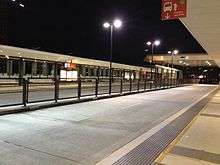
The Northern Busway starts in a tunnel underneath Albert Street in the city centre adjacent to the Queen Street bus station, previously the terminus of the South East Busway. Many northbound services using the Northern Busway originate at the Cultural Centre busway station on the South East Busway. It then proceeds north-west to the King George Square busway station, a large interchange with several stops on each of its two underground platforms. The Northern Busway then surfaces near Roma Street railway station and follows the alignment of the main city train lines. Roma Street busway station is adjacent to the train platforms and is on the same level. Platform 2 is shared by both trains and buses, although the only train to currently use Platform 2 is NSW TrainLink's daily XPT service to Sydney Central.
The busway then continues north alongside the Exhibition railway line and then north-east through the Victoria Park Golf Complex, with stations adjacent to the Normanby Fiveways, the QUT campus at Kelvin Grove and the Royal Children's Hospital in the suburb of Herston. The busway then turns left and on to a bridge structure alongside the RBWH precinct over Butterfield Street.
In the future, the busway will continue to Bracken Ridge, via Windsor, Lutwyche, Kedron, Chermside and Aspley. At Kedron, it will be integrated with the Airport Link project, a new underground road to Brisbane Airport.[5]
Windsor to Kedron Section
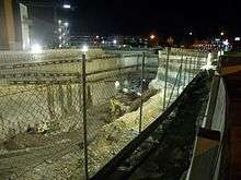
The Windsor to Kedron Section was completed in June 2012.[11] The route rejoins Lutwyche Road after crossing Enoggera Creek. The route travels via bus lanes and local bus stops until it reaches Truro Street, when it enters into a dedicated underground busway tunnel. After passing through Lutwyche Busway Station and Kedron Brook Busway Station and crossing Kedron Brook, the route rejoins Lutwyche Road at Stafford Road (Southbound/Inbound) and Sadlier Street (Northbound/Outbound).[12]
The section was opened to a public on 16 June 2012 and the bus transport commenced on 18 June 2012.[4]
Kedron to Bracken Ridge Section
The Kedron to Bracken Ridge section of the busway is currently under planning, with completion anticipated by 2026.[13] The Queensland Government has released a series of draft alignments in order to identify the corridor for preservation, however no final route has been selected.[14]
The conservative LNP Queensland Government elected in March 2012 has indicated an intention to revisit the alignment for this project.[15] Their primary points of departure from the policy of the previous government appear to be a preference not to protect for the long-term high-cost full busway option previously being explored and an election commitment not to take the busway to The Prince Charles Hospital. These changes are predicated on the perceived high expense and impact of the previously published preferred options. The government's current stated preference is for bus or transit lane level priority along the highly congested Gympie Road corridor.
See also
References
- 1 2 "Beattie opens new $135 million busway". Retrieved 31 March 2010.
- 1 2 "Two New Stations Help Make Busway The Smart Way To Travel". Retrieved 31 March 2010.
- 1 2 "More than half a billion dollars worth of busway to open for business". Retrieved 31 March 2010.
- 1 2 "Northern Busway sneak peek". Campbell Newman. Department of the Premier and Cabinet. 13 June 2012. Retrieved 6 July 2012.
- 1 2 "Translink Northern Busway". Retrieved 31 March 2010.
- ↑ Odgers, Rosemary; Heywood, Lachlan (23 February 2004). "Busway to reduce commuting times". The Courier-Mail (1 - First with the news ed.). p. 7.
- ↑ "Airport Link and Northern Busway get the green light". Retrieved 31 March 2010.
- ↑ "Commuters save travel time as INB officially opens". Retrieved 31 March 2010.
- ↑ "Premier inspects Inner Northern Busway progress". Retrieved 31 March 2010.
- ↑ "Roma Street to become hub for bus and rail". Retrieved 31 March 2010.
- ↑ "Windsor to Kedron". Translink. Retrieved 9 September 2011.
- ↑ "Planning bus services for the Northern Busway (Windsor to Kedron) Fact Sheet March 2010" (PDF). Translink. Retrieved 9 September 2011.
- ↑ "Northern Busway". Translink. Retrieved 9 September 2011.
- ↑ "Northern Busway: Kedron to Bracken Ridge". Queensland Department of Transport and Main Roads. Retrieved 9 September 2011.
- ↑ "Courier Mail Northern Busway may be Scrapped". Courier Mail. Retrieved 30 May 2016.
External links
| Wikimedia Commons has media related to Northern Busway, Brisbane. |