Northbourne Avenue
| Northbourne Avenue Australian Capital Territory | |
|---|---|
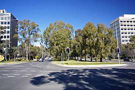 | |
| Looking south along Northbourne Avenue, at the intersection of Macarthur Avenue (west) / Wakefield Avenue (east) | |
| Coordinates | 35°15′39″S 149°07′55″E / 35.2608°S 149.132°E |
| General information | |
| Type | Highway |
| Length | 4.52 km (2.8 mi) |
| Gazetted | 20 September 1928 |
| Route number(s) |
|
| Former route number |
|
| Tourist routes |
|
| Major junctions | |
| South end |
|
| |
| North end |
|
| Location(s) | |
| Major suburbs | City, Braddon, Turner, Dickson, Lyneham, Downer |
| Highway system | |
|
Highways in Australia National Highway • Freeways in Australia Road infrastructure in Canberra | |
| |
Northbourne Avenue is a major road in Canberra, Australia. It extends from City Hill in the south to the Federal Highway in the north.
It is a north-south running road which has three lanes for motorised traffic, and one lane for bicycles running in each direction, with a large median strip with rows of trees. The speed limit is 60 km/h, with an 80 km/h speed limit north of the intersection with Mouat Street and Antill Street. These speed limits are strictly enforced with multiple fixed red light/speed cameras in the 60 km/h zone and mobile speed cameras being permitted to operate along the entire length of the road.
Northbourne Avenue is the dividing line between the suburbs of Turner and Lyneham on the west, with the suburbs of Braddon, Dickson and Downer on the east.

Many ACTION buses travelling between City and Dickson, Gungahlin or Belconnen use the road, which has many bus stops along it. A project plan to install a light rail network, called Capital Metro along the median strip is under construction.
See also
![]() Australian Roads portal
Australian Roads portal
External links
![]() Media related to Northbourne Avenue, Canberra at Wikimedia Commons
Media related to Northbourne Avenue, Canberra at Wikimedia Commons
| Controlled-access roads: | ||
|---|---|---|
| Limited-access roads: |
| |
| Major interchanges: | ||
| Proposed or cancelled |
| |
*Partially limited-access ^Partially controlled-access roadway under construction | ||