North Sumatra
| North Sumatera | |||||||||
|---|---|---|---|---|---|---|---|---|---|
| Province | |||||||||
| Sumatera Utara | |||||||||
| Other transcription(s) | |||||||||
| • Jawi | سوماتيرا اوتارا | ||||||||
| • Chinese | 北蘇門答臘 / 北苏门答腊 | ||||||||
| • Nias | Sumatera Röpa | ||||||||
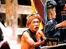
From top, left to right : Lake Toba, Mount Sinabung, Bahal temple, Nias people war dance, Puppeteers of Sigale Gale, The Malays's Serampang 12 dance, Tangkahan river, Mursala Island, and panoramic view of Medan | |||||||||
| |||||||||
| Motto: Tekun Berkarya, Hidup Sejahtera, Mulia Berbudaya ("Work diligently, live prosperously, noble in culture") | |||||||||
 Location of North Sumatera in Indonesia | |||||||||
| Coordinates: 2°00′N 99°00′E / 2.000°N 99.000°ECoordinates: 2°00′N 99°00′E / 2.000°N 99.000°E | |||||||||
| Country |
| ||||||||
| Established | April 15, 1948 | ||||||||
| Capital |
| ||||||||
| Government | |||||||||
| • Body | North Sumatera Regional Government | ||||||||
| • Governor | Tengku Erry Nuradi (acting) (Golkar) | ||||||||
| • Vice Governor | Vacant | ||||||||
| Area | |||||||||
| • Total | 72,981.23 km2 (28,178.21 sq mi) | ||||||||
| Area rank | 8th | ||||||||
| Highest elevation | 2,460 m (8,070 ft) | ||||||||
| Population (2014) | |||||||||
| • Total | 13,527,937 | ||||||||
| • Rank | 4th | ||||||||
| • Density | 190/km2 (480/sq mi) | ||||||||
| • Density rank | 11th | ||||||||
| Demonym(s) |
North Sumateran Warga Sumatera Utara (id) | ||||||||
| Demographics | |||||||||
| • Ethnic groups |
Batak (41.95%) (Karo, Pakpak, Simalungun, Batak Toba, Angkola, Mandailing) Javanese (32.62%) Malay (4.92%) Chinese (3.07) Nias (6.36%) Minangkabau (2.66%) Acehnese (1.27%) other (7.45%)[1] | ||||||||
| • Religion | Islam (66.09%), Protestantism (27.03), Catholicism (3.97%), Buddhism (2.34%), Confucianism (0.01%), Hinduism (0.11%) | ||||||||
| • Languages | Indonesian, Malay, Karo, Pakpak, Simalungun, Batak Toba, Angkola, Mandailing, Javanese, Hokkien, Hakka, Teochew, Yue, Nias, Minangkabau, Aceh | ||||||||
| Time zone | Indonesia Western Time (UTC+7) | ||||||||
| Postcodes | 20xxx, 21xxx, 22xxx | ||||||||
| Area codes | (62)6xx | ||||||||
| ISO 3166 code | ID-SU | ||||||||
| Vehicle sign |
BB (Western region) BK (Eastern region) | ||||||||
| GRP per capita | US$ 3,204 | ||||||||
| GRP rank | 13th | ||||||||
| HDI |
| ||||||||
| HDI rank | 10th | ||||||||
| Largest city by area | Gunungsitoli - 280.78 square kilometres (108.41 sq mi) | ||||||||
| Largest city by population | Medan - (2,210,624 - 2016) | ||||||||
| Largest regency by area | Langkat Regency - 6,262.00 square kilometres (2,417.77 sq mi) | ||||||||
| Largest regency by population | Deli Serdang Regency - (2,029,308 - 2016) | ||||||||
| Website | Government official site | ||||||||


North Sumatra (Indonesian: Sumatera Utara, is a province of Indonesia. It is located on the island of Sumatra, and its capital is Medan. North Sumatra is fourth most populous province in Indonesia after West Java, East Java and Central Java and the most populous Indonesian province outside Java, with over 13,5 million inhabitants in 2014.[2]
Geography and population
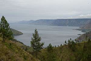
The province of North Sumatra stretches across the island of Sumatra between the Indian Ocean and the Strait Malacca. It borders Aceh province on the northwest and Riau and West Sumatra provinces in the southeast. It has an area of 72,981 km². The province contains a broad, low plain along the Strait of Malacca on which the provincial capital, Medan, is located. In the south and west, the land rises to the mountain range that runs the length of Sumatra; the mountains here are dominated by Lake Toba, formed from the caldera of an ancient volcano. Several large islands in the Indian Ocean off the west coast of Sumatra are currently part of North Sumatra, most notably Nias Island and the Batu Islands.
North Sumatra recorded a population of 12,985,075 in the 2010 national census, making the 4th most populous province in Indonesia, with a sex ratio of 99.59 men per 100 women.[3] The latest estimate (for January 2014) is 13,527,937.[2]
| Historical population | ||
|---|---|---|
| Year | Pop. | ±% |
| 1971 | 6,621,831 | — |
| 1980 | 8,360,894 | +26.3% |
| 1990 | 10,256,027 | +22.7% |
| 1995 | 11,114,667 | +8.4% |
| 2000 | 11,649,655 | +4.8% |
| 2010 | 12,982,204 | +11.4% |
| 2014 | 13,527,937 | +4.2% |
| Source: Badan Pusat Statistik 2010 | ||
Demographics
North Sumatra is a multi-ethnic province. The Batak, Nias, and the Malay peoples are regarded as the native people of this province. The east coast of North Sumatra is generally inhabited by Malays and Chinese. The Javanese mostly reside in Deli Serdang Regency, including Medan, while the West coast of province is mainly inhabited the Pakpak, Mandailing and Minangkabau peoples. The central region around Lake Toba, is predominantly inhabited by the Batak peoples. The Nias people reside mostly in Nias Island and the surrounding islands. With the opening of tobacco plantations in East Sumatra during the Dutch East Indies era, the colonial government employed many contract laborers for plantations. The newcomers were mostly Javanese and Chinese, and included a small Indian community. The distribution of the tribes, clans and ethnicities in North Sumatra is as follows:
- Malay : Medan, Stabat, Binjai, Lubuk Pakam, Tebing Tinggi, Tanjung Balai, Kisaran, Rantau Prapat, and other towns and villages across east coast of North Sumatra
- Batak Toba : Medan, Pematang Siantar, Balige, Pangururan, Dolok Sanggul, Siborong-Borong, Tarutung, and other towns or villages surrounding Lake Toba and central region of North Sumatra
- ""Simalungun"" : Pematang Siantar, Medan, Balige, Samosir Island, Kisaran, Binjai, Lima Puluh, Parapat, Kabanjahe and other towns or villages in North Sumatera.
- Karo : Medan, Binjai, Berastagi, Kabanjahe, Tongging, Tigapanah, and other towns or villages around Karo Regency
- Mandailing : Medan, Sibolga, Padang Sidempuan, Sipirok, Panyabungan, Kotanopan, Natal, Barus, Pinangsori and other towns or villages in south region of North Sumatra.
- "" Angkola"" : Sipirok, Medan, Padang Sidempuan, Gunung Tua, Padang Lawas regency, Rantau Prapat, Pangaribuan, Sibolga, and other towns or villages in south region of North Sumatera.
- Nias : Gunungsitoli, Bawolato, Lagundri and other towns and villages in Nias Island
- Pakpak : Sidikalang, Sumbul, Tigalingga and other towns and villages in Dairi Regency
- Javanese : Mostly resided in Medan, Tanjung Morawa, Lubuk Pakam, Percut Sei Tuan and other towns in Deli Serdang Regency
- Chinese : Medan, Lubuk Pakam, Tanjung Balai, Rantau Prapat, Perbaungan, Kisaran and other towns and village in east coast of North Sumatra.
- Minangkabau : mostly in Medan, Asahan, Batahan, Natal, Padang Sidempuan, Panyabungan, Sibolga, Barus and other towns and village in west coast of North Sumatra.
- Acehnese : Medan, Pangkalan Susu, Pangkalan Brandan and other towns and village in Langkat Regency
Administrative divisions

North Sumatra is currently subdivided into 25 regencies and 8 autonomous cities, listed below with their (provisional) populations at the 2010 Census and according to the latest (2014) estimates. With proposals under consideration to create three additional provinces from parts of the present North Sumatra, these are grouped below according to the putative new province in which they are situated:
Nias Island Region
| Name | Area (km2) | Population Census 2010[4] | Population Estimate January 2014[2] | Capital |
|---|---|---|---|---|
| Gunungsitoli City | 230.80 | 125,566 | 131,507 | Gunungsitoli |
| Nias Regency | 3,495.39 | 132,329 | 136,900 | Gunungsitoli |
| North Nias Regency (Nias Utara) | 1,202.78 | 127,530 | 132,593 | Lotu |
| South Nias Regency (Nias Selatan) | 1,625.91 | 289,876 | 301,886 | Teluk Dalam |
| West Nias Regency (Nias Barat) | # | 81,461 | 85,246 | Lahomi |
- # the area of West Nias Regency is included in the figure for Nias Regency.
Southeast Sumatra Region
| Name | Area (km2) | Population Census 2010 | Population Estimate January 2014[2] | Capital |
|---|---|---|---|---|
| Padang Sidempuan City | 114.65 | 191,554 | 199,582 | Padang Sidempuan |
| Mandailing Natal Regency | 6,620.70 | 403,894 | 421,968 | Panyabungan |
| North Padang Lawas Regency (Padang Lawas Utara) | 3,918.05 | 223,049 | 232,928 | Gunung Tua |
| Padang Lawas Regency | 3,892.74 | 223,480 | 234,728 | Sibuhuan |
| South Tapanuli Regency (Tapanuli Selatan) | 4,352.86 | 264,108 | 274,905 | Sipirok |
Tapanuli Region
| Name | Area (km2) | Population Census 2010 | Population Estimate January 2014[2] | Capital |
|---|---|---|---|---|
| Sibolga City | 10.77 | 84,444 | 88,032 | Sibolga |
| Central Tapanuli Regency (Tapanuli Tengah) | 2,158.00 | 310,962 | 324,315 | Pandan |
| Humbang Hasundutan Regency | 2,297.20 | 171,687 | 178,866 | Dolok Sanggul |
| North Tapanuli Regency (Tapanuli Utara) | 3,764.65 | 278,897 | 290,996 | Tarutung |
| Samosir Regency | 2,433.50 | 111,650 | 124,683 | Pangururan |
| Toba Samosir Regency | 2,352.35 | 172,933 | 180,407 | Balige |
East Sumatra Region
| Name | Area (km2) | Population Census 2010 | Population Estimate January 2014[2] | Capital |
|---|---|---|---|---|
| Binjai City | 90.24 | 246,010 | 256,502 | Binjai |
| Medan City | 265.10 | 2,109,339 | 2,185,789 | Medan |
| Pematang Siantar City | 79.87 | 234,885 | 244,564 | Pematang Siantar |
| Tanjung Balai City | * | 154,426 | 160,941 | Tanjung Balai |
| Tebing Tinggi City | 38.44 | 145,180 | 151,354 | Tebing Tinggi |
| Asahan Regency | 3,675.79 | 667,563 | 696,364 | Kisaran |
| Batubara Regency | 904.96 | 374,535 | 391,686 | Limapuluh |
| Dairi Regency | 1,927.80 | 269,848 | 281,405 | Sidikalang |
| Deli Serdang Regency | 2,486.14 | 1,789,243 | 1,865,695 | Lubukpakam |
| Karo Regency | 2,127.25 | 350,479 | 365,713 | Kabanjahe |
| Labuhan Batu Regency | 9,223.18 | 414,417 | 432,560 | Rantau Prapat |
| Langkat Regency | 6,263.29 | 966,133 | 1,008,207 | Stabat |
| North Labuhan Batu Regency (Labuhan Batu Utara) | # | 331,660 | 344,603 | Aek Kanopan |
| Pakpak Bharat Regency | 1,218.30 | 40,481 | 42,208 | Salak |
| Serdang Bedagai Regency | 1,913.33 | 592,922 | 619,367 | Sei Rampah |
| Simalungun Regency | 4,386.60 | 818,104 | 852,095 | Raya |
| South Labuhan Batu Regency (Labuhan Batu Selatan) | # | 277,549 | 289,346 | Kota Pinang |
- Notes
- * the area of Tanjung Balai city is included in the figure for Asahan Regency, from which it was carved out in 2007.
- # the areas of North Labuhan Batu Regency and South Labuhan Batu Regency are included in the figure for Labuhan Batu Regency, from which they were carved out in 2007.
Agriculture and Economy
Sumatra Mandheling and Sumatra Lintong coffee beans are grown in North Sumatra and largely exported to the United States. Mandheling is named after the similarly spelt Mandailing people located in North Sumatra, Indonesia. The name is the result of a misunderstanding by the first foreign purchaser of the variety, and no coffee is actually produced in the "Mandailing region". Lintong on the other hand, is named after the Lintong district, also located in North Sumatra.
Sei Mangkei Industrial Area
Sei Mangkei Industrial Area, also known as Sei Mangkei - Integrated Sustainable Palm Oil Cluster (SM-ISPOIC), is located in Simalungun Regency and was formally opened on 12 June 2010. Four companies have joined in this area, with investment costs totalling up to Rp1.5 trillion ($176 million).[5][6] In April 2011, three other companies also joined in the Sei Mangkei area. They are Procter & Gamble Co for making CPO derivatives of cosmetic raw materials, Ferrostaal AG and Fratelli Gianazza SpA.
Tourism

- Lake Toba is the largest volcanic lake in the world. Located in the centre of North Sumatra, the lake can be reached via Parapat (Simalungun regency), Tongging (Karo regency), and Balige (Toba Samosir regency).
- Samosir Island is a volcanic island in middle of Lake Toba, It is a popular tourist destination due to its exotic Batak history and the vistas it offers. The tourist resorts are concentrated in the Tuktuk, Tomok, Simanindo, and Pangururan areas.
- Nias Island is an island off the western coast of Sumatra. Nias is an internationally popular surfing destination. The best known surfing area is Sorake Bay, close to the town of Teluk Dalam, on the southern tip. This is enclosed by the beaches of Lagundri and Sorake. Tourists can visit the island by plane from Medan, or by ferry from Sibolga.
- Berastagi is a small highland town located 63 kilometers to the south of Medan, and is a popular weekend destination for city dwellers.
- Lumbini Natural Park is a Buddhist theravada-style temple that is similar to Shwedagon Pagoda in Myanmar.
- Dua Warna Waterfall is a two-coloured waterfall located on Sibolangit.
- Taman Simalem Resort is a hotel and resort located near Tongging, with excellent views of Lake Toba.
- Berhala Island is a 2,5 hectares island located in the Malaka Strait near the boundary of Indonesia and Malaysia. It is a popular place for snorkeling and watching turtle nesting. Visitors can reach the island via boat from Sergei in the Serdang Bedagai regency.
- Sipisopiso, one of the highest waterfalls in Indonesia, is located near Tongging in Karo regency.
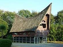
- Bahal temple, a ancient Buddhist monastery located on Padang Bolak, Padang Lawas Regency, around 3 hours journey with car from Padangsidempuan. The temple believes constructed between the 11th to 13th century CE.
Transportation
Airports
The modern Kuala Namu International Airport was opened on July 25, 2013 and is located almost 40 kilometers from Medan. The airport replaces the old Polonia International Airport.[7] It serves flights to several Indonesian and Malaysian cities, along with flights to Singapore, Thailand, Sri Lanka and Saudi Arabia. Flights to India and China are also planned. In passenger numbers, Kuala Namu is the fifth largest airport in Indonesia.
Polonia International Airport (Indonesian: Bandar Udara Internasional Polonia) (IATA: MES, ICAO: WIMM) (popularly Polonia Airport, as in Indonesia, Bandara Polonia) is located about 5 km from the Central Business District of Medan. It is the first international airport in Medan, although the airport is under air force authority. Polonia airport is the site of several crashes, is inappropriately located in the center of the city of Medan, has a difficult takeoff path and a short runway.
Seaports
North Sumatra has an international seaport at Belawan, near Medan and is now preparing to have a new seaport at Kuala Tanjung, in Batubara Regency, for about Rp.1 trillion ($114 million) budget.[8]
References
- ↑ Indonesia's Population: Ethnicity and Religion in a Changing Political Landscape. Institute of Southeast Asian Studies. 2010.
- 1 2 3 4 5 6 http://www.depkes.go.id/downloads/Penduduk%20Kab%20Kota%20Umur%20Tunggal%202014.pdf Estimasi Penduduk Menurut Umur Tunggal Dan Jenis Kelamin 2014 Kementerian Kesehatan
- ↑ Account Suspended
- ↑ Biro Pusat Statistik, Jakarta, 2011.
- ↑ Four Firms to Invest Rp1.5 Trln in Sei Mangkei Industrial Area, Sumatera
- ↑ Jurnas.com
- ↑ "Roda Empat Disediakan Menuju Bandara Kuala Namu". July 23, 2013.
- ↑ http://waspada.co.id/index.php?option=com_content&view=article&id=181542:n-sumatra-to-have-new-seaport&catid=30:english-news&Itemid=101
External links
| Wikimedia Commons has media related to North Sumatra. |
Template:Indonesia