North Springfield, Virginia
| North Springfield, Virginia | |
|---|---|
| Census-designated place | |
|
Houses in North Springfield, October, 2016 | |
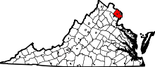
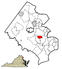 Location of North Springfield in Fairfax County, Virginia | |
 North Springfield, Virginia  North Springfield, Virginia  North Springfield, Virginia Location of North Springfield in Fairfax County, Virginia | |
| Coordinates: 38°48′14″N 77°12′30″W / 38.80389°N 77.20833°WCoordinates: 38°48′14″N 77°12′30″W / 38.80389°N 77.20833°W | |
| Country | United States |
| State | Virginia |
| County | Fairfax |
| Area | |
| • Total | 1.55 sq mi (4.02 km2) |
| • Land | 1.54 sq mi (3.99 km2) |
| • Water | 0.01 sq mi (0.03 km2) |
| Elevation | 302 ft (92 m) |
| Population (2010) | |
| • Total | 7,274 |
| • Density | 4,719/sq mi (1,821.9/km2) |
| Time zone | Eastern (EST) (UTC-5) |
| • Summer (DST) | EDT (UTC-4) |
| ZIP code | 22151 |
| Area code(s) | 703, 571 |
| FIPS code | 51-57560[1] |
| GNIS feature ID | 1493357[2] |

North Springfield is a census-designated place (CDP) in Fairfax County, Virginia, United States. The population was 7,274 at the 2010 census.[3]
Geography
North Springfield is located in eastern Fairfax County at 38°48′14″N 77°12′30″W / 38.803813°N 77.208213°W (38.803813, -77.208213).[4] Its borders are the Capital Beltway and Norfolk Southern Railway to the south, Flag Run and the Capital Beltway to the west, Braddock Road to the north, and Backlick Run and Backlick Road to the east.[5] Neighboring communities are Springfield to the east and south, Kings Park and Ravensworth to the west, Wakefield to the northwest, and Annandale to the north. The Capital Beltway (Interstate 495) is accessible from Exit 54 (Braddock Road) at the northwest corner of the CDP. Downtown Washington, D.C. is 14 miles (23 km) to the northeast.
According to the United States Census Bureau, the North Springfield CDP has a total area of 1.5 square miles (4.0 km2), of which 0.01 square miles (0.03 km2), or 0.65%, is water.[3]
Demographics
As of the census[1] of 2000, there were 9,173 people, 3,251 households, and 2,470 families residing in the CDP. The population density was 3,762.2 people per square mile (1,451.5/km2). There were 3,291 housing units at an average density of 1,349.8/sq mi (520.8/km2). The racial makeup of the CDP was 71.99% White, 3.65% African American, 0.17% Native American, 16.13% Asian, 0.21% Pacific Islander, 4.63% from other races, and 3.21% from two or more races. Hispanic or Latino of any race were 10.50% of the population.
There were 3,251 households out of which 34.8% had children under the age of 18 living with them, 64.9% were married couples living together, 7.6% had a female householder with no husband present, and 24.0% were non-families. 17.8% of all households were made up of individuals and 6.8% had someone living alone who was 65 years of age or older. The average household size was 2.82 and the average family size was 3.19.
In the CDP the population was spread out with 24.1% under the age of 18, 6.2% from 18 to 24, 32.8% from 25 to 44, 23.8% from 45 to 64, and 13.1% who were 65 years of age or older. The median age was 38 years. For every 100 females there were 100.9 males. For every 100 females age 18 and over, there were 99.1 males.
The median income for a household in the CDP was $73,062, and the median income for a family was $80,212. Males had a median income of $49,590 versus $37,938 for females. The per capita income for the CDP was $28,592. About 0.9% of families and 2.5% of the population were below the poverty line, including 1.3% of those under age 18 and 1.0% of those age 65 or over.
References
- 1 2 "American FactFinder". United States Census Bureau. Retrieved 2008-01-31.
- ↑ "US Board on Geographic Names". United States Geological Survey. 2007-10-25. Retrieved 2008-01-31.
- 1 2 "Geographic Identifiers: 2010 Demographic Profile Data (G001): North Springfield CDP, Virginia". U.S. Census Bureau, American Factfinder. Retrieved October 14, 2016.
- ↑ "US Gazetteer files: 2010, 2000, and 1990". United States Census Bureau. 2011-02-12. Retrieved 2011-04-23.
- ↑ "TIGERweb". U.S. Census Bureau, Geography Division. Retrieved October 14, 2016.