North Loop, Minneapolis
| North Loop Market Square, Market District | |
|---|---|
| Neighborhood | |
| Nickname(s): The Warehouse District | |
 Location of North Loop within the U.S. city of Minneapolis | |
| Country | United States |
| State | Minnesota |
| County | Hennepin |
| City | Minneapolis |
| Community | Central |
| Area[1] | |
| • Total | 0.837 sq mi (2.17 km2) |
| Population (2010)[2] | |
| • Total | 4,291 |
| • Density | 5,100/sq mi (2,000/km2) |
| Time zone | CST (UTC-6) |
| • Summer (DST) | CDT (UTC-5) |
| ZIP code | 55401, 55403, 55405, 55411 |
| Area code(s) | 612 |
| Historical population | |||
|---|---|---|---|
| Census | Pop. | %± | |
| 1980 | 338 | — | |
| 1990 | 647 | 91.4% | |
| 2000 | 1,515 | 134.2% | |
| 2010 | 4,291 | 183.2% | |
The North Loop is a neighborhood of the Central community of Minneapolis, Minnesota. The neighborhood is commonly known as the Warehouse District from the city's shipping hub years. It includes the Minneapolis Warehouse Historic District which is listed on the National Register of Historic Places. The North Loop is located just northwest of the central business district between downtown Minneapolis and the Mississippi River. Streets in the North Loop are oriented to be parallel to the river, which means that they run at a 45-degree angle.
Although the extent of the neighborhood technically extends further to the south, the main residential and commercial area of the North Loop is roughly a rectangle bounded by Hennepin Avenue (in the southeast), Plymouth Avenue (in the northwest), the elevated 4th street freeway entrance/exit in the southwest, and the Mississippi River in the northeast. Washington Avenue is the main thoroughfare through the neighborhood.
The James I. Rice Park, which is in the northeast portion of the neighborhood along the river, is popular with residents during the summer months. The bike trail and West River Parkway that runs through the park are part of the Grand Rounds Scenic Byway. The park added a playground in 2010 located where 4th Ave North intersects with West River Parkway.[3]
History

|
Minneapolis Warehouse Historic District | |
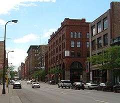
|
A look down First Avenue in the Warehouse District. | |
  | |
| Location | Minneapolis, Minnesota |
|---|---|
| Coordinates | 44°59′13″N 93°16′35″W / 44.98694°N 93.27639°WCoordinates: 44°59′13″N 93°16′35″W / 44.98694°N 93.27639°W |
| Architect | Multiple |
| Architectural style | Classical Revival, Other, Romanesque |
| NRHP Reference # | 89001937[4] |
| Added to NRHP | November 3, 1989 |
For most of its history, the North Loop was an industrial area. It was home to a large railroad yard and numerous warehouses and factories. Much of the warehouse district (very roughly bounded by Second Street North, First Avenue North, Sixth Street North, and the BNSF Railway tracks, except for the Interstate 394 and Interstate 94 ramps) is listed on the National Register of Historic Places.
The warehouses that characterize the district are mostly six to eight stories high, and about 62 structures on seven square blocks contribute to the district. The predominant form of design is the Chicago Commercial style, but many other styles were built, including Italianate, Queen Anne style, Richardsonian Romanesque, Classical Revival, and early 20th century commercial styles. The warehouse district was in turn associated with the railroad transportation network that was under development at the time, which connected Minneapolis with the rest of the Midwest and the rest of the country. These warehouses were used for wholesale and storage of goods related to milling and manufacturing. The nomination for the National Register of Historic Places states that the district, as a whole, comprises a cohesive district of buildings with a common physical appearance, as well as a common age and original use.[5]
In the 1980s, the Warehouse district was the epicenter of the Minneapolis art scene until the area's buildings became more commercially desirable in the 1990s. At its peak, the Wyman Building, 400 First Avenue North, was home to more than twenty contemporary art galleries. No Name Gallery was formerly located in the eastern part of the neighborhood, before it moved out of the district and became the Soap Factory .
Today
While some industrial tenants remain (particularly in the area southwest of 4th Street), many of the old factories and warehouses have been converted to commercial space or loft condominiums and apartments. The area still retains some feel of its industrial past, as many newer buildings have attempted to replicate the style of the old warehouses.
Since the mid-1990s, when the gentrification of the neighborhood accelerated, thousands of people have moved into the North Loop. The neighborhood is particularly popular with people who work in downtown Minneapolis, whose proximity allows residents to walk, bike, or take a short bus or METRO ride to work. Coffee shops, restaurants, bars, art galleries, and small retail stores have also moved into the neighborhood in recent years.
The Tony-award winning Theatre de la Jeune Lune (Closed and building sold) and the Traffic Zone Center for Visual Art, a prominent artist cooperative and gallery space, are located in the eastern part of the neighborhood. The largest employer is the Federal Reserve Bank of Minneapolis, which is located at the southwest end of the Hennepin Avenue Bridge.
In September 2006, the North Loop Neighborhood Association received funding to build a dog park for North Loop residents. A temporary dog park has been built on 3rd St and 7th Ave.
Target Field, home of the Minnesota Twins, opened in 2010, is on the southwest edge of the neighborhood. Plans call for the construction of condominiums and apartments for several thousand new residents near the stadium. The area is also served by Target Field (Metro Transit Station), the new terminus for the Northstar Commuter Rail, Metro Transit Blue, Green and future light rail lines.
See also
References
- ↑ "North Loop neighborhood in Minneapolis, Minnesota (MN), 55401, 55403, 55405, 55411 detailed profile". City-Data. 2011. Retrieved 2013-11-12.
- ↑ "Minneapolis Neighborhood Profile: North Loop" (PDF). Minnesota Compass. October 2011. Retrieved 2013-11-12.
- ↑ "MN Public Radio". Retrieved 2011-04-06.
- ↑ National Park Service (2006-03-15). "National Register Information System". National Register of Historic Places. National Park Service.
- ↑ "Certificate of Appropriateness for New Construction for the Parking Ramp Component of the Pacific Development Project" (PDF). Minneapolis Heritage Preservation Commission. November 28, 2006. Retrieved 2007-03-08.
"Veronique Wantz Gallery settles in North Loop" The Line
External links
| Wikimedia Commons has media related to North Loop, Minneapolis. |
- North Minneapolis Encyclopedia
- Stein LLC Neighborhood Retail Design Firm
- North Loop Neighborhood Association
- Warehouse District Business Association (WDBA)
- Theatre de la Jeune Lune
- Traffic Zone Center for Visual Art
- Minneapolis Heritage Preservation Commission map of the Warehouse District
- Veronique Wantz Gallery
| Topics | |
|---|---|
| Lists by states |
|
| Lists by insular areas | |
| Lists by associated states | |
| Other areas | |
| |
 |
Near North | St. Anthony West | | |
| Sumner-Glenwood Harrison |
|
Nicollet Island/East Bank | ||
| ||||
| | ||||
| Lowry Hill | Loring Park | Downtown West |