North Las Vegas Airport
| North Las Vegas Airport | |||||||||||||||||||
|---|---|---|---|---|---|---|---|---|---|---|---|---|---|---|---|---|---|---|---|
|
| |||||||||||||||||||
.jpg) View from an SR22 aircraft over North Las Vegas Airport, March 2013. | |||||||||||||||||||
| IATA: VGT – ICAO: KVGT – FAA LID: VGT | |||||||||||||||||||
| Summary | |||||||||||||||||||
| Airport type | Public | ||||||||||||||||||
| Operator | Clark County | ||||||||||||||||||
| Serves | Las Vegas, Nevada | ||||||||||||||||||
| Location | North Las Vegas, Nevada | ||||||||||||||||||
| Elevation AMSL | 2,205 ft / 672 m | ||||||||||||||||||
| Coordinates | 36°12′38″N 115°11′40″W / 36.21056°N 115.19444°WCoordinates: 36°12′38″N 115°11′40″W / 36.21056°N 115.19444°W | ||||||||||||||||||
| Website |
www | ||||||||||||||||||
| Maps | |||||||||||||||||||
 | |||||||||||||||||||
 VGT Location in Nevada | |||||||||||||||||||
| Runways | |||||||||||||||||||
| |||||||||||||||||||
| Statistics (2014) | |||||||||||||||||||
| |||||||||||||||||||
North Las Vegas Airport (IATA: VGT, ICAO: KVGT, FAA LID: VGT) is three miles northwest of downtown Las Vegas, in North Las Vegas, Nevada.[1] It is owned by Clark County and operated by the Clark County Department of Aviation.
Known locally as Northtown, it is the second busiest airport in the Las Vegas area and the third busiest in Nevada. It is the primary airport in the Las Vegas area for general aviation and scenic tours, allowing McCarran International Airport to focus on airline flights. North Las Vegas does offer limited regional airline service. Many helicopter operators including the Las Vegas Metropolitan Police Department use the airport.
The airport is certificated under 14 CFR Part 139.
History
The airport opened on December 7, 1941, as Sky Haven Airport. Given the significance of the date, only one of the three founders, Florence Murphy, remained to run the airport.[2]
Sky Rider Motel opened in the early 1960s during an expansion project at the airport, featuring a swimming pool shaped like an airplane.[2]
In 1968 Hughes Tool Company purchased the airport, then called North Las Vegas Air Terminal.[2]
Facilities
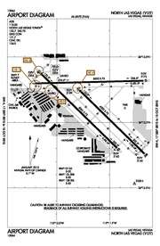
North Las Vegas Airport covers 920 acres (370 ha) at an elevation of 2,205 feet (672 m). It has three asphalt runways: 7/25 is 5,005 by 75 feet (1,525 x 23 m), 12R/30L is 5,001 by 75 feet (1,524 x 23 m), and 12L/30R is 4,203 by 75 feet (1,281 x 23 m).[1]
In the year of 2014 the airport had 126,942 aircraft operations, average 348 per day: 94% civil, 5% air taxi and <1% military.[3] As of August, 2015 there were 536 aircraft based at this airport: 76% single-engine, 14% multi-engine, 4% jet, 6% helicopter and <1% ultralight.[4]
Airlines and destinations
| Airlines | Destinations |
|---|---|
| Vision Airlines | Grand Canyon |
Runway incursions
The airport has worked on a program to reduce the number of runway incursions at the airport. For the year of 2007, North Las Vegas ranked #2 in airports with most runway incursions.
Incidents and accidents
On August 30, 1978, Las Vegas Airlines Flight 44, a Piper PA-31-350 Navajo Chieftain (N44LV), crashed in VFR conditions shortly after takeoff from runway 25. Flight 44 was a charter flight from Las Vegas, Nevada, to Santa Ana, California, with nine Australian tourists and a pilot on board. After liftoff following a longer-than-normal ground roll, the aircraft pitched nose up, climbed steeply to about 400 ft above the ground, stalled, reversed course, and crashed 1,150 ft beyond and 650 ft to the right of the runway. All persons on board the aircraft were killed. The National Transportation Safety Board determined that the probable cause of the accident was a backed out elevator down-stop bolt that limited down elevator travel and made it impossible for the pilot to prevent a pitchup and stall after takeoff. There was no fire.[5][6][7]
On January 2, 2013, a twin-engine Piper Aerostar crashed and burst into flames at North Las Vegas Airport after a hard landing. The two occupants escaped uninjured.[8]
References
- 1 2 3 FAA Airport Master Record for VGT (Form 5010 PDF). Federal Aviation Administration. Effective April 10, 2008.
- 1 2 3 "The History of North Las Vegas Airport". North Las Vegas Airport. Clark County Department of Aviation. 2014. Retrieved August 1, 2014.
- ↑ "ATADS : Airport Operations : Standard Report". Airport Operations. FAA. 2015. Retrieved September 17, 2015.
- ↑ "AIRCRAFT ACCIDENT REPORT - LAS VEGAS AIRLINES, PIPER PA-31-350, N44LV, LAS VEGAS, NEVADA, AUGUST 30, 1978 - Transport Research International Documentation - TRID". Retrieved 3 June 2015.
- ↑ http://www.airdisaster.com/reports/ntsb/AAR79-08.pdf
- ↑ "Las Vegas, NV Plane Crashes After Take-Off, Aug 1978". Retrieved 3 June 2015.
- ↑ Craig Huber (2 January 2013). "Plane bursts into flames at North Las Vegas Airport". Retrieved 3 June 2015.
External links
- North Las Vegas Airport - Official website
- "Diagram of North Las Vegas Airport (VGT)" (PDF). from Nevada DOT
- FAA Airport Diagram (PDF), effective December 8, 2016
- FAA Terminal Procedures for VGT, effective December 8, 2016
- Resources for this airport:
- FAA airport information for VGT
- AirNav airport information for KVGT
- ASN accident history for VGT
- FlightAware airport information and live flight tracker
- NOAA/NWS latest weather observations
- SkyVector aeronautical chart, Terminal Procedures