North Carolina Highway 241
| ||||
|---|---|---|---|---|
 | ||||
| Route information | ||||
| Maintained by NCDOT | ||||
| Length: | 9.4 mi[1] (15.1 km) | |||
| Existed: | 1971 – present | |||
| Major junctions | ||||
| South end: |
| |||
| North end: |
| |||
| Location | ||||
| Counties: | Duplin, Lenoir | |||
| Highway system | ||||
| ||||

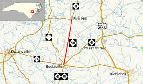
North Carolina Highway 241 (NC 241) is a primary state highway in the U.S. state of North Carolina. It connects Beulaville in Duplin County with Pink Hill in Lenoir County.
Route description
NC 241 is a rather straight, predominantly two-lane, rural highway between Beulaville and Pink Hill. Traversing mainly through farmland, it connects the two major state highways of NC 24 and NC 11. For the first 3⁄10 mile (0.48 km) of the highway in Beulaville, NC 241 is also concurrent with NC 41 and NC 111.[1]
History
NC 241 has existed twice before. The first existed for one year, from 1923 to 1924; it traveled from NC 60 in Jonesboro, to NC 24 in Fayetteville. It was replaced by an extension of NC 53.
The second NC 241 was established in 1930 as a new primary routing, from NC 70 in Aberdeen, south through Laurinburg, to the community of Johns.[2] In 1931, it was extended south to NC 130 in Seven Bridges. In 1932, NC 241 was straightened out between Laurinburg and Aberdeen; the same year, U.S. Route 311 (US 311) was assigned to the entire routing of NC 241. In 1934, U.S 501 replaced US 311 along the route and also decommissioned all of NC 241.
The third and current NC 241 was established in 1971 as an upgrading of secondary roads SR 1005 in Duplin County and SR 1106 in Lenoir County.
Junction list
| County | Location | mi[1] | km | Destinations | Notes |
|---|---|---|---|---|---|
| Duplin | Beulaville | 0.0 | 0.0 | Southern end of NC 41 and NC 111 overlaps | |
| 0.3 | 0.48 | Northern end of NC 41 and NC 111 overlaps | |||
| Lenoir | Pink Hill | 9.4 | 15.1 | ||
1.000 mi = 1.609 km; 1.000 km = 0.621 mi
| |||||
References
- 1 2 3 Google (May 12, 2014). "North Carolina Highway 241" (Map). Google Maps. Google. Retrieved May 12, 2014.
- ↑ State Highway System of North Carolina (PDF) (Map). Cartography by NCDOT. North Carolina Department of Transportation. 1930. Retrieved May 12, 2014.
External links
-
 Media related to North Carolina Highway 241 at Wikimedia Commons
 - NCRoads.com: N.C. 241