North Carolina Highway 106
North Carolina Highway 106 | |||||||
|---|---|---|---|---|---|---|---|
 | |||||||
| Route information | |||||||
| Maintained by GDOT and NCDOT | |||||||
| Length: |
14.31 mi[1][2] (23.03 km) GA 246: 3.12 miles (5.02 km) NC 106: 11.19 miles (18.01 km) | ||||||
| Existed: | 1940 – present | ||||||
| Major junctions | |||||||
| West end: |
| ||||||
| North end: |
| ||||||
| Location | |||||||
| States: | Georgia, North Carolina | ||||||
| Counties: | GA: Rabun NC: Macon | ||||||
| Highway system | |||||||
| |||||||


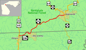
Georgia State Route 246 (SR 246) and North Carolina Highway 106 (NC 106) are actually a pair of highway designations that run concurrently on a single road that runs from Dillard, Georgia to Highlands, North Carolina. The route is unique for its five state crossings between Georgia and North Carolina along the southern slopes of Kinley Mountain.
Route description
SR 246 begins at the intersection of US 23/US 441/SR 15, in Dillard, Georgia. As it enters North Carolina for the first time, the road widens to improve staying in the curves, with the north-east side becoming two lanes. During the third incursion in Georgia, there is an overlook with a clear view toward the west of the town of Dillard. The overlook is above Estatoah Falls but can not be seen. The falls are on private property and cannot be accessed. They can be seen only at a distance from Hwy 246 heading from Dillard to Sky Valley. By the final border crossing the highway will merge back into two-lanes. Continuing north in North Carolina, several roads near the border connect back into Georgia to the mountain resort area of Sky Valley. Passing through the community of Scaly Mountain, the highway ends at US 64/NC 28, in Highlands.[3]
In Georgia, the route is designated east-west, while in North Carolina it is north-south. While the highway is maintained by Georgia Department of Transportation (GDOT) until the final border crossing, The highway is still recognized as NC 106 (Dillard Road) within North Carolina and same for SR 246 (Highlands Road/Larry McClure Highway) in Georgia.
History
NC 106 was established in 1940 as new primary routing from the Georgia state line to Highlands. It has changed little since inception.
Originally, from 1921-1940, NC 106 traversed from NC 28, in Cashiers, to NC 10, in Sylva. In 1931, it was extended south to the South Carolina state line. In 1940, it was renumbered to NC 107 to sync with South Carolina.
Previously there were five sets of welcome signs announcing the crossings of the state line. There is now only a single pair of signs (either at the middle or easternmost crossing), but with very small signs like mileposts marking each intermediate crossing, with GA or NC written from top to bottom instead of numbers.
Junction list

| County | Location | mi [1][2] | km | Destinations | Notes |
|---|---|---|---|---|---|
| Rabun | Dillard | 0.00 | 0.00 | Western terminus of SR 246 | |
| 1.99 | 3.20 | Georgia–North Carolina state line Western terminus of NC 106 | |||
| 2.22 | 3.57 | North Carolina–Georgia state line | |||
| 2.32 | 3.73 | Georgia–North Carolina state line | |||
| 2.69 | 4.33 | North Carolina–Georgia state line | |||
| 3.82 | 6.15 | Georgia–North Carolina state line Eastern terminus of SR 246 | |||
| Macon | Highlands | 14.31 | 23.03 | Eastern terminus of NC 106 | |
| 1.000 mi = 1.609 km; 1.000 km = 0.621 mi | |||||
See also
-
.svg.png) Georgia (U.S. state) portal
Georgia (U.S. state) portal -
 North Carolina portal
 -
 U.S. Roads portal
References
- 1 2 Geographic Transportation Reporting Analysis and Query System (GeoTRAQS) (Map). Georgia Department of Transportation. Retrieved 2012-07-05.
- 1 2 Statewide Primary & Secondary Road Arcs (ESRI shapefile) (Map). North Carolina Department of Transportation. 2012. Retrieved 2012-07-05.
- ↑ Google (June 4, 2013). "Route of Georgia State Route 246 and North Carolina Highway 106" (Map). Google Maps. Google. Retrieved June 4, 2013.
External links
 Media related to Georgia State Route 246 at Wikimedia Commons
- Media related to North Carolina Highway 106 at Wikimedia Commons
- NCRoads.com: N.C. 106
- Profile on MotorcycleRoads.US
- State road names in Rabun County
- Peach State Roads
- 1999 resolution naming highway