North Acton tube station
| North Acton | |
|---|---|
 | |
 North Acton Location of North Acton in Greater London | |
| Location | North Acton |
| Local authority | London Borough of Ealing |
| Managed by | London Underground |
| Number of platforms | 3 |
| Fare zone | 2 and 3 |
| London Underground annual entry and exit | |
| 2012 |
|
| 2013 |
|
| 2014 |
|
| 2015 |
|
| Key dates | |
| 1923 | Opened |
| Other information | |
| Lists of stations | |
| WGS84 | 51°31′25″N 0°15′35″W / 51.5236°N 0.2597°WCoordinates: 51°31′25″N 0°15′35″W / 51.5236°N 0.2597°W |
|
| |
North Acton is a London Underground station in North Acton, west London in the London Borough of Ealing. The station is on the Central line between East Acton and Hanger Lane on the West Ruislip Branch and West Acton on the Ealing Broadway Branch. It is on the boundary of Travelcard Zone 2 and Zone 3.
History

The joint New North Main Line (NNML) of the Great Central and Great Western opened in 1903 and its North Acton railway station followed in 1904. The Great Western Railway (GWR) built the Ealing & Shepherd's Bush Railway, which connected the Central London Railway (CLR) with the GWR's Ealing Broadway station. CLR trains began using the route on 3 August 1920.[2] The stations at North Acton and West Acton were built and owned by the GWR, and both opened on 5 November 1923.[3] As Transport for London explains:[4]
| “ | On 18 August 1911, the Central London Railway abandoned its policy of no through running with any other railway, and secured powers to build a short extension from Wood Lane to connect with the intended Ealing & Shepherds Bush line of the Great Western Railway, over which it proposed to exercise running powers. | ” |
North of the Central line tracks were two freight lines, removed in the 1960s, running alongside the Central line as far as White City; to the north of those at a slightly higher level were the two tracks of the NNML.[5][6][7] The footbridge to the NNML platforms is on the extreme left of this 1933 photograph.[8] Today, only the outer-most NNML platform remains partially intact.[9][10]
The NNML platforms closed when the Central line was extended on new track from North Acton to Greenford station in 1947. Between South Ruislip station and Old Oak Junction, the GWR line was progressively run down, and in many places it is now single-track, including the stretch running past North Acton. By May 2008, only freight trains and a once-daily passenger service provided by Chiltern Railways used this stretch of line.
The Underground station had only two platforms until 1992,[11] whereby for operational flexibility an island platform was created by building a third platform north of the other two, where the old freight line track bed had been. The third platform became the eastbound road and the erstwhile eastbound platform (now the middle platform) was resignalled to allow it to be used also for terminating and starting services. This change allows shuttle services to be run to White City from Ealing Broadway and from West Ruislip in the event of problems elsewhere on the Central line, and at certain times of the day some trains coming from central London are scheduled to terminate at North Acton .
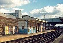
Today
Passenger access is down from the booking hall, which is part-way down the southern side of the cutting with two exits up to Victoria Road. This is the last station before the Central line splits into the West Ruislip and Ealing Broadway branches. Approximately half the trains stopping at the station head to each destination. The support centre for Carphone Warehouse and numerous other companies have offices in the vicinity. There are approximately 600 new flats directly opposite the station, and there is a Holiday Inn Express hotel next door to the station with the Ramada Encore hotel another five minutes' walk away. A new Tesco 'Express' store is now open along with a Lebanese restaurant in the opposite block.
Development
There have been vague and uncosted suggestions over the years to move the station to the east to provide an interchange with the North London Line. This would, however, be in an area with no extra passenger generation, and merely to move the station for interchange purposes has never been sufficient reason. The idea was revived in February 2008, when the Greater London Authority stated in a 'Park Royal draft Opportunity Area Planning Framework'[12] that
| “ | There may be potential for an interchange between the Central line and North London Line at North Acton. This is purely aspirational at this stage, and would require investigation to determine cost, finance and feasibility. | ” |
In 2004, the multinational Diageo company agreed to build Central line platforms at Park Royal station to the west of North Acton,[13][14] as part of its First Central business park,[15] built on the site of the now demolished Guinness brewery. By 2013 this had not yet happened. Such a new station might influence whether adjacent stations were ever moved (particularly Hanger Lane station not far to the west). The entrance to a 'North London Line' North Acton station could be just a few metres on the other side of Victoria Road from the current North Acton station eastern entrance. There is a footpath to the west immediately next to the railway, from nearby Chase Road to Park Royal Road.
Connections
London Buses route 95, 260, 266, 440 and 487 serve the station.
Gallery
| Wikimedia Commons has media related to North Acton tube station. |
 looking west, with westbound (left) and eastbound trains
 Looking east, with the island platform on the left
 Looking west, with the island platform on the right
 Looking west, with the disused GWR station on the extreme right
 Roundel on westbound platform
References
- 1 2 3 4 "Multi-year station entry-and-exit figures" (XLS). London Underground station passenger usage data. Transport for London. April 2016. Retrieved 3 May 2016.
- ↑ Day, John R.; Reed, John (2008) [1963]. The Story of London's Underground (10th ed.). Harrow: Capital Transport. p. 90. ISBN 978-1-85414-316-7.
- ↑ Day & Reed 2008, p. 91
- ↑ Transport for London : Central line facts
- ↑ "The Crookes Laboratories Ltd off Gorst Road and the surrounding industrial area, North Acton, 1947. This image was marked by Aerofilms Ltd for photo editing.". Britain from Above. Retrieved 2014-08-29.
- ↑ "Industrial properties between Victoria Road and Wales Farm Road, North Acton, 1948. This image was marked by Aerofilms Ltd for photo editing.". Britain from Above. Retrieved 2014-08-29.
- ↑ "The Ducon Condenser Works and the surrounding residential and industrial area, North Acton, 1938. This image has been produced from a damaged negative.". Britain from Above. Retrieved 2014-08-29.
- ↑ London Transport Museum Historical photograph of North Acton station in 1933
- ↑ Jones, Richard (2006-04-17). "37425 North Acton, 17/04/06". Flickr. Retrieved 2014-09-03.
- ↑ Lang, Duncan (2013-03-18). "Untitled". Flickr. Retrieved 2014-09-03.
- ↑ Heywood, Paul (2014-08-18). "London". Flickr. Retrieved 2014-08-29.
- ↑ Greater London Authority Park Royal draft Opportunity Area Planning Framework
- ↑ alwaystouchout Park Royal Central line platforms
- ↑ London Borough of Brent: Central line agreement Audit trail for planning agreement not all on-line, but starts here
- ↑ First Central business park Map of Park Royal Central line platforms
| Preceding station | Following station | |||
|---|---|---|---|---|
towards West Ruislip | Central line | |||
towards Ealing Broadway |
||||
| Service arrangement if Old Oak Common opens | ||||
| Preceding station | Following station | |||
towards West Ruislip | Central line | |||
towards Ealing Broadway |
||||
| Stations |
| ||||||||||||||||||||||||
|---|---|---|---|---|---|---|---|---|---|---|---|---|---|---|---|---|---|---|---|---|---|---|---|---|---|
| Rolling stock | |||||||||||||||||||||||||
| History |
| ||||||||||||||||||||||||
| Proposed stations | |||||||||||||||||||||||||
| Depots | |||||||||||||||||||||||||
| |||||||||||||||||||||||||