Nordhausen (district)
Nordhausen is a Kreis (district) in the north of Thuringia, Germany. Neighboring districts are (from the north clockwise) Harz and Mansfeld-Südharz in Saxony-Anhalt, the district Kyffhäuserkreis, Eichsfeld in Thuringia and the districts Göttingen and Goslar in Lower Saxony.
History
The district was created in 1815, when the Prussian province Saxony was created. The area Lohra-Clettenberg (the former dukedom County Hohnstein) and the previously free imperial city Nordhausen were thereafter administrated together. 1882/83 the city Nordhausen left the district, which led to the renaming of the district to Kreis Grafschaft Hohenstein (district county Hohenstein) in 1888. After World War II the district was named back to Landkreis Nordhausen, and in 1950 the city Nordhausen had to join the district again. In the administrative reform of 1952 several municipalities changed the district - several changed from the district Sangerhausen into the district Nordhausen, while others from Nordhausen changed into the districts Worbis, Wernigerode, Sondershausen and Sangerhausen.
Geography
The district is located in the southern foothills of the Harz mountains.
Highest elevation is the Große Ehrenberg, with a height of 635.3 m above sea level.
The main river in the district is the Zorge.
To the south are the hill chains of the Dün, Hainleite and Windleite.
Coat of arms
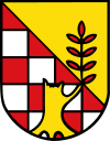 |
The checkered red-silver part of the coat of arms is derived from the coat of arms of the County Hohenstein, the historical territory the district belonged to. The tree trunk symbolizes the destruction of the city Nordhausen during World War II, with the new branch growing into the golden area symbolizing the reconstruction of the city and the bright future. |
Towns and municipalities
References
External links
|
|---|
|
| Urban districts | |
|---|
|
| Rural districts | |
|---|
Coordinates: 51°30′N 10°45′E / 51.5°N 10.75°E / 51.5; 10.75
